New Haven Topo Map Connecticut
To zoom in, hover over the map of New Haven
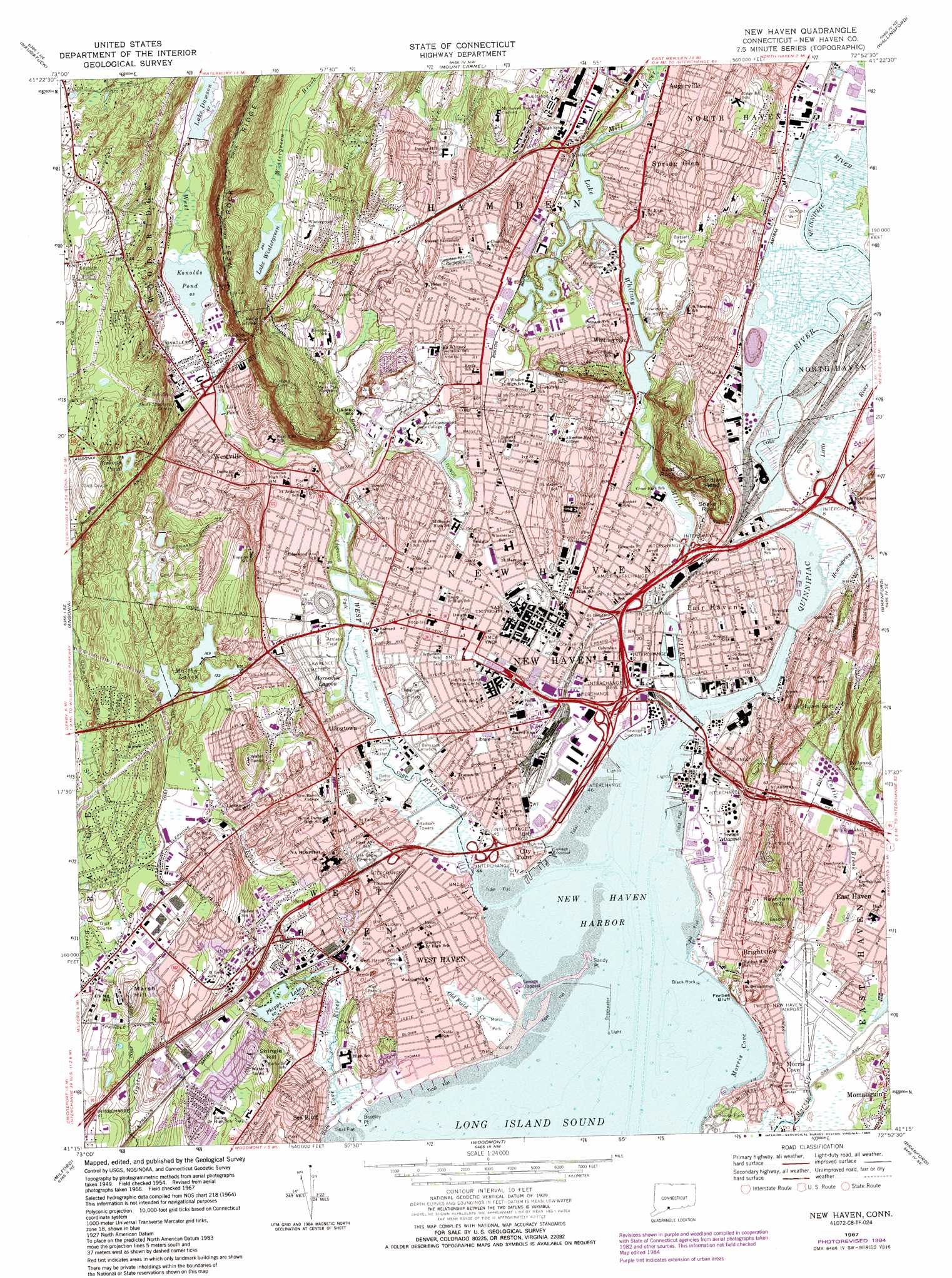
USGS Topo Quad 41072c8 - 1:24,000 scale
| Topo Map Name: | New Haven |
| USGS Topo Quad ID: | 41072c8 |
| Print Size: | ca. 21 1/4" wide x 27" high |
| Southeast Coordinates: | 41.25° N latitude / 72.875° W longitude |
| Map Center Coordinates: | 41.3125° N latitude / 72.9375° W longitude |
| U.S. State: | CT |
| Filename: | o41072c8.jpg |
| Download Map JPG Image: | New Haven topo map 1:24,000 scale |
| Map Type: | Topographic |
| Topo Series: | 7.5´ |
| Map Scale: | 1:24,000 |
| Source of Map Images: | United States Geological Survey (USGS) |
| Alternate Map Versions: |
New Haven CT 1954, updated 1959 Download PDF Buy paper map New Haven CT 1954, updated 1960 Download PDF Buy paper map New Haven CT 1954, updated 1960 Download PDF Buy paper map New Haven CT 1954, updated 1964 Download PDF Buy paper map New Haven CT 1967, updated 1970 Download PDF Buy paper map New Haven CT 1967, updated 1974 Download PDF Buy paper map New Haven CT 1967, updated 1979 Download PDF Buy paper map New Haven CT 1967, updated 1985 Download PDF Buy paper map New Haven CT 1967, updated 1985 Download PDF Buy paper map New Haven CT 2012 Download PDF Buy paper map New Haven CT 2015 Download PDF Buy paper map |
1:24,000 Topo Quads surrounding New Haven
Woodbury |
Waterbury |
Southington |
Meriden |
Middletown |
Southbury |
Naugatuck |
Mount Carmel |
Wallingford |
Durham |
Long Hill |
Ansonia |
New Haven |
Branford |
Guilford |
Bridgeport |
Milford |
Woodmont |
||
> Back to 41072a1 at 1:100,000 scale
> Back to 41072a1 at 1:250,000 scale
> Back to U.S. Topo Maps home
New Haven topo map: Gazetteer
New Haven: Airports
Bob Thomas Ford Heliport elevation 25m 82′HSI Heliport elevation 24m 78′
North Haven Heliport elevation 2m 6′
Partyka Chevrolet Heliport elevation 20m 65′
Tweed-New Haven Airport elevation 6m 19′
Yale New Haven Hospital Heliport elevation 19m 62′
New Haven: Bars
Bradley Rocks elevation 0m 0′Pardee Bar elevation 0m 0′
Savin Rock elevation 0m 0′
Shag Bank elevation 0m 0′
Shag Bar elevation 0m 0′
New Haven: Bays
Morris Cove elevation 0m 0′New Haven Harbor elevation 0m 0′
Winter Harbor elevation 0m 0′
New Haven: Beaches
Sea Bluff Beach elevation 0m 0′New Haven: Bridges
Chapel Street Bridge elevation 0m 0′Ferry Bridge elevation 0m 0′
Grand Avenue Bridge elevation 1m 3′
Lewis Bridge elevation 0m 0′
State Street Bridge elevation 11m 36′
Thomson Bridge elevation 7m 22′
Tomlinson Bridge elevation 0m 0′
Towns Bridge elevation 12m 39′
Water Street Bridge elevation 0m 0′
West River Bridge elevation 3m 9′
New Haven: Capes
Bradley Point elevation 0m 0′City Point elevation 0m 0′
Dragon Point elevation 0m 0′
Fort Hale Point elevation 0m 0′
Grape Vine Point elevation 1m 3′
Great Neck elevation 11m 36′
Morris Neck elevation 9m 29′
Stable Point elevation 0m 0′
Wigwam Neck elevation 14m 45′
New Haven: Cliffs
Forbes Bluff elevation 5m 16′Sandy Point elevation 0m 0′
New Haven: Crossings
Interchange 1 elevation 9m 29′Interchange 2 elevation 9m 29′
Interchange 3 elevation 10m 32′
Interchange 41 elevation 28m 91′
Interchange 42 elevation 35m 114′
Interchange 43 elevation 6m 19′
Interchange 44 elevation 7m 22′
Interchange 46 elevation 3m 9′
Interchange 47 elevation 11m 36′
Interchange 48 elevation 9m 29′
Interchange 50 elevation 9m 29′
Interchange 51 elevation 7m 22′
Interchange 6 elevation 8m 26′
Interchange 60 elevation 27m 88′
Interchange 7 elevation 15m 49′
Interchange 8 elevation 9m 29′
New Haven: Dams
Farm Brook Site 2A Dam elevation 33m 108′Farm Brook Site 2B Dam elevation 33m 108′
Lake Whitney Dam elevation 11m 36′
Lake Wintergreen Dam elevation 73m 239′
Maltby Lake Dam Number 1 elevation 41m 134′
Maltby Lakes North Dam elevation 52m 170′
Maltby Lakes West Dam elevation 49m 160′
Sandy Point Dike elevation 0m 0′
Upper Lake Phipps Dam Number 1 elevation 22m 72′
Upper Lake Phipps Dam Number 2 elevation 18m 59′
Whitney Dam elevation 12m 39′
New Haven: Flats
West Haven Flats elevation 0m 0′New Haven: Islands
Ball Island elevation 1m 3′Black Rock elevation 0m 0′
New Haven: Lakes
Bishops Pond elevation 110m 360′Center Pond elevation 5m 16′
Horseshoe Lagoon elevation 5m 16′
Konolds Pond elevation 25m 82′
Lake Wintergreen elevation 73m 239′
Maltby Lake elevation 50m 164′
Pollywog Pond elevation 4m 13′
New Haven: Mines
Blakeslee Quarry (historical) elevation 27m 88′Pine Rock Quarry elevation 27m 88′
New Haven: Parks
Allington Park elevation 14m 45′Amistad Memorial elevation 17m 55′
Anthony Thompson Field elevation 12m 39′
Art Park elevation 10m 32′
Bassett Park elevation 43m 141′
Bayview Park elevation 2m 6′
Bayview Park elevation 8m 26′
Beaver Hills Historic District elevation 30m 98′
Beaver Ponds Park elevation 14m 45′
Beecher Park elevation 18m 59′
Bowen Field elevation 11m 36′
Bowling Green elevation 14m 45′
Broadway Squares elevation 21m 68′
Chapel Street Historic District elevation 13m 42′
Clinton Park elevation 14m 45′
Columbus Park elevation 19m 62′
Constitution Square elevation 7m 22′
Daniel Stewart Plaza elevation 15m 49′
De Gale Field elevation 16m 52′
Decosta Playground elevation 17m 55′
Dewitt Cuyler Field elevation 13m 42′
East Rock Park elevation 53m 173′
East Shore Park elevation 4m 13′
Eaton Park elevation 20m 65′
Edgerton Park elevation 19m 62′
Edgewood Mall elevation 17m 55′
Edgewood Park elevation 7m 22′
Edgewood Park Historic District elevation 5m 16′
Elm Haven elevation 17m 55′
Fairmont Park elevation 24m 78′
Farnam Memorial Gardens elevation 41m 134′
Foote School Field elevation 42m 137′
Fort Wooster Park elevation 56m 183′
Franam Courts Playground elevation 7m 22′
Frank Field elevation 14m 45′
Franklin Square elevation 5m 16′
Garden Street Playground elevation 22m 72′
Hillhouse Avenue Historic District elevation 14m 45′
Howard Avenue Historic District elevation 16m 52′
Jess Dow Field elevation 22m 72′
Jocelyn Square elevation 5m 16′
Ken Strong Stadium elevation 3m 9′
Kensington Playground elevation 18m 59′
Kimberly Playgrounds elevation 7m 22′
Lenzi Playground elevation 9m 29′
Lighthouse Point Park elevation 12m 39′
Marsh Botanical Gardens elevation 11m 36′
Monitor Square elevation 22m 72′
Moore Field elevation 17m 55′
Morris Triangle elevation 10m 32′
Morse Park elevation 7m 22′
Munson Street Triangle elevation 16m 52′
Nathan Hale Park elevation 15m 49′
New Haven Green elevation 16m 52′
New Haven Green Historic District elevation 15m 49′
Nike Site Park elevation 45m 147′
Ninth Square Historic District elevation 15m 49′
Orange Street Historic District elevation 14m 45′
Oyster Point Historic District elevation 13m 42′
Painter Park elevation 23m 75′
Pardee Rose Garden elevation 29m 95′
Phelphs Triangle elevation 11m 36′
Prospect Gardens elevation 40m 131′
Quigley Stadium elevation 19m 62′
Quinnipiac Park elevation 2m 6′
Quinnipiac River Historic District elevation 13m 42′
Quinnipiac River Marsh Wildlife Area elevation 2m 6′
Ray Park elevation 14m 45′
River Street Historic District elevation 6m 19′
Sherman Triangle elevation 14m 45′
Shingle Hill Park elevation 16m 52′
Spireworth Park elevation 16m 52′
State Street Triangle elevation 9m 29′
The Esplanade elevation 14m 45′
Trowbridge Square Historic District elevation 15m 49′
Upper State Street Historic District elevation 10m 32′
Walter Camp Field elevation 22m 72′
Washington Playgrounds elevation 12m 39′
West Haven Green elevation 11m 36′
West River Wildlife Sanctuary elevation 3m 9′
West Rock Park elevation 102m 334′
West Rock Playground elevation 8m 26′
West Rock Ridge State Park elevation 112m 367′
Wexler Triangle elevation 17m 55′
Whitney Avenue Historic District elevation 17m 55′
Whitney Grove Square elevation 12m 39′
Wooster Playground elevation 9m 29′
Wooster Square elevation 9m 29′
Wooster Square Historic District elevation 9m 29′
New Haven: Pillars
Bradley Rocks elevation 0m 0′Pine Rock elevation 27m 88′
New Haven: Populated Places
Allingtown elevation 18m 59′Armoryville (historical) elevation 14m 45′
Augerville elevation 16m 52′
Barnesville elevation 6m 19′
Brewsterville (historical) elevation 9m 29′
Brightview elevation 23m 75′
City Point elevation 12m 39′
Fair Haven elevation 13m 42′
Fair Haven East elevation 23m 75′
Hemingway Town (historical) elevation 10m 32′
Highwood (historical) elevation 24m 78′
Liberia (historical) elevation 8m 26′
Momauguin elevation 11m 36′
Morris Cove elevation 6m 19′
New Guinea (historical) elevation 14m 45′
New Halville elevation 10m 32′
New Haven elevation 18m 59′
Raynham elevation 28m 91′
Savin Rock elevation 7m 22′
Sea Bluff elevation 33m 108′
Slineyville (historical) elevation 10m 32′
Spring Glen elevation 23m 75′
West Haven elevation 10m 32′
West Hills elevation 33m 108′
Westville elevation 30m 98′
Whitneyville elevation 25m 82′
New Haven: Post Offices
New Haven Main Branch Post Office elevation 8m 26′Yale Post Office elevation 23m 75′
New Haven: Reservoirs
Edgewood Park Pond elevation 9m 29′Farm Brook Site 2A Reservoir elevation 33m 108′
Farm Brook Site 2B Reservoir elevation 33m 108′
Iris Pond elevation 9m 29′
Lake Dawson elevation 49m 160′
Lake Whitney elevation 11m 36′
Lake Wintergreen elevation 73m 239′
Lily Pond elevation 26m 85′
Lily Pond elevation 6m 19′
Long Pond elevation 8m 26′
Maltby Lakes North elevation 52m 170′
Maltby Lakes West elevation 49m 160′
Maltby Lower Lake elevation 41m 134′
Phipps Lake elevation 18m 59′
Upper Lake Phipps elevation 22m 72′
Upper Lake Phipps elevation 18m 59′
New Haven: Springs
Ball Spring (historical) elevation 38m 124′Cold Spring elevation 14m 45′
New Haven: Streams
Belden Brook elevation 9m 29′Cove River elevation 0m 0′
Farm Brook elevation 27m 88′
Hemingway Creek elevation 0m 0′
Little River elevation 2m 6′
Mill River elevation 0m 0′
Old Field Creek elevation 1m 3′
Quinnipiac River elevation 0m 0′
Shepard Brook elevation 14m 45′
Silver Brook elevation 40m 131′
Trout Brook elevation 40m 131′
Tuttle Brook elevation 9m 29′
West River elevation 0m 0′
Wilmot Brook elevation 8m 26′
Wintergreen Brook elevation 5m 16′
New Haven: Summits
Allington Hill elevation 92m 301′Beacon Hill elevation 58m 190′
Chidsey Hill elevation 32m 104′
East Rock elevation 100m 328′
Indian Head elevation 77m 252′
Marsh Hill elevation 72m 236′
Mill Rock elevation 38m 124′
Raynham Hill elevation 47m 154′
Reservoir Hill elevation 36m 118′
Shingle Hill elevation 52m 170′
Snake Rock elevation 46m 150′
New Haven: Swamps
Beaver Pond Meadows elevation 14m 45′New Haven: Trails
Regicides Trail elevation 163m 534′New Haven: Tunnels
West Rock Tunnel elevation 107m 351′New Haven: Woods
College Woods elevation 14m 45′New Haven digital topo map on disk
Buy this New Haven topo map showing relief, roads, GPS coordinates and other geographical features, as a high-resolution digital map file on DVD:
New York, Vermont, Connecticut & Western Massachusetts
Buy digital topo maps: New York, Vermont, Connecticut & Western Massachusetts