Wallingford Topo Map Connecticut
To zoom in, hover over the map of Wallingford
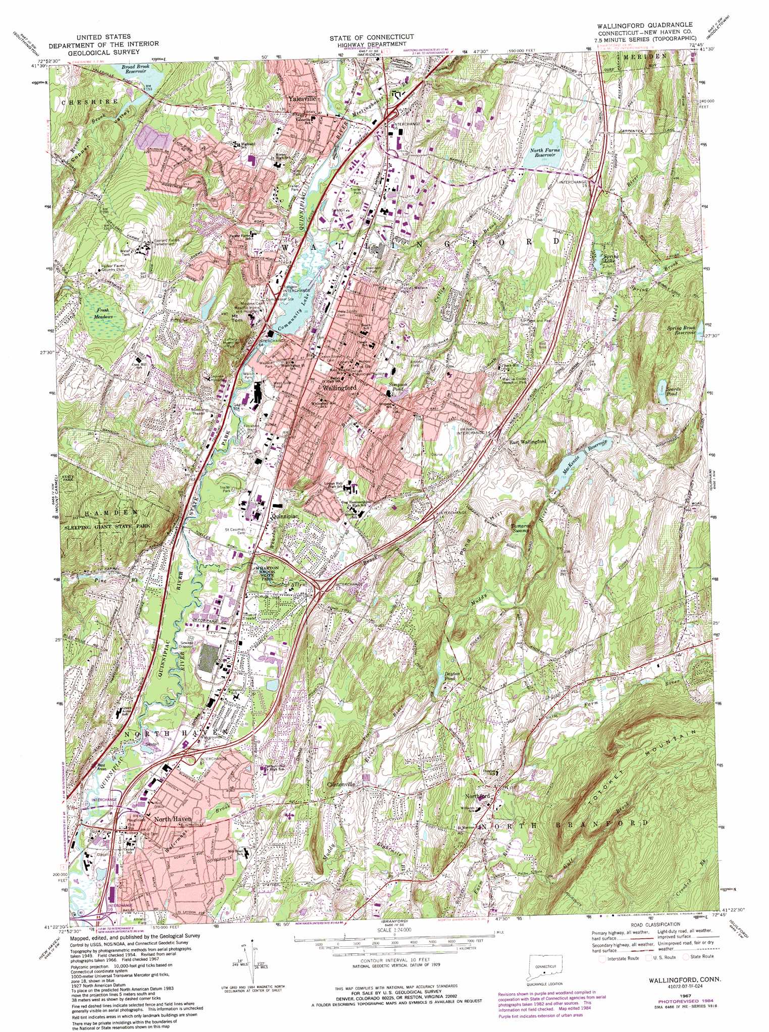
USGS Topo Quad 41072d7 - 1:24,000 scale
| Topo Map Name: | Wallingford |
| USGS Topo Quad ID: | 41072d7 |
| Print Size: | ca. 21 1/4" wide x 27" high |
| Southeast Coordinates: | 41.375° N latitude / 72.75° W longitude |
| Map Center Coordinates: | 41.4375° N latitude / 72.8125° W longitude |
| U.S. State: | CT |
| Filename: | o41072d7.jpg |
| Download Map JPG Image: | Wallingford topo map 1:24,000 scale |
| Map Type: | Topographic |
| Topo Series: | 7.5´ |
| Map Scale: | 1:24,000 |
| Source of Map Images: | United States Geological Survey (USGS) |
| Alternate Map Versions: |
Wallingford CT 1954, updated 1958 Download PDF Buy paper map Wallingford CT 1954, updated 1965 Download PDF Buy paper map Wallingford CT 1967, updated 1971 Download PDF Buy paper map Wallingford CT 1967, updated 1974 Download PDF Buy paper map Wallingford CT 1967, updated 1985 Download PDF Buy paper map Wallingford CT 2012 Download PDF Buy paper map Wallingford CT 2015 Download PDF Buy paper map |
1:24,000 Topo Quads surrounding Wallingford
Thomaston |
Bristol |
New Britain |
Hartford South |
Glastonbury |
Waterbury |
Southington |
Meriden |
Middletown |
Middle Haddam |
Naugatuck |
Mount Carmel |
Wallingford |
Durham |
Haddam |
Ansonia |
New Haven |
Branford |
Guilford |
Clinton |
Milford |
Woodmont |
> Back to 41072a1 at 1:100,000 scale
> Back to 41072a1 at 1:250,000 scale
> Back to U.S. Topo Maps home
Wallingford topo map: Gazetteer
Wallingford: Airports
American Cyanamid Company Heliport elevation 19m 62′Bristol-Myers/Squibb Company Heliport elevation 134m 439′
Clark Heliport elevation 45m 147′
Wallingford Airport (historical) elevation 10m 32′
Wallingford: Bridges
Mansfield Bridge elevation 11m 36′Wallingford: Capes
Goat Point elevation 21m 68′Wallingford: Crossings
Interchange 10 elevation 12m 39′Interchange 11 elevation 13m 42′
Interchange 12 elevation 16m 52′
Interchange 13 elevation 27m 88′
Interchange 14 elevation 71m 232′
Interchange 14 elevation 75m 246′
Interchange 15 elevation 107m 351′
Interchange 66 elevation 31m 101′
Wallingford: Dams
MacKenzie Reservoir Dam elevation 62m 203′North Farms Reservoir Dam elevation 101m 331′
Simpson Pond Dam elevation 42m 137′
Upper River Pond Dam elevation 18m 59′
Wallingford: Lakes
Community Lake elevation 12m 39′Dayton Pond elevation 33m 108′
Simpson Pond elevation 42m 137′
Spring Lake elevation 81m 265′
Wooding Ice Pond (historical) elevation 16m 52′
Woodings Pond elevation 20m 65′
Wallingford: Parks
Carini Field elevation 46m 150′Coyle Field elevation 40m 131′
Doolittle Park elevation 28m 91′
Emerson Leonard Wildlife Area elevation 12m 39′
Harriet Wallace Park elevation 66m 216′
Harrison Park elevation 51m 167′
Lakeside Park elevation 16m 52′
Lyman Hall Monument elevation 34m 111′
Pines Bridge Historic District elevation 11m 36′
Pitch Pines Park elevation 20m 65′
Quinnipiac River State Park elevation 14m 45′
Triangular Park elevation 65m 213′
Vietnam Veterans Memorial Park elevation 62m 203′
Walco Park elevation 11m 36′
Wallace Park elevation 16m 52′
West Side Field Park elevation 16m 52′
Wharton Brook State Park elevation 17m 55′
William D Bertini Park elevation 62m 203′
Wallingford: Pillars
Smith Rock elevation 27m 88′Wallingford: Populated Places
Clintonville elevation 31m 101′East Wallingford elevation 82m 269′
North Haven elevation 21m 68′
North Haven Bridge elevation 12m 39′
Northford elevation 55m 180′
Quinnipiac elevation 22m 72′
Wallingford elevation 27m 88′
Yalesville elevation 28m 91′
Wallingford: Post Offices
Wallingford Post Office elevation 47m 154′Wallingford: Reservoirs
Brush Shop Pond elevation 55m 180′MacKenzie Reservoir elevation 59m 193′
North Farms Reservoir elevation 101m 331′
Scards Pond elevation 137m 449′
Spring Brook Reservoir elevation 116m 380′
Tylers Mill Pond (historical) elevation 54m 177′
Upper River Pond elevation 18m 59′
Woodings Pond elevation 28m 91′
Wallingford: Streams
Allen Brook elevation 13m 42′Catlin Brook elevation 76m 249′
Eightmile Brook elevation 19m 62′
Gulf Brook elevation 43m 141′
Meetinghouse Brook elevation 18m 59′
Pine Brook elevation 13m 42′
Pine River elevation 28m 91′
Spring Brook elevation 73m 239′
Spruce Glen Brook elevation 36m 118′
Watermans Brook elevation 2m 6′
Wharton Brook elevation 17m 55′
Wallingford: Summits
Cook Hill elevation 117m 383′Mount Tom elevation 109m 357′
North Hill elevation 54m 177′
Pond Hill elevation 108m 354′
Spice Hill elevation 22m 72′
Totoket Mountain elevation 176m 577′
Wallingford: Swamps
Fresh Meadows elevation 84m 275′Tamarac Swamp elevation 68m 223′
Wallingford: Valleys
Copper Valley elevation 47m 154′Wallingford digital topo map on disk
Buy this Wallingford topo map showing relief, roads, GPS coordinates and other geographical features, as a high-resolution digital map file on DVD:
New York, Vermont, Connecticut & Western Massachusetts
Buy digital topo maps: New York, Vermont, Connecticut & Western Massachusetts