Bridgeport Topo Map Connecticut
To zoom in, hover over the map of Bridgeport
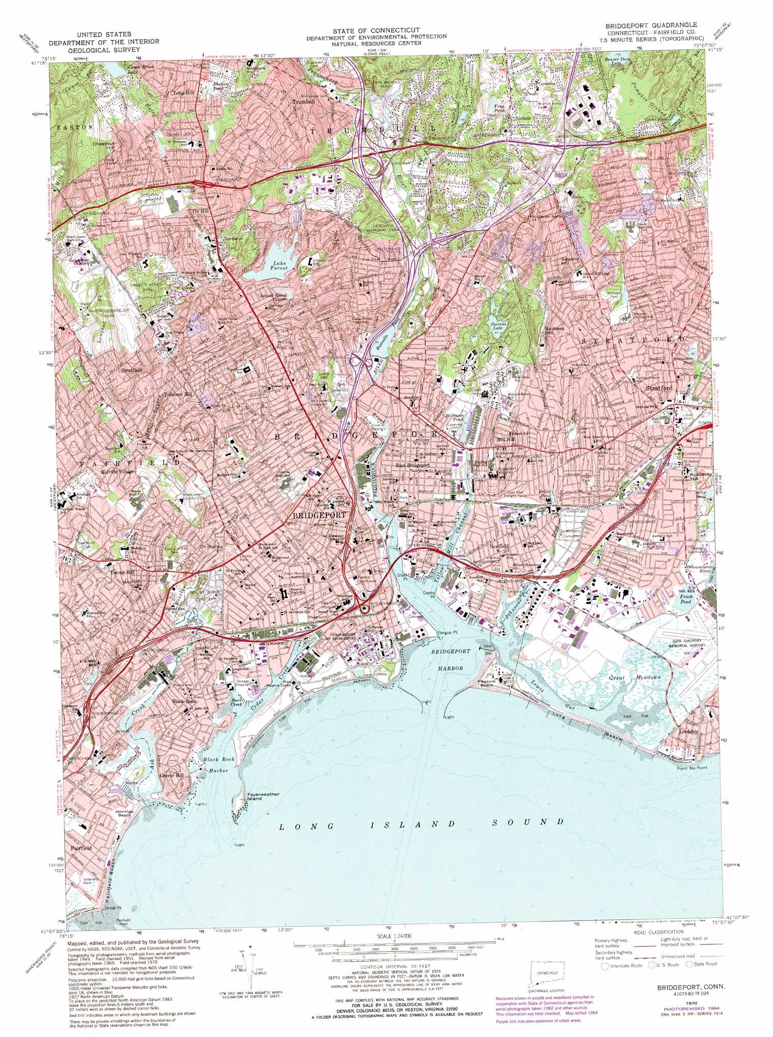
USGS Topo Quad 41073b2 - 1:24,000 scale
| Topo Map Name: | Bridgeport |
| USGS Topo Quad ID: | 41073b2 |
| Print Size: | ca. 21 1/4" wide x 27" high |
| Southeast Coordinates: | 41.125° N latitude / 73.125° W longitude |
| Map Center Coordinates: | 41.1875° N latitude / 73.1875° W longitude |
| U.S. State: | CT |
| Filename: | o41073b2.jpg |
| Download Map JPG Image: | Bridgeport topo map 1:24,000 scale |
| Map Type: | Topographic |
| Topo Series: | 7.5´ |
| Map Scale: | 1:24,000 |
| Source of Map Images: | United States Geological Survey (USGS) |
| Alternate Map Versions: |
Bridgeport CT 1951, updated 1959 Download PDF Buy paper map Bridgeport CT 1951, updated 1960 Download PDF Buy paper map Bridgeport CT 1960, updated 1963 Download PDF Buy paper map Bridgeport CT 1970, updated 1972 Download PDF Buy paper map Bridgeport CT 1970, updated 1984 Download PDF Buy paper map Bridgeport CT 1970, updated 1988 Download PDF Buy paper map Bridgeport CT 1970, updated 1988 Download PDF Buy paper map Bridgeport CT 2012 Download PDF Buy paper map Bridgeport CT 2015 Download PDF Buy paper map |
1:24,000 Topo Quads surrounding Bridgeport
Danbury |
Newtown |
Southbury |
Naugatuck |
Mount Carmel |
Bethel |
Botsford |
Long Hill |
Ansonia |
New Haven |
Norwalk North |
Westport |
Bridgeport |
Milford |
Woodmont |
Norwalk South |
Sherwood Point |
|||
Lloyd Harbor |
Northport |
Saint James |
Port Jefferson |
Middle Island |
> Back to 41073a1 at 1:100,000 scale
> Back to 41072a1 at 1:250,000 scale
> Back to U.S. Topo Maps home
Bridgeport topo map: Gazetteer
Bridgeport: Airports
Bridgeport Hospital Heliport elevation 26m 85′Chase Manhattan Bank of Connecticut Heliport elevation 64m 209′
Igor I Sikorsky Memorial Airport elevation 3m 9′
Medical Center Heliport elevation 41m 134′
Sikorsky Bridgeport Heliport elevation 6m 19′
Bridgeport: Bars
Penfield Reef elevation 0m 0′Point Rocks elevation 0m 0′
Bridgeport: Bays
Brewster Cove elevation 7m 22′Burr Creek elevation 0m 0′
Bridgeport: Beaches
Fairfield Beach elevation 2m 6′Jennings Beach elevation 0m 0′
Long Beach elevation 0m 0′
Long Beach elevation 4m 13′
Money Beach elevation 11m 36′
Pleasure Beach elevation 3m 9′
Seaside Beach elevation 0m 0′
Bridgeport: Bridges
Berkshire Bridge elevation 2m 6′Bridgeport Bridge elevation 0m 0′
Center Bridge elevation 1m 3′
Yellow Mill Bridge elevation 0m 0′
Bridgeport: Canals
Black Rock Entrance Channel elevation 0m 0′Bridgeport Entrance Channel elevation 0m 0′
Bridgeport: Capes
Battery Point elevation 6m 19′Black Rock Neck elevation 7m 22′
Cooks Point elevation 2m 6′
Fayerweather Point elevation -3m -10′
Long Beach Point elevation 3m 9′
Mather Point elevation 0m 0′
Park Point elevation 8m 26′
Point No Point elevation 0m 0′
Shoal Point elevation 0m 0′
Steel Point elevation 1m 3′
Tongue Point elevation 0m 0′
Bridgeport: Channels
Black Rock Reach elevation 0m 0′Break of the Beach (historical) elevation -3m -10′
Cedar Creek Reach elevation 0m 0′
Yellow Mill Channel elevation 0m 0′
Bridgeport: Crossings
Interchange 1 elevation 11m 36′Interchange 22 elevation 4m 13′
Interchange 23 elevation 7m 22′
Interchange 24 elevation 8m 26′
Interchange 25 elevation 4m 13′
Interchange 26 elevation 4m 13′
Interchange 27 elevation 11m 36′
Interchange 28 elevation 9m 29′
Interchange 29 elevation 11m 36′
Interchange 3 elevation 16m 52′
Interchange 30 elevation 3m 9′
Interchange 31 elevation 9m 29′
Interchange 32 elevation 7m 22′
Interchange 47 elevation 81m 265′
Interchange 48 elevation 97m 318′
Interchange 49 elevation 125m 410′
Interchange 5 elevation 14m 45′
Interchange 50 elevation 38m 124′
Interchange 51 elevation 76m 249′
Interchange 52 elevation 54m 177′
Interchange 6 elevation 28m 91′
Bridgeport: Dams
Beaver Dam Lake Dam elevation 35m 114′Bunnells Pond Dam elevation 10m 32′
Canoe Brook Lake Dam elevation 105m 344′
Canoe Brook Lake Dike elevation 105m 344′
Forest Lake Dam elevation 53m 173′
Island Brook Lagoon Dam elevation 50m 164′
Success Lake Dam elevation 14m 45′
Tongue Point Breakwater elevation 0m 0′
Bridgeport: Guts
Lewis Gut elevation 0m 0′Bridgeport: Harbors
Black Rock Harbor elevation 0m 0′Bridgeport Harbor elevation 0m 0′
Cedar Creek Harbor elevation 0m 0′
Bridgeport: Islands
Fayerweather Island elevation 1m 3′Bridgeport: Lakes
Brewsters Pond elevation 9m 29′Bruce Pond elevation 16m 52′
Chamberland Pond elevation 16m 52′
Cooks Pond elevation 33m 108′
Ehrsam Pond elevation 118m 387′
Frash Pond elevation 2m 6′
Frog Pond elevation 84m 275′
Island Brook Lagoon elevation 50m 164′
Seeleys Pond elevation 6m 19′
Stillman Pond elevation 12m 39′
Success Lake elevation 14m 45′
Bridgeport: Parks
Abraham Nichols Park elevation 88m 288′Aldo Park elevation 113m 370′
Barnum-Palliser Historic District elevation 8m 26′
Bassickville Historic District elevation 17m 55′
Beachwood Park elevation 23m 75′
Beardsley Park elevation 34m 111′
Beardsley Zoological Gardens elevation 32m 104′
Black Rock Gardens Historic District elevation 22m 72′
Black Rock Historic District elevation 15m 49′
Bridgeport Downtown North Historic District elevation 14m 45′
Bridgeport Downtown South Historic District elevation 14m 45′
City Hall Park elevation 20m 65′
Clinton Park elevation 3m 9′
Clover Field elevation 5m 16′
Davidow Park elevation 102m 334′
East Bridgeport Historic District elevation 11m 36′
East Main Street Historic District elevation 10m 32′
Eastside Park elevation 5m 16′
Elton Rogers Woodland Park elevation 60m 196′
Fairchild-Wheeler Park elevation 82m 269′
Gateway Village Historic District elevation 13m 42′
Glenwood Park elevation 9m 29′
Golden Hill Historic District elevation 11m 36′
Gould Manor Park elevation 16m 52′
High Park elevation 26m 85′
Island Brook Park elevation 107m 351′
Johnson Oak Park elevation 5m 16′
Kennedy Stadium elevation 16m 52′
Lafayett Park elevation 23m 75′
Lakeview Village Historic District elevation 14m 45′
Lilalyn Park elevation 37m 121′
Longfellow Park elevation 8m 26′
Low Park elevation 4m 13′
Maefair Court elevation 51m 167′
Marina Park Historic District elevation 9m 29′
McClevy Green elevation 14m 45′
Middlebrooks Park elevation 107m 351′
Newfield Park elevation 5m 16′
Nichols Farm Historic District elevation 86m 282′
Ninety Acres Park elevation 63m 206′
North End Park elevation 42m 137′
North Parade Ground (historical) elevation 12m 39′
Nothinagle Memorial Field elevation 93m 305′
Old Mill Green elevation 12m 39′
Paradise Green Park elevation 15m 49′
Park Square elevation 58m 190′
Pleasure Beach Park elevation 1m 3′
Remington City Historic District elevation 22m 72′
Remington Village Historic District elevation 17m 55′
Seaside Park elevation 8m 26′
Seaside Village Historic District elevation 9m 29′
Shoreline Star Greyhound Park and Entertainment Complex elevation 14m 45′
Sterling Park elevation 9m 29′
Stratford Center Historic District elevation 10m 32′
Success Park elevation 20m 65′
Svihra Park elevation 15m 49′
Tunxis Hill Park elevation 14m 45′
Twin Brooks Park elevation 24m 78′
Veterans Park elevation 46m 150′
Veterans Park elevation 6m 19′
Washington Park elevation 10m 32′
Water View Park elevation 0m 0′
Went Field elevation 9m 29′
West Side Park elevation 2m 6′
Wooster Park elevation 37m 121′
YMCA Park elevation 9m 29′
Bridgeport: Populated Places
Black Rock elevation 15m 49′Bridgeport elevation 1m 3′
Cupheag (historical) elevation 7m 22′
East Bridgeport elevation 0m 0′
Grover Hill elevation 25m 82′
Little Danbury elevation 2m 6′
Little Danbury (historical) elevation 4m 13′
Melville Village elevation 41m 134′
Mill Hill elevation 6m 19′
Newfield elevation 11m 36′
Nichols elevation 84m 275′
Ox Hill elevation 90m 295′
Schoonhoven Park elevation 14m 45′
Stratfield elevation 76m 249′
Stratford elevation 7m 22′
Toilsome Hill elevation 71m 232′
Trumbull elevation 71m 232′
Tunxis Hill elevation 54m 177′
Bridgeport: Post Offices
Bridgeport Post Office elevation 9m 29′Bridgeport: Reservoirs
Beaver Dam Lake elevation 35m 114′Bunnells Pond elevation 10m 32′
Canoe Brook Lake elevation 105m 344′
Horse Tavern Reservoir elevation 68m 223′
Lake Forest elevation 53m 173′
Moodys Mill Pond elevation 14m 45′
Thrushwood Lake elevation 59m 193′
Bridgeport: Streams
Ash Creek elevation 0m 0′Booth Hill Brook elevation 29m 95′
Bruce Brook elevation 0m 0′
Cemetery Pond Brook elevation 30m 98′
Horse Tavern Brook elevation 21m 68′
Island Brook elevation 8m 26′
Johnsons Creek elevation 0m 0′
Londons Brook elevation 23m 75′
Long Brook elevation 0m 0′
Pequonnock River elevation 0m 0′
Rooster River elevation 0m 0′
White Rock Creek elevation 0m 0′
Bridgeport: Summits
Academy Hill elevation 7m 22′Chestnut Hill elevation 141m 462′
Meetinghouse Hill elevation 17m 55′
Second Hill elevation 58m 190′
Success Hill elevation 14m 45′
Tunxis Hill elevation 49m 160′
Bridgeport: Swamps
Great Meadows elevation 0m 0′Bridgeport digital topo map on disk
Buy this Bridgeport topo map showing relief, roads, GPS coordinates and other geographical features, as a high-resolution digital map file on DVD:
New York, Vermont, Connecticut & Western Massachusetts
Buy digital topo maps: New York, Vermont, Connecticut & Western Massachusetts