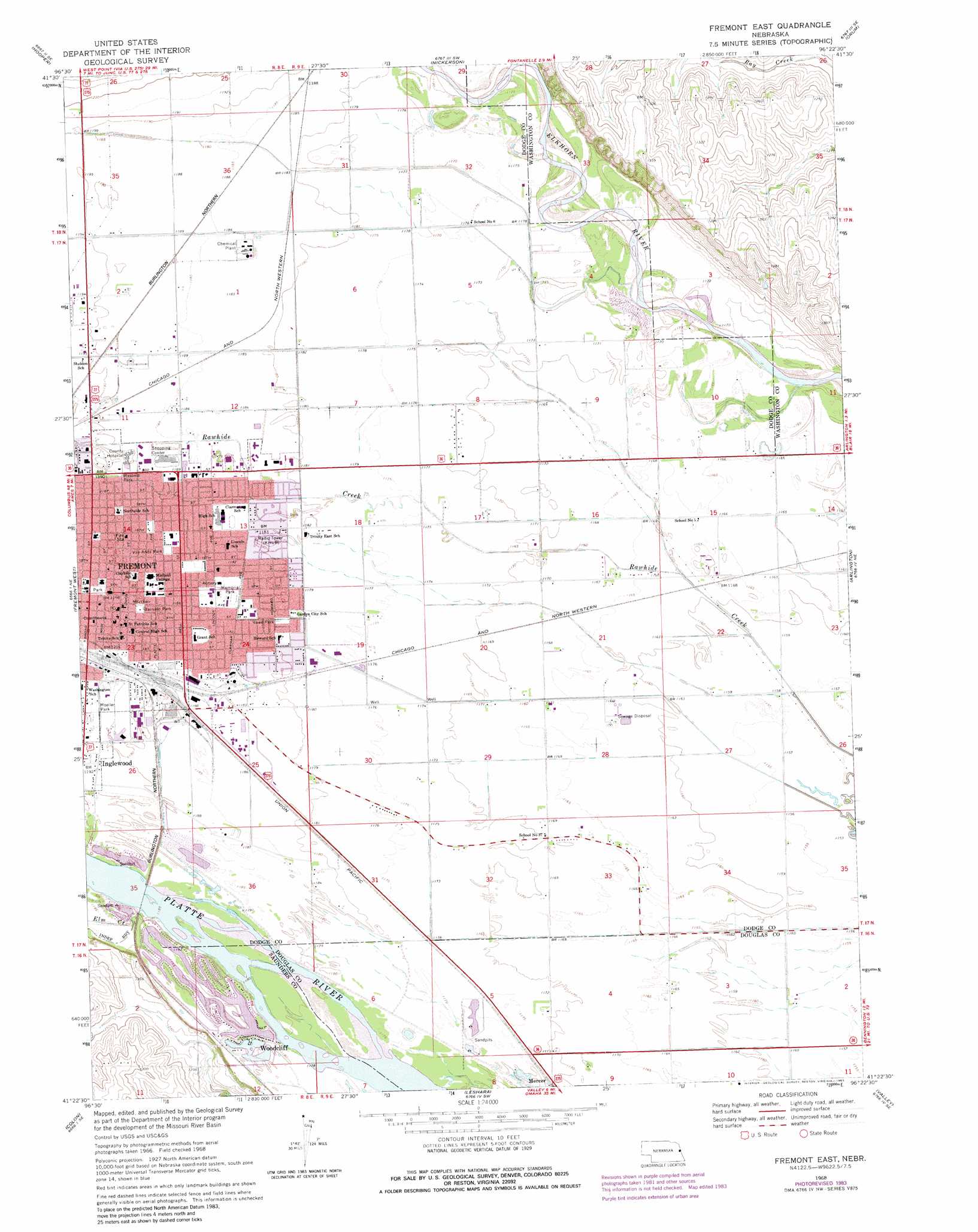
Fremont East Topo Map Nebraska
To zoom in, hover over the map of Fremont East
USGS Topo Quad 41096d4 - 1:24,000 scale
| Topo Map Name: | Fremont East |
| USGS Topo Quad ID: | 41096d4 |
| Print Size: | ca. 21 1/4" wide x 27" high |
| Southeast Coordinates: | 41.375° N latitude / 96.375° W longitude |
| Map Center Coordinates: | 41.4375° N latitude / 96.4375° W longitude |
| U.S. State: | NE |
| Filename: | O41096D4.jpg |
| Download Map JPG Image: | Fremont East topo map 1:24,000 scale |
| Map Type: | Topographic |
| Topo Series: | 7.5´ |
| Map Scale: | 1:24,000 |
| Source of Map Images: | United States Geological Survey (USGS) |
| Alternate Map Versions: |
Fremont East NE 1968, updated 1971 Download PDF Buy paper map Fremont East NE 1968, updated 1977 Download PDF Buy paper map Fremont East NE 1968, updated 1983 Download PDF Buy paper map Fremont East NE 2011 Download PDF Buy paper map Fremont East NE 2014 Download PDF Buy paper map |
1:24,000 Topo Quads surrounding Fremont East
Scribner |
Uehling |
Nickerson Nw |
Nickerson Ne |
Herman |
Scribner Sw |
Hooper |
Nickerson |
Orum |
Blair |
Malmo Nw |
Fremont West |
Fremont East |
Arlington |
Kennard |
Malmo |
Colon |
Leshara |
Valley |
Elkhorn |
Wahoo West |
Wahoo East |
Mead |
Wann |
Gretna |
> Back to 41096a1 at 1:100,000 scale
> Back to 41096a1 at 1:250,000 scale
> Back to U.S. Topo Maps home
Fremont East topo map: Gazetteer
Fremont East: Channels
Rawhide Creek (Old Channel) elevation 360m 1181′Fremont East: Parks
Barnard Park elevation 363m 1190′Buch Park elevation 360m 1181′
Buckridge Park elevation 360m 1181′
Clemmons Park elevation 360m 1181′
John C Fremont City Park elevation 361m 1184′
Masonic Park elevation 363m 1190′
Memorial Park elevation 360m 1181′
Midland Park elevation 362m 1187′
Moeller Park elevation 363m 1190′
Monnich Park elevation 363m 1190′
Platte River History Historical Marker elevation 357m 1171′
Ruwe Park elevation 360m 1181′
Van Anda Park elevation 362m 1187′
Victory Bell elevation 363m 1190′
Fremont East: Populated Places
Fremont elevation 365m 1197′Paradise Estates elevation 363m 1190′
Regency II Mobile Home Park elevation 363m 1190′
Woodcliff elevation 360m 1181′
Fremont East: Post Offices
Fremont Post Office elevation 363m 1190′Fremont East: Streams
Elm Creek elevation 363m 1190′Fremont East digital topo map on disk
Buy this Fremont East topo map showing relief, roads, GPS coordinates and other geographical features, as a high-resolution digital map file on DVD: