Baggs Topo Map Wyoming
To zoom in, hover over the map of Baggs
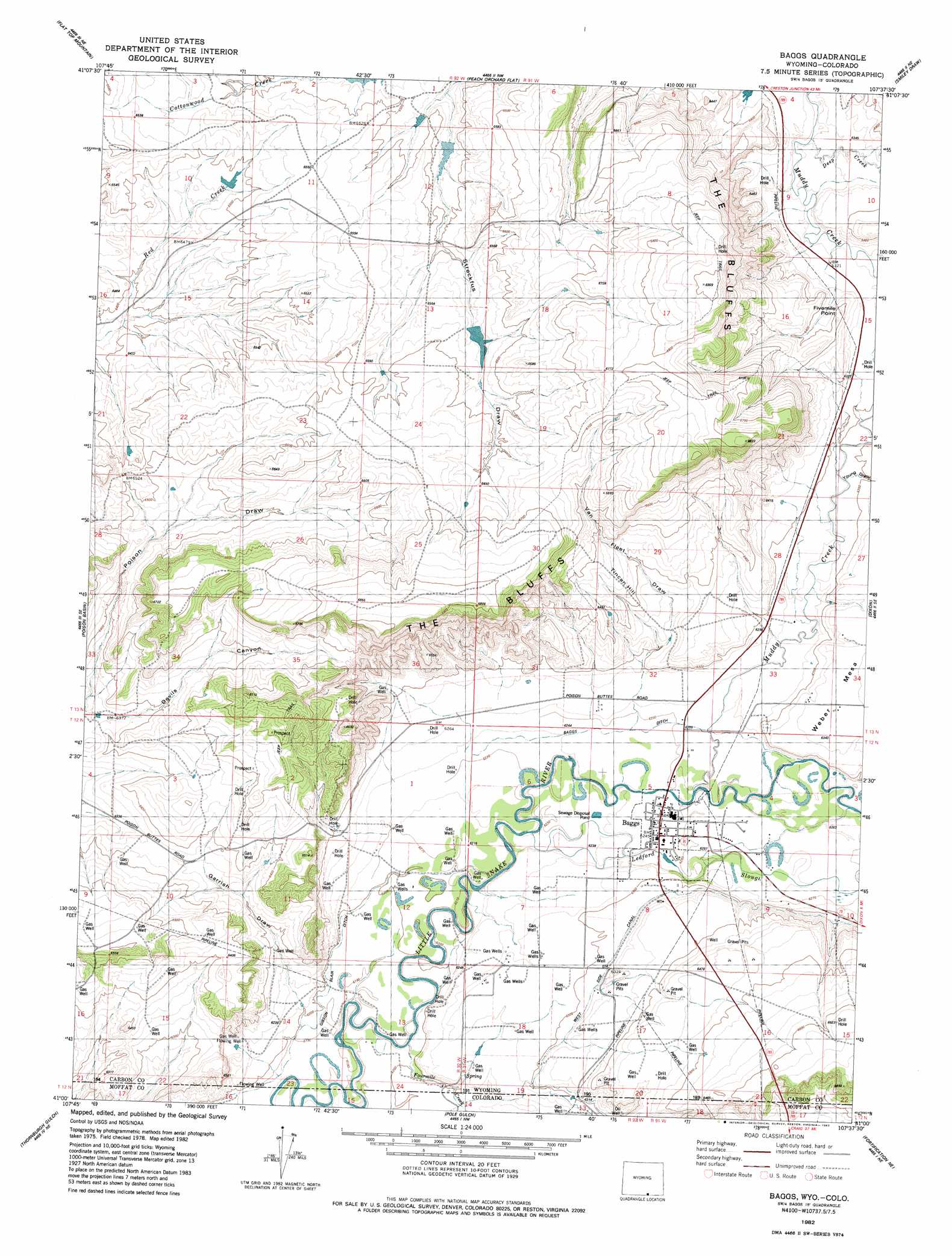
USGS Topo Quad 41107a6 - 1:24,000 scale
| Topo Map Name: | Baggs |
| USGS Topo Quad ID: | 41107a6 |
| Print Size: | ca. 21 1/4" wide x 27" high |
| Southeast Coordinates: | 41° N latitude / 107.625° W longitude |
| Map Center Coordinates: | 41.0625° N latitude / 107.6875° W longitude |
| U.S. States: | WY, CO |
| Filename: | o41107a6.jpg |
| Download Map JPG Image: | Baggs topo map 1:24,000 scale |
| Map Type: | Topographic |
| Topo Series: | 7.5´ |
| Map Scale: | 1:24,000 |
| Source of Map Images: | United States Geological Survey (USGS) |
| Alternate Map Versions: |
Baggs SW WY 1975, updated 1978 Download PDF Buy paper map Baggs WY 1982, updated 1983 Download PDF Buy paper map Baggs WY 2010 Download PDF Buy paper map Baggs WY 2012 Download PDF Buy paper map Baggs WY 2015 Download PDF Buy paper map |
1:24,000 Topo Quads surrounding Baggs
South Barrel Spring |
Mexican Flats |
Blue Gap |
Garden Gulch |
Ketchum Buttes |
Dripping Rock Spring |
Flat Top Mountain |
Peach Orchard Flat |
Smiley Draw |
Browns Hill |
Mcpherson Springs |
Poison Basin |
Baggs |
Dixon |
Savery |
Bighole Butte |
Thornburgh Gulch |
Pole Gulch |
Fortification Ne |
Bakers Peak |
Mayberry Spring |
Great Divide |
East Timberlake Creek |
Fortification |
Freeman Reservoir |
> Back to 41107a1 at 1:100,000 scale
> Back to 41106a1 at 1:250,000 scale
> Back to U.S. Topo Maps home
Baggs topo map: Gazetteer
Baggs: Canals
Baggs Ditch elevation 1902m 6240′Gibson Blair Ditch elevation 1891m 6204′
West Side Canal elevation 1929m 6328′
Baggs: Capes
Fivemile Point elevation 1949m 6394′Baggs: Cliffs
The Bluffs elevation 1989m 6525′Baggs: Dams
Detention Dam 1392 Number 2 elevation 1973m 6473′Detention Dam 1392 Number 4 elevation 1980m 6496′
Baggs: Populated Places
Baggs elevation 1904m 6246′Baggs: Reservoirs
Dead Horse Reservoir elevation 1952m 6404′Detention Dam 1392 Number 2 elevation 1973m 6473′
Detention Dam 1392 Number 4 elevation 1980m 6496′
Baggs: Streams
Deep Creek elevation 1928m 6325′Fourmile Creek elevation 1889m 6197′
Fourmile Creek elevation 1888m 6194′
Ledford Slough elevation 1897m 6223′
Muddy Creek elevation 1904m 6246′
Baggs: Summits
Tincan Hill elevation 1963m 6440′Weber Mesa elevation 1938m 6358′
Baggs: Valleys
Devils Canyon elevation 1941m 6368′Garrish Draw elevation 1891m 6204′
Streckfus Draw elevation 1963m 6440′
Van Fleet Draw elevation 1916m 6286′
Baggs digital topo map on disk
Buy this Baggs topo map showing relief, roads, GPS coordinates and other geographical features, as a high-resolution digital map file on DVD:
Eastern Wyoming & Western South Dakota
Buy digital topo maps: Eastern Wyoming & Western South Dakota