Cold Spring Mountain Topo Map California
To zoom in, hover over the map of Cold Spring Mountain
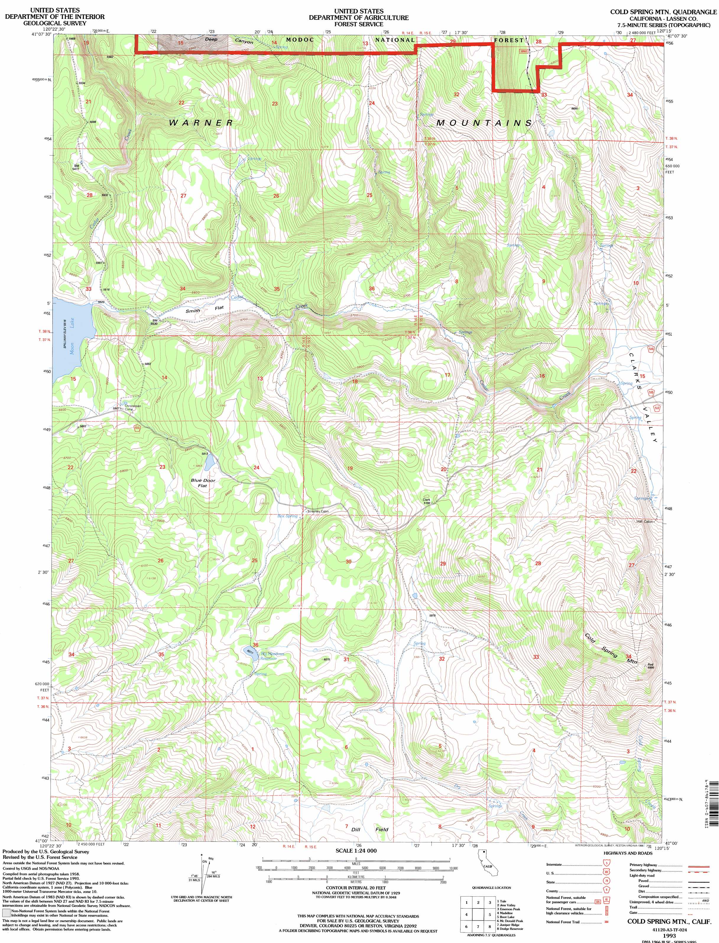
USGS Topo Quad 41120a3 - 1:24,000 scale
| Topo Map Name: | Cold Spring Mountain |
| USGS Topo Quad ID: | 41120a3 |
| Print Size: | ca. 21 1/4" wide x 27" high |
| Southeast Coordinates: | 41° N latitude / 120.25° W longitude |
| Map Center Coordinates: | 41.0625° N latitude / 120.3125° W longitude |
| U.S. State: | CA |
| Filename: | o41120a3.jpg |
| Download Map JPG Image: | Cold Spring Mountain topo map 1:24,000 scale |
| Map Type: | Topographic |
| Topo Series: | 7.5´ |
| Map Scale: | 1:24,000 |
| Source of Map Images: | United States Geological Survey (USGS) |
| Alternate Map Versions: |
Cold Spring Mtn CA 1962, updated 1964 Download PDF Buy paper map Cold Spring Mtn CA 1962, updated 1964 Download PDF Buy paper map Cold Spring Mtn CA 1962, updated 1972 Download PDF Buy paper map Cold Spring Mtn CA 1962, updated 1983 Download PDF Buy paper map Cold Spring Mtn CA 1993, updated 1996 Download PDF Buy paper map Cold Spring Mountain CA 2012 Download PDF Buy paper map Cold Spring Mountain CA 2015 Download PDF Buy paper map |
| FStopo: | US Forest Service topo Cold Spring Mountain is available: Download FStopo PDF Download FStopo TIF |
1:24,000 Topo Quads surrounding Cold Spring Mountain
Bayley |
Little Juniper Reservoir |
Soup Creek |
Eagle Peak |
Eagleville |
Likely |
Tule Mountain |
Jess Valley |
Emerson Peak |
Snake Lake |
Holbrook Canyon |
Madeline |
Cold Spring Mountain |
Boot Lake |
Little Hat Mountain |
Anderson Mountain |
Mcdonald Peak |
Juniper Ridge |
Dodge Reservoir |
Buckhorn Lake |
Cleghorn Flat |
Termo |
Ravendale |
Observation Peak |
Buckhorn Canyon |
> Back to 41120a1 at 1:100,000 scale
> Back to 41120a1 at 1:250,000 scale
> Back to U.S. Topo Maps home
Cold Spring Mountain topo map: Gazetteer
Cold Spring Mountain: Basins
Clarks Valley elevation 1805m 5921′Cold Spring Mountain: Dams
Tule Lake 1249-004 Dam elevation 1683m 5521′Cold Spring Mountain: Flats
Blue Door Flat elevation 1774m 5820′Dill Field elevation 1816m 5958′
Smith Flat elevation 1690m 5544′
Cold Spring Mountain: Reservoirs
Big Meadows Reservoir elevation 1854m 6082′Moon Lake elevation 1683m 5521′
Cold Spring Mountain: Springs
Box Spring elevation 1817m 5961′Cold Spring Mountain: Summits
Cold Spring Mountain elevation 2129m 6984′Cold Spring Mountain digital topo map on disk
Buy this Cold Spring Mountain topo map showing relief, roads, GPS coordinates and other geographical features, as a high-resolution digital map file on DVD: