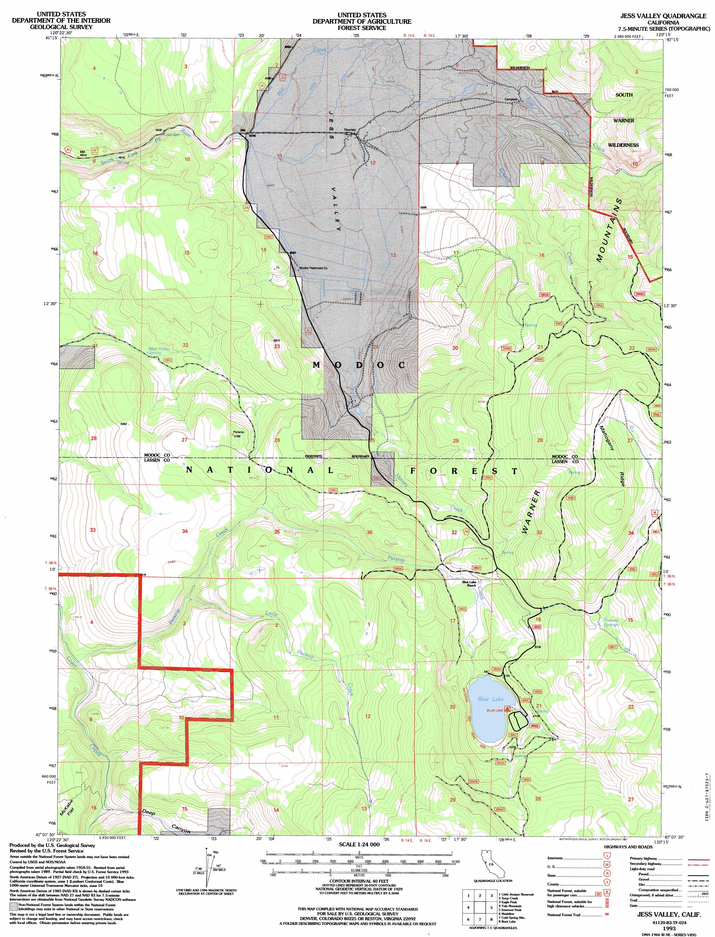
Jess Valley Topo Map California
To zoom in, hover over the map of Jess Valley
USGS Topo Quad 41120b3 - 1:24,000 scale
| Topo Map Name: | Jess Valley |
| USGS Topo Quad ID: | 41120b3 |
| Print Size: | ca. 21 1/4" wide x 27" high |
| Southeast Coordinates: | 41.125° N latitude / 120.25° W longitude |
| Map Center Coordinates: | 41.1875° N latitude / 120.3125° W longitude |
| U.S. State: | CA |
| Filename: | o41120b3.jpg |
| Download Map JPG Image: | Jess Valley topo map 1:24,000 scale |
| Map Type: | Topographic |
| Topo Series: | 7.5´ |
| Map Scale: | 1:24,000 |
| Source of Map Images: | United States Geological Survey (USGS) |
| Alternate Map Versions: |
Jess Valley CA 1962, updated 1964 Download PDF Buy paper map Jess Valley CA 1962, updated 1972 Download PDF Buy paper map Jess Valley CA 1962, updated 1983 Download PDF Buy paper map Jess Valley CA 1962, updated 1984 Download PDF Buy paper map Jess Valley CA 1993, updated 1997 Download PDF Buy paper map Jess Valley CA 2012 Download PDF Buy paper map Jess Valley CA 2015 Download PDF Buy paper map |
| FStopo: | US Forest Service topo Jess Valley is available: Download FStopo PDF Download FStopo TIF |
1:24,000 Topo Quads surrounding Jess Valley
Alturas |
Dorris Reservoir |
Shields Creek |
Warren Peak |
Hansen Island |
Bayley |
Little Juniper Reservoir |
Soup Creek |
Eagle Peak |
Eagleville |
Likely |
Tule Mountain |
Jess Valley |
Emerson Peak |
Snake Lake |
Holbrook Canyon |
Madeline |
Cold Spring Mountain |
Boot Lake |
Little Hat Mountain |
Anderson Mountain |
Mcdonald Peak |
Juniper Ridge |
Dodge Reservoir |
Buckhorn Lake |
> Back to 41120a1 at 1:100,000 scale
> Back to 41120a1 at 1:250,000 scale
> Back to U.S. Topo Maps home
Jess Valley topo map: Gazetteer
Jess Valley: Dams
Blue Lake Dam elevation 1848m 6062′Jess Valley: Flats
McKabe Flat elevation 1653m 5423′Jess Valley: Populated Places
Campbell elevation 1613m 5291′Flourney elevation 1570m 5150′
Jess Valley: Reservoirs
Blue Lake elevation 1848m 6062′Jess Valley: Ridges
Mahogany Ridge elevation 2222m 7290′Jess Valley: Springs
Parsnip Springs elevation 1958m 6423′West Valley Spring elevation 1545m 5068′
Jess Valley: Streams
Coyote Creek elevation 1538m 5045′East Creek elevation 1544m 5065′
Harvey Creek elevation 1601m 5252′
Little Parsnip Creek elevation 1584m 5196′
Mill Creek elevation 1543m 5062′
Parsnip Creek elevation 1490m 4888′
Jess Valley: Valleys
Deep Canyon elevation 1560m 5118′Jess Valley elevation 1536m 5039′
Jess Valley digital topo map on disk
Buy this Jess Valley topo map showing relief, roads, GPS coordinates and other geographical features, as a high-resolution digital map file on DVD: