Dorris Reservoir Topo Map California
To zoom in, hover over the map of Dorris Reservoir
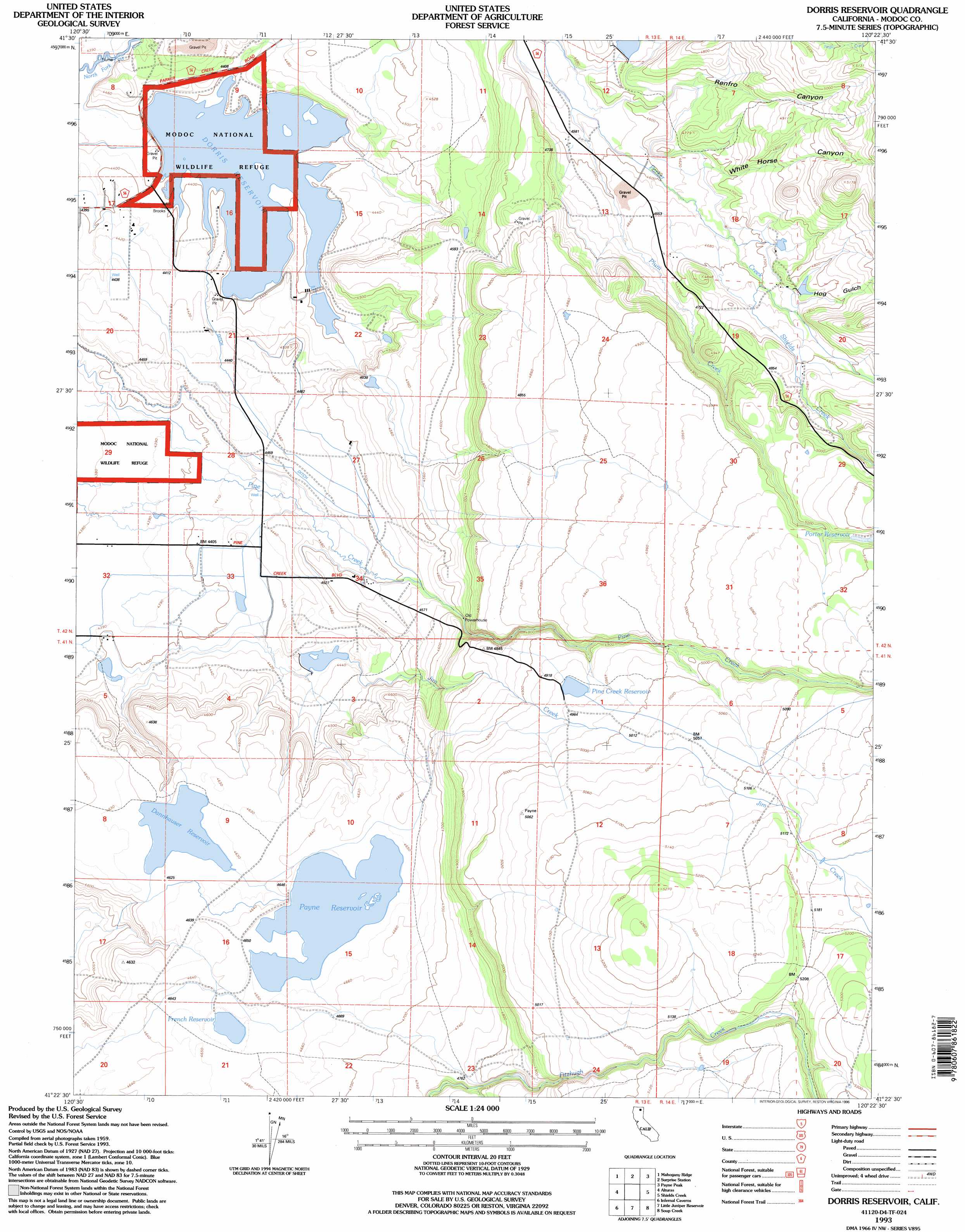
USGS Topo Quad 41120d4 - 1:24,000 scale
| Topo Map Name: | Dorris Reservoir |
| USGS Topo Quad ID: | 41120d4 |
| Print Size: | ca. 21 1/4" wide x 27" high |
| Southeast Coordinates: | 41.375° N latitude / 120.375° W longitude |
| Map Center Coordinates: | 41.4375° N latitude / 120.4375° W longitude |
| U.S. State: | CA |
| Filename: | o41120d4.jpg |
| Download Map JPG Image: | Dorris Reservoir topo map 1:24,000 scale |
| Map Type: | Topographic |
| Topo Series: | 7.5´ |
| Map Scale: | 1:24,000 |
| Source of Map Images: | United States Geological Survey (USGS) |
| Alternate Map Versions: |
Dorris Reservoir CA 1963, updated 1965 Download PDF Buy paper map Dorris Reservoir CA 1963, updated 1971 Download PDF Buy paper map Dorris Reservoir CA 1963, updated 1971 Download PDF Buy paper map Dorris Reservoir CA 1963, updated 1971 Download PDF Buy paper map Dorris Reservoir CA 1963, updated 1979 Download PDF Buy paper map Dorris Reservoir CA 1963, updated 1983 Download PDF Buy paper map Dorris Reservoir CA 1993, updated 1996 Download PDF Buy paper map Dorris Reservoir CA 2012 Download PDF Buy paper map Dorris Reservoir CA 2015 Download PDF Buy paper map |
| FStopo: | US Forest Service topo Dorris Reservoir is available: Download FStopo PDF Download FStopo TIF |
1:24,000 Topo Quads surrounding Dorris Reservoir
Whittemore Ridge |
Dead Horse Reservoir |
Lauer Reservoir |
Davis Creek |
Lake City |
Big Sage Reservoir |
Mahogany Ridge |
Surprise |
Payne Peak |
Cedarville |
Rattlesnake Butte |
Alturas |
Dorris Reservoir |
Shields Creek |
Warren Peak |
Graven Ridge |
Bayley |
Little Juniper Reservoir |
Soup Creek |
Eagle Peak |
Knox Mountain |
Likely |
Tule Mountain |
Jess Valley |
Emerson Peak |
> Back to 41120a1 at 1:100,000 scale
> Back to 41120a1 at 1:250,000 scale
> Back to U.S. Topo Maps home
Dorris Reservoir topo map: Gazetteer
Dorris Reservoir: Dams
Dannhauser 161 Dam elevation 1411m 4629′Dorris Dam elevation 1341m 4399′
Payne 143 Dam elevation 1415m 4642′
Upper Pasture 161-002 Dam elevation 1349m 4425′
Dorris Reservoir: Reservoirs
Dannhauser Reservoir elevation 1410m 4625′Dorris Reservoir elevation 1341m 4399′
French Reservoir elevation 1416m 4645′
Payne Reservoir elevation 1415m 4642′
Pine Creek Reservoir elevation 1509m 4950′
Porter Reservoir elevation 1528m 5013′
Dorris Reservoir: Streams
Plum Creek elevation 1392m 4566′Shields Creek elevation 1434m 4704′
Dorris Reservoir: Valleys
Hog Gulch elevation 1444m 4737′Renfro Canyon elevation 1402m 4599′
White Horse Canyon elevation 1416m 4645′
Dorris Reservoir digital topo map on disk
Buy this Dorris Reservoir topo map showing relief, roads, GPS coordinates and other geographical features, as a high-resolution digital map file on DVD: