Wildlife Draw West Topo Map Wyoming
To zoom in, hover over the map of Wildlife Draw West
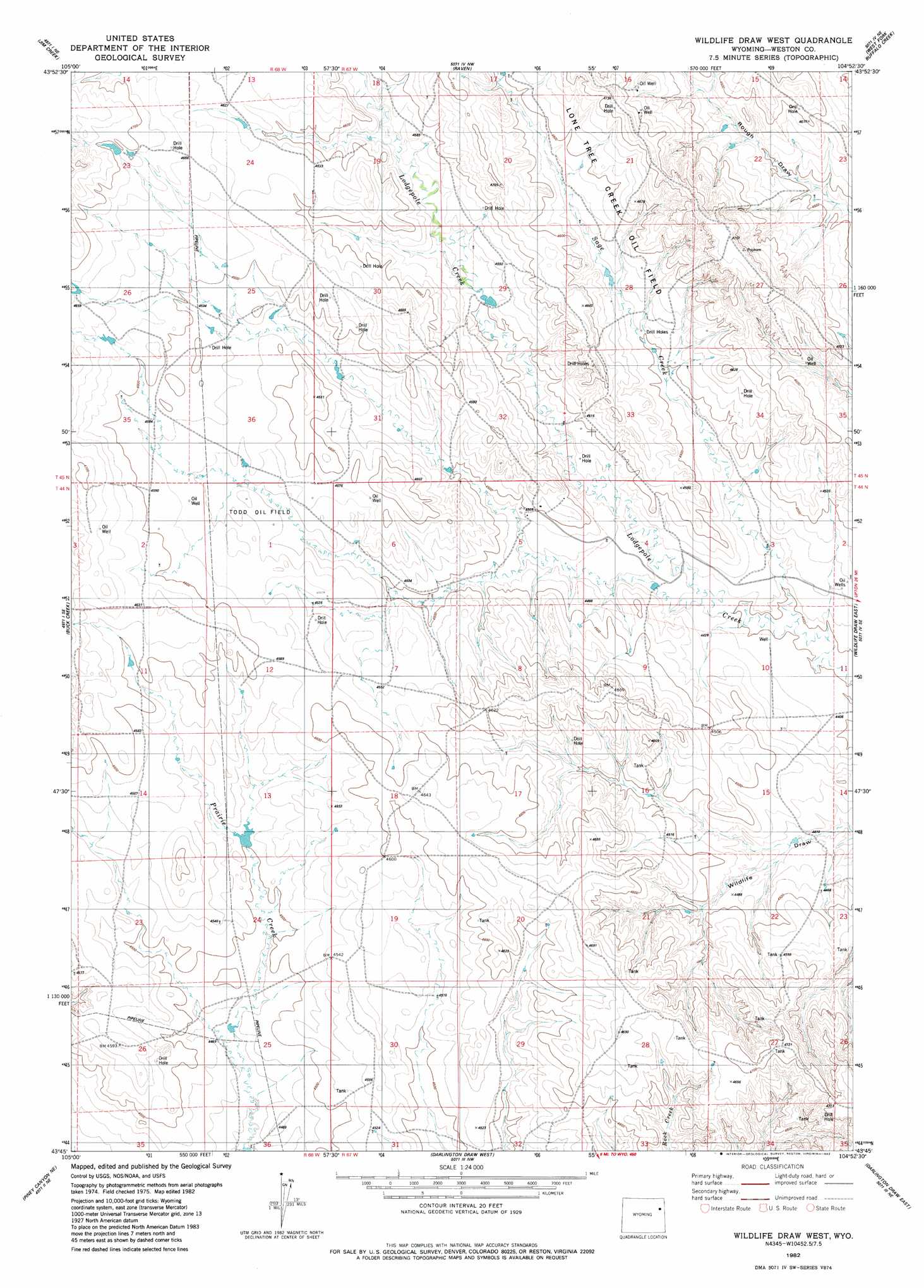
USGS Topo Quad 43104g8 - 1:24,000 scale
| Topo Map Name: | Wildlife Draw West |
| USGS Topo Quad ID: | 43104g8 |
| Print Size: | ca. 21 1/4" wide x 27" high |
| Southeast Coordinates: | 43.75° N latitude / 104.875° W longitude |
| Map Center Coordinates: | 43.8125° N latitude / 104.9375° W longitude |
| U.S. State: | WY |
| Filename: | o43104g8.jpg |
| Download Map JPG Image: | Wildlife Draw West topo map 1:24,000 scale |
| Map Type: | Topographic |
| Topo Series: | 7.5´ |
| Map Scale: | 1:24,000 |
| Source of Map Images: | United States Geological Survey (USGS) |
| Alternate Map Versions: |
Wildlife Draw West WY 1982, updated 1982 Download PDF Buy paper map Wildlife Draw West WY 2012 Download PDF Buy paper map Wildlife Draw West WY 2015 Download PDF Buy paper map |
| FStopo: | US Forest Service topo Wildlife Draw West is available: Download FStopo PDF Download FStopo TIF |
1:24,000 Topo Quads surrounding Wildlife Draw West
Whitetail Creek |
Whitetail Creek Se |
Cedar Draw |
Soda Butte |
Upton West |
Rough Creek |
Jim Creek |
Raven |
West Fork Buffalo Creek |
Sheep Canyon Creek West |
Open A Ranch |
Buck Creek |
Wildlife Draw West |
Wildlife Draw East |
Fairview |
Piney Canyon Nw |
Piney Canyon Ne |
Darlington Draw West |
Darlington Draw East |
Clareton |
Piney Canyon Sw |
Piney Canyon Se |
Lion Creek |
Poddy Creek |
The Nose West |
> Back to 43104e1 at 1:100,000 scale
> Back to 43104a1 at 1:250,000 scale
> Back to U.S. Topo Maps home
Wildlife Draw West topo map: Gazetteer
Wildlife Draw West: Dams
S Lodge Pole Number 1 Dam elevation 1358m 4455′Todd Detention Dam elevation 1380m 4527′
Wildlife Draw West: Oilfields
Lone Tree Oil Field elevation 1398m 4586′Todd Oil Field elevation 1397m 4583′
Wildlife Draw West: Reservoirs
S Lodge Pole Number 1 Reservoir elevation 1358m 4455′Todd Detention Dam Reservoir elevation 1380m 4527′
Wildlife Draw West: Streams
Sage Creek elevation 1341m 4399′Wildlife Draw West digital topo map on disk
Buy this Wildlife Draw West topo map showing relief, roads, GPS coordinates and other geographical features, as a high-resolution digital map file on DVD:
Eastern Wyoming & Western South Dakota
Buy digital topo maps: Eastern Wyoming & Western South Dakota