Star Hope Mine Topo Map Idaho
To zoom in, hover over the map of Star Hope Mine
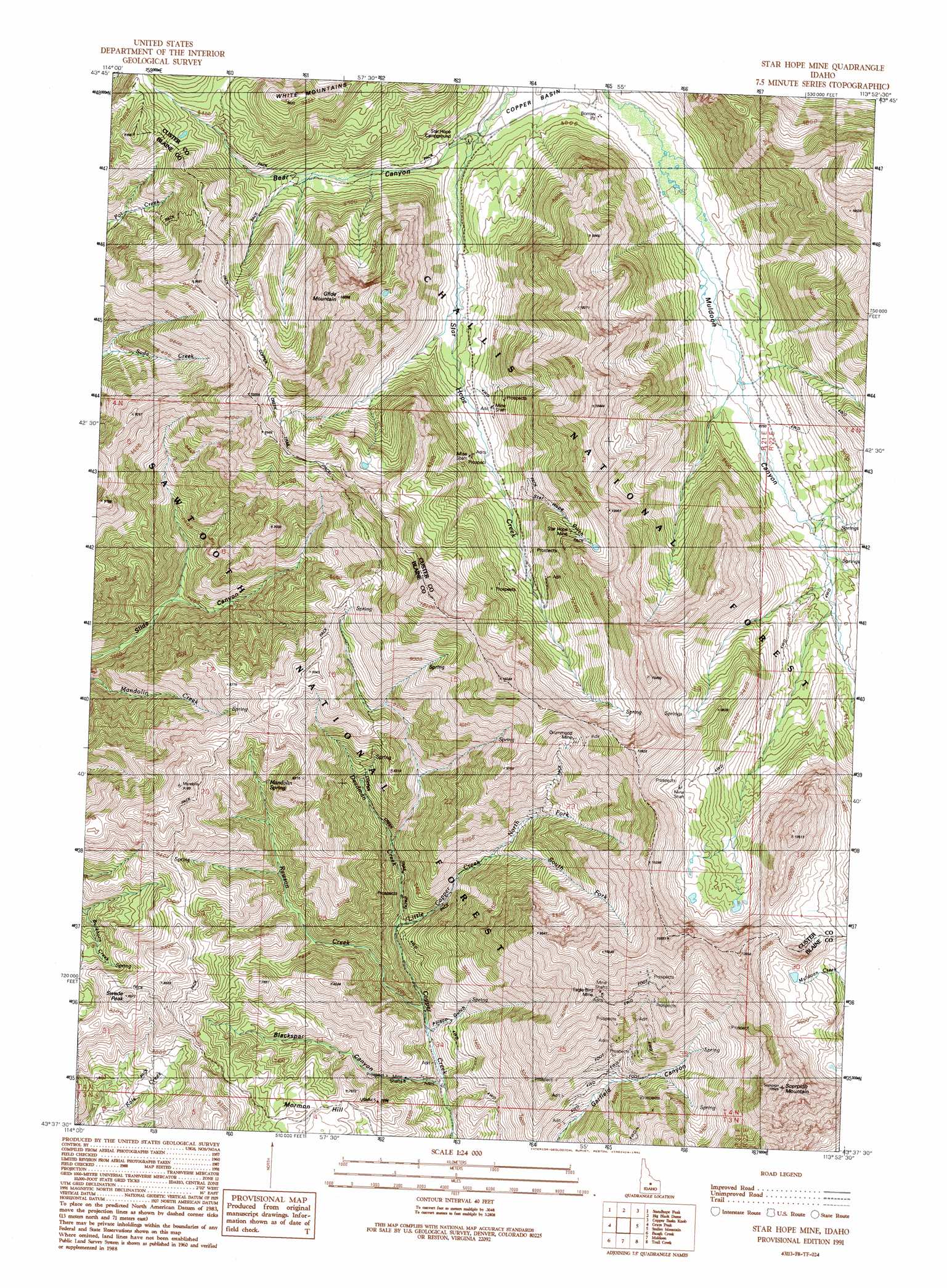
USGS Topo Quad 43113f8 - 1:24,000 scale
| Topo Map Name: | Star Hope Mine |
| USGS Topo Quad ID: | 43113f8 |
| Print Size: | ca. 21 1/4" wide x 27" high |
| Southeast Coordinates: | 43.625° N latitude / 113.875° W longitude |
| Map Center Coordinates: | 43.6875° N latitude / 113.9375° W longitude |
| U.S. State: | ID |
| Filename: | o43113f8.jpg |
| Download Map JPG Image: | Star Hope Mine topo map 1:24,000 scale |
| Map Type: | Topographic |
| Topo Series: | 7.5´ |
| Map Scale: | 1:24,000 |
| Source of Map Images: | United States Geological Survey (USGS) |
| Alternate Map Versions: |
Star Hope Mine ID 1991, updated 1991 Download PDF Buy paper map Star Hope Mine ID 2011 Download PDF Buy paper map Star Hope Mine ID 2013 Download PDF Buy paper map |
| FStopo: | US Forest Service topo Star Hope Mine is available: Download FStopo PDF Download FStopo TIF |
1:24,000 Topo Quads surrounding Star Hope Mine
Herd Peak |
Harry Canyon |
Porphyry Peak |
Lehman Butte |
Mackay Reservoir |
Phi Kappa Mountain |
Standhope Peak |
Big Black Dome |
Copper Basin Knob |
Shelly Mountain |
Hyndman Peak |
Grays Peak |
Star Hope Mine |
Smiley Mountain |
Miller Peak |
Baugh Creek Sw |
Baugh Creek |
Muldoon |
Trail Creek |
Blizzard Mountain North |
Seamans Creek |
Little Wood River Reservoir |
Lake Hills |
Fish Creek Reservoir |
Blizzard Mountain South |
> Back to 43113e1 at 1:100,000 scale
> Back to 43112a1 at 1:250,000 scale
> Back to U.S. Topo Maps home
Star Hope Mine topo map: Gazetteer
Star Hope Mine: Mines
Drummond Mine elevation 2792m 9160′Eagle Bird Mine elevation 2878m 9442′
Star Hope Mine elevation 2813m 9229′
Star Hope Mine: Ranges
White Mountains elevation 2926m 9599′Star Hope Mine: Springs
Mandolin Spring elevation 2418m 7933′Star Hope Mine: Streams
Deadman Creek elevation 2167m 7109′Little Copper Creek elevation 2143m 7030′
North Fork Little Copper Creek elevation 2290m 7513′
Rawson Creek elevation 2072m 6797′
South Fork Little Copper Creek elevation 2300m 7545′
Star Hope Mine: Summits
Glide Mountain elevation 3101m 10173′Mormon Hill elevation 2298m 7539′
Pioneer Mountain elevation 3136m 10288′
Scorpion Mountain elevation 3170m 10400′
Swede Peak elevation 2589m 8494′
Star Hope Mine: Trails
Copper Creek Trail elevation 2855m 9366′Star Hope Mine: Valleys
Bear Canyon elevation 2406m 7893′Blackspar Canyon elevation 2064m 6771′
Frisco Gulch elevation 2072m 6797′
Star Hope Gulch elevation 2547m 8356′
Star Hope Mine digital topo map on disk
Buy this Star Hope Mine topo map showing relief, roads, GPS coordinates and other geographical features, as a high-resolution digital map file on DVD: