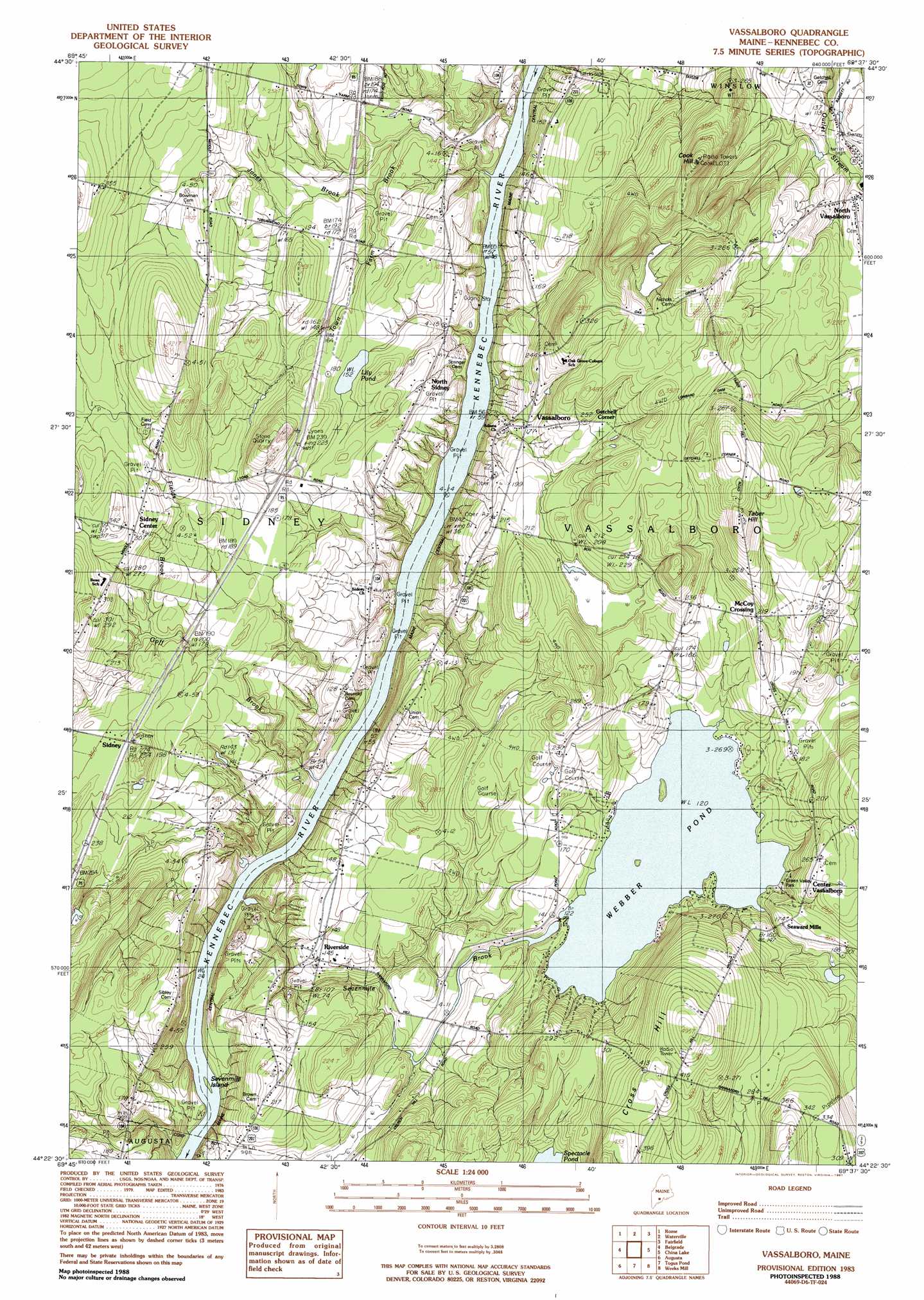
Vassalboro Topo Map Maine
To zoom in, hover over the map of Vassalboro
USGS Topo Quad 44069d6 - 1:24,000 scale
| Topo Map Name: | Vassalboro |
| USGS Topo Quad ID: | 44069d6 |
| Print Size: | ca. 21 1/4" wide x 27" high |
| Southeast Coordinates: | 44.375° N latitude / 69.625° W longitude |
| Map Center Coordinates: | 44.4375° N latitude / 69.6875° W longitude |
| U.S. State: | ME |
| Filename: | o44069d6.jpg |
| Download Map JPG Image: | Vassalboro topo map 1:24,000 scale |
| Map Type: | Topographic |
| Topo Series: | 7.5´ |
| Map Scale: | 1:24,000 |
| Source of Map Images: | United States Geological Survey (USGS) |
| Alternate Map Versions: |
Vassalboro NW ME 1975, updated 1980 Download PDF Buy paper map Vassalboro ME 1983, updated 1983 Download PDF Buy paper map Vassalboro ME 1983, updated 1991 Download PDF Buy paper map Vassalboro ME 2011 Download PDF Buy paper map Vassalboro ME 2014 Download PDF Buy paper map |
1:24,000 Topo Quads surrounding Vassalboro
Mercer |
Norridgewock |
Hinckley |
Clinton |
Burnham |
Belgrade Lakes |
Rome |
Waterville |
Fairfield |
Albion |
Readfield |
Belgrade |
Vassalboro |
China Lake |
Palermo |
Winthrop |
Augusta |
Togus Pond |
Weeks Mills |
Razorville |
Purgatory |
Gardiner |
East Pittston |
North Whitefield |
Jefferson |
> Back to 44069a1 at 1:100,000 scale
> Back to 44068a1 at 1:250,000 scale
> Back to U.S. Topo Maps home
Vassalboro topo map: Gazetteer
Vassalboro: Dams
Seven Mile Brook Dam elevation 33m 108′Webber Pond Dam elevation 38m 124′
Vassalboro: Islands
Sevenmile Island elevation 7m 22′Vassalboro: Lakes
Lily Pond elevation 46m 150′Vassalboro: Parks
Green Valley Park elevation 40m 131′Vassalboro: Populated Places
Center Vassalboro elevation 85m 278′Getchell Corner elevation 72m 236′
McCoy Crossing elevation 66m 216′
North Sidney elevation 42m 137′
Riverside elevation 43m 141′
Seaward Mills elevation 54m 177′
Sidney elevation 52m 170′
Vassalboro elevation 53m 173′
Vassalboro: Reservoirs
Seven Mile Brook elevation 33m 108′Webber Pond elevation 38m 124′
Vassalboro: Streams
Bog Brook elevation 58m 190′Fields Brook elevation 58m 190′
Goff Brook elevation 7m 22′
Jones Brook elevation 41m 134′
Sevenmile Brook elevation 7m 22′
Town Farm Brook elevation 10m 32′
Vassalboro: Summits
Cook Hill elevation 142m 465′Cross Hill elevation 151m 495′
Taber Hill elevation 131m 429′
Vassalboro digital topo map on disk
Buy this Vassalboro topo map showing relief, roads, GPS coordinates and other geographical features, as a high-resolution digital map file on DVD:
Maine, New Hampshire, Rhode Island & Eastern Massachusetts
Buy digital topo maps: Maine, New Hampshire, Rhode Island & Eastern Massachusetts