Louisville Topo Map New York
To zoom in, hover over the map of Louisville
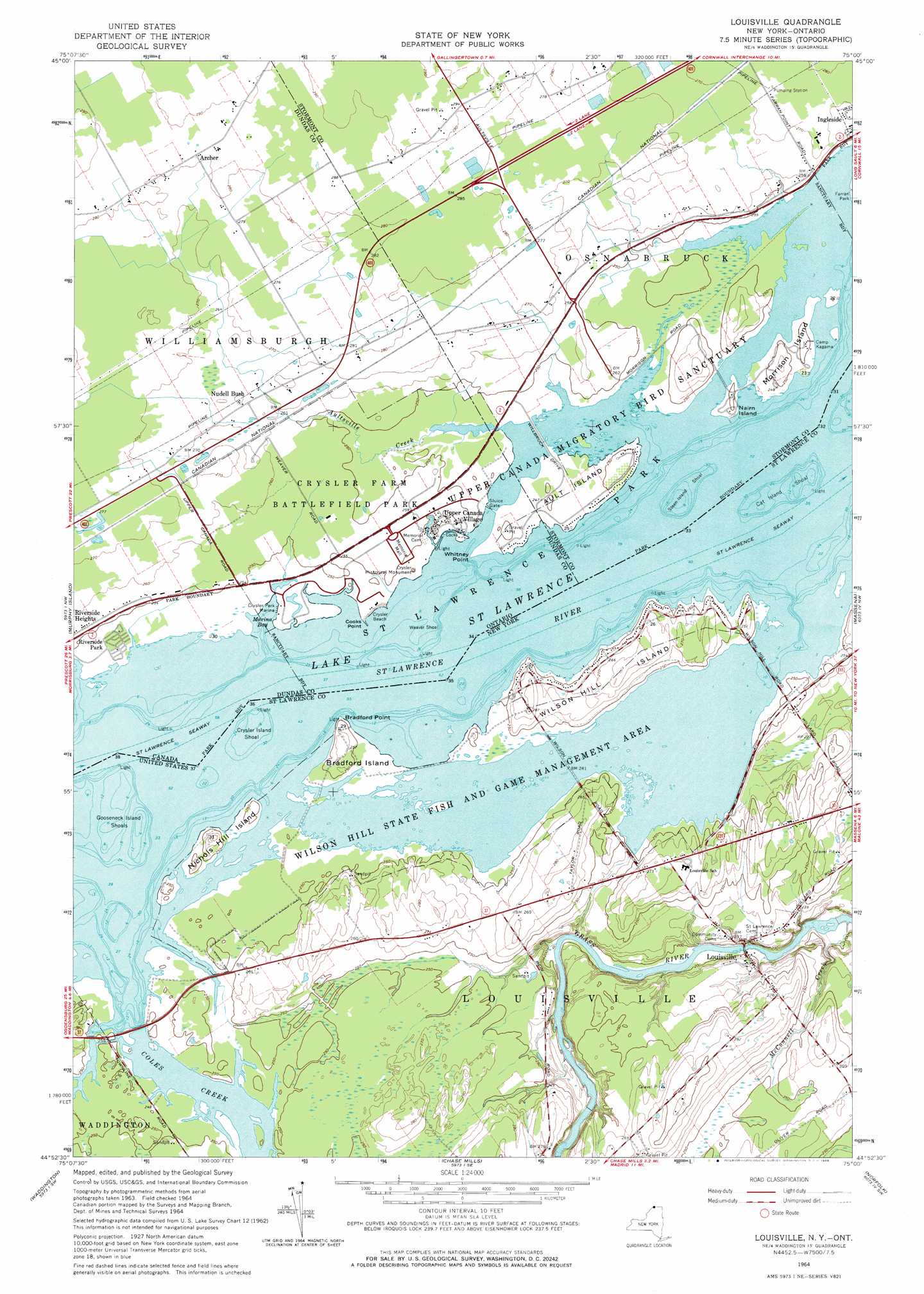
USGS Topo Quad 44075h1 - 1:24,000 scale
| Topo Map Name: | Louisville |
| USGS Topo Quad ID: | 44075h1 |
| Print Size: | ca. 21 1/4" wide x 27" high |
| Southeast Coordinates: | 44.875° N latitude / 75° W longitude |
| Map Center Coordinates: | 44.9375° N latitude / 75.0625° W longitude |
| U.S. State: | NY |
| Filename: | o44075h1.jpg |
| Download Map JPG Image: | Louisville topo map 1:24,000 scale |
| Map Type: | Topographic |
| Topo Series: | 7.5´ |
| Map Scale: | 1:24,000 |
| Source of Map Images: | United States Geological Survey (USGS) |
| Alternate Map Versions: |
Louisville NY 1946 Download PDF Buy paper map Louisville NY 1964, updated 1966 Download PDF Buy paper map Louisville NY 2011 Download PDF Buy paper map Louisville NY 2013 Download PDF Buy paper map Louisville NY 2016 Download PDF Buy paper map |
1:24,000 Topo Quads surrounding Louisville
Cornwall West |
||||
Morrisburg |
Louisville |
Massena |
Raquette River |
|
Sparrowhawk Point |
Waddington |
Chase Mills |
Norfolk |
Brasher Falls |
Lisbon |
Morley |
West Potsdam |
Potsdam |
Parishville |
> Back to 44075e1 at 1:100,000 scale
> Back to 44074a1 at 1:250,000 scale
> Back to U.S. Topo Maps home
Louisville topo map: Gazetteer
Louisville: Bars
Cat Island Shoal elevation 73m 239′Crysler Shoal elevation 73m 239′
Louisville: Capes
Bradford Point elevation 74m 242′Louisville: Islands
Bradford Island elevation 76m 249′Cat Island (historical) elevation 73m 239′
Gooseneck Island (historical) elevation 73m 239′
Nichols Hill Island elevation 76m 249′
Strawberry Island (historical) elevation 73m 239′
Treasure Island (historical) elevation 73m 239′
Wilson Hill Island elevation 84m 275′
Louisville: Parks
Wilson Hill State Fish and Game Managemen elevation 73m 239′Louisville: Populated Places
Louisville elevation 66m 216′Louisville Corner elevation 82m 269′
Louisville: Streams
Coles Creek elevation 73m 239′Louisville: Summits
Nichols Hill elevation 77m 252′Wilson Hill elevation 84m 275′
Louisville digital topo map on disk
Buy this Louisville topo map showing relief, roads, GPS coordinates and other geographical features, as a high-resolution digital map file on DVD:
New York, Vermont, Connecticut & Western Massachusetts
Buy digital topo maps: New York, Vermont, Connecticut & Western Massachusetts