Canby Se Topo Map Minnesota
To zoom in, hover over the map of Canby Se
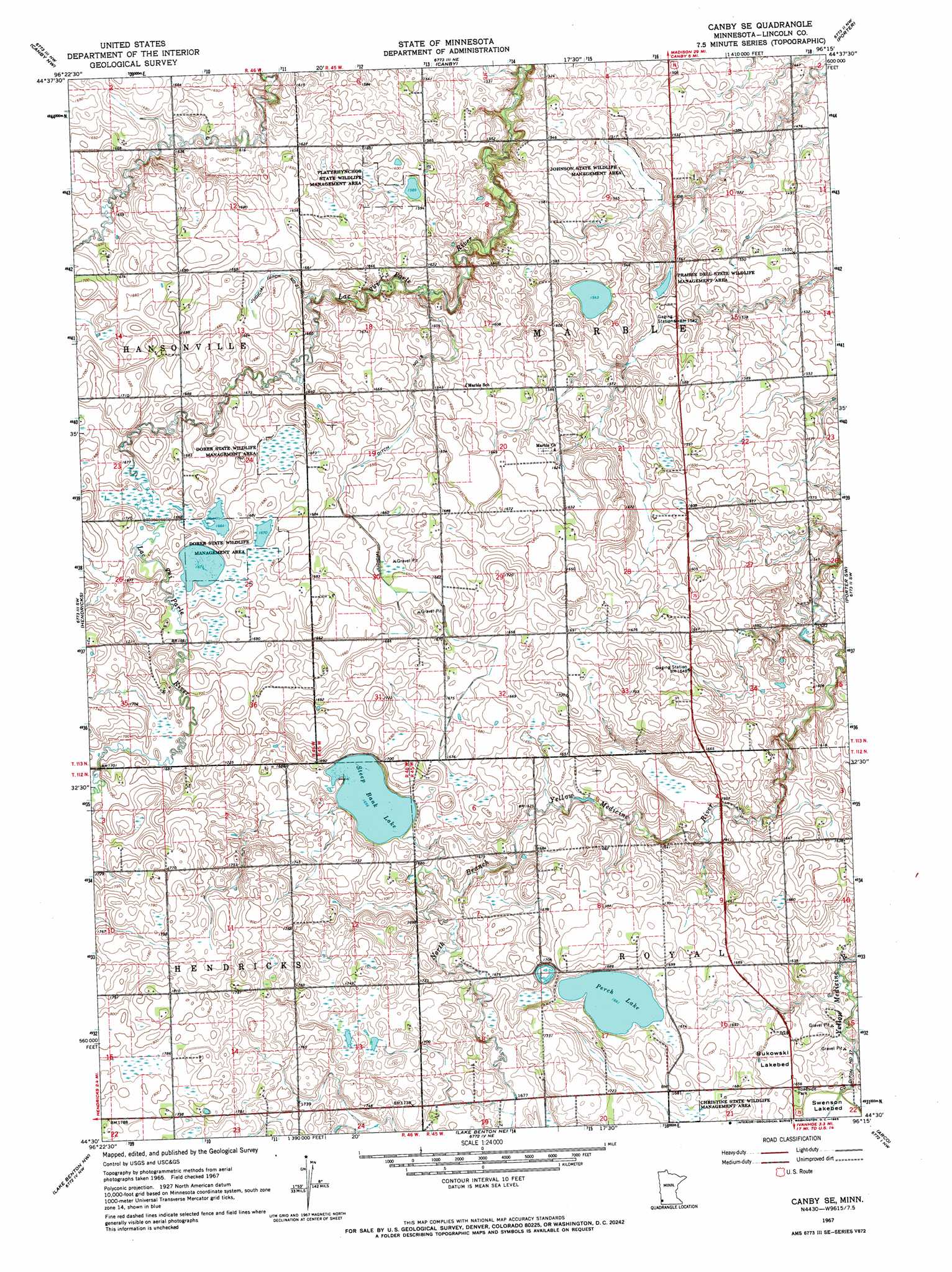
USGS Topo Quad 44096e3 - 1:24,000 scale
| Topo Map Name: | Canby Se |
| USGS Topo Quad ID: | 44096e3 |
| Print Size: | ca. 21 1/4" wide x 27" high |
| Southeast Coordinates: | 44.5° N latitude / 96.25° W longitude |
| Map Center Coordinates: | 44.5625° N latitude / 96.3125° W longitude |
| U.S. State: | MN |
| Filename: | o44096e3.jpg |
| Download Map JPG Image: | Canby Se topo map 1:24,000 scale |
| Map Type: | Topographic |
| Topo Series: | 7.5´ |
| Map Scale: | 1:24,000 |
| Source of Map Images: | United States Geological Survey (USGS) |
| Alternate Map Versions: |
Canby SE MN 1967, updated 1969 Download PDF Buy paper map Canby SE MN 2010 Download PDF Buy paper map Canby SE MN 2013 Download PDF Buy paper map Canby SE MN 2016 Download PDF Buy paper map |
1:24,000 Topo Quads surrounding Canby Se
Lake Francis |
Gary |
Gary Se |
Dawson Sw |
Providence |
Brandt |
Canby Nw |
Canby |
Porter |
Saint Leo |
Astoria |
Hendricks |
Canby Se |
Porter Sw |
Taunton |
White Ne |
Lake Benton Nw |
Lake Benton Ne |
Arco |
Gislason Lake |
White Se |
Lake Benton Sw |
Lake Benton |
Tyler |
Dead Coon Lake |
> Back to 44096e1 at 1:100,000 scale
> Back to 44096a1 at 1:250,000 scale
> Back to U.S. Topo Maps home
Canby Se topo map: Gazetteer
Canby Se: Canals
Judicial Ditch Number Ninteen elevation 500m 1640′Judicial Ditch Number Twentyone elevation 506m 1660′
Canby Se: Flats
Bukowski Lakebed elevation 503m 1650′Canby Se: Lakes
Perch Lake elevation 507m 1663′Steep Bank Lake elevation 505m 1656′
Canby Se: Parks
Christine State Wildlife Management Area elevation 512m 1679′Dorer State Wildlife Management Area elevation 511m 1676′
Dorer State Wildlife Management Area elevation 510m 1673′
Johnson State Wildlife Management Area elevation 459m 1505′
Platyrhynchos State Wildlife Management Area elevation 485m 1591′
Prairie Dell State Wildlife Management Area elevation 465m 1525′
Canby Se digital topo map on disk
Buy this Canby Se topo map showing relief, roads, GPS coordinates and other geographical features, as a high-resolution digital map file on DVD:
Eastern North Dakota & Eastern South Dakota
Buy digital topo maps: Eastern North Dakota & Eastern South Dakota