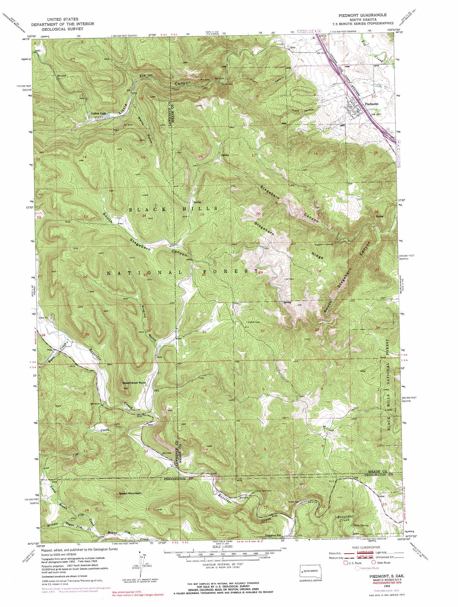
Piedmont Topo Map South Dakota
To zoom in, hover over the map of Piedmont
USGS Topo Quad 44103b4 - 1:24,000 scale
| Topo Map Name: | Piedmont |
| USGS Topo Quad ID: | 44103b4 |
| Print Size: | ca. 21 1/4" wide x 27" high |
| Southeast Coordinates: | 44.125° N latitude / 103.375° W longitude |
| Map Center Coordinates: | 44.1875° N latitude / 103.4375° W longitude |
| U.S. State: | SD |
| Filename: | o44103b4.jpg |
| Download Map JPG Image: | Piedmont topo map 1:24,000 scale |
| Map Type: | Topographic |
| Topo Series: | 7.5´ |
| Map Scale: | 1:24,000 |
| Source of Map Images: | United States Geological Survey (USGS) |
| Alternate Map Versions: |
Piedmont SD 1953, updated 1955 Download PDF Buy paper map Piedmont SD 1953, updated 1957 Download PDF Buy paper map Piedmont SD 1953, updated 1972 Download PDF Buy paper map Piedmont SD 1953, updated 1972 Download PDF Buy paper map Piedmont SD 1953, updated 1972 Download PDF Buy paper map Piedmont SD 1958, updated 1980 Download PDF Buy paper map Piedmont SD 2012 Download PDF Buy paper map Piedmont SD 2015 Download PDF Buy paper map |
| FStopo: | US Forest Service topo Piedmont is available: Download FStopo PDF Download FStopo TIF |
1:24,000 Topo Quads surrounding Piedmont
Deadwood North |
Sturgis |
Fort Meade |
Fort Meade Ne |
Rapid City 1 Nw |
Deadwood South |
Deadman Mountain |
Tilford |
Fort Meade Se |
Rapid City 1 Sw |
Minnesota Ridge |
Nemo |
Piedmont |
Blackhawk |
Rapid City Nw |
Rochford |
Silver City |
Pactola Dam |
Rapid City West |
Rapid City East |
Medicine Mountain |
Hill City |
Mount Rushmore |
Rockerville |
Hermosa Nw |
> Back to 44103a1 at 1:100,000 scale
> Back to 44102a1 at 1:250,000 scale
> Back to U.S. Topo Maps home
Piedmont topo map: Gazetteer
Piedmont: Gaps
Custer Gap elevation 1262m 4140′Red Gate elevation 1218m 3996′
White Gate elevation 1173m 3848′
Piedmont: Pillars
Steamboat Rock elevation 1540m 5052′Piedmont: Populated Places
Carwye (historical) elevation 1375m 4511′Goiens (historical) elevation 1273m 4176′
Piedmont elevation 1065m 3494′
Piedmont: Reservoirs
Datton Lake elevation 1339m 4393′Piedmont: Ridges
Stagebarn Ridge elevation 1397m 4583′Piedmont: Springs
Doty Spring elevation 1228m 4028′Piedmont: Streams
Estes Creek elevation 1378m 4520′Jim Creek elevation 1335m 4379′
Middle Bogus Jim Creek elevation 1393m 4570′
North Bogus Jim Creek elevation 1393m 4570′
Piedmont: Summits
Green Mountain elevation 1587m 5206′Piedmont: Valleys
Chimney Canyon elevation 1119m 3671′Erskine Gulch elevation 1353m 4438′
Little Elk Canyon elevation 1091m 3579′
Priest Canyon elevation 1095m 3592′
South Stagebarn Canyon elevation 1117m 3664′
Waite Gulch elevation 1317m 4320′
Piedmont digital topo map on disk
Buy this Piedmont topo map showing relief, roads, GPS coordinates and other geographical features, as a high-resolution digital map file on DVD:
Eastern Wyoming & Western South Dakota
Buy digital topo maps: Eastern Wyoming & Western South Dakota