Hill City Topo Map South Dakota
To zoom in, hover over the map of Hill City
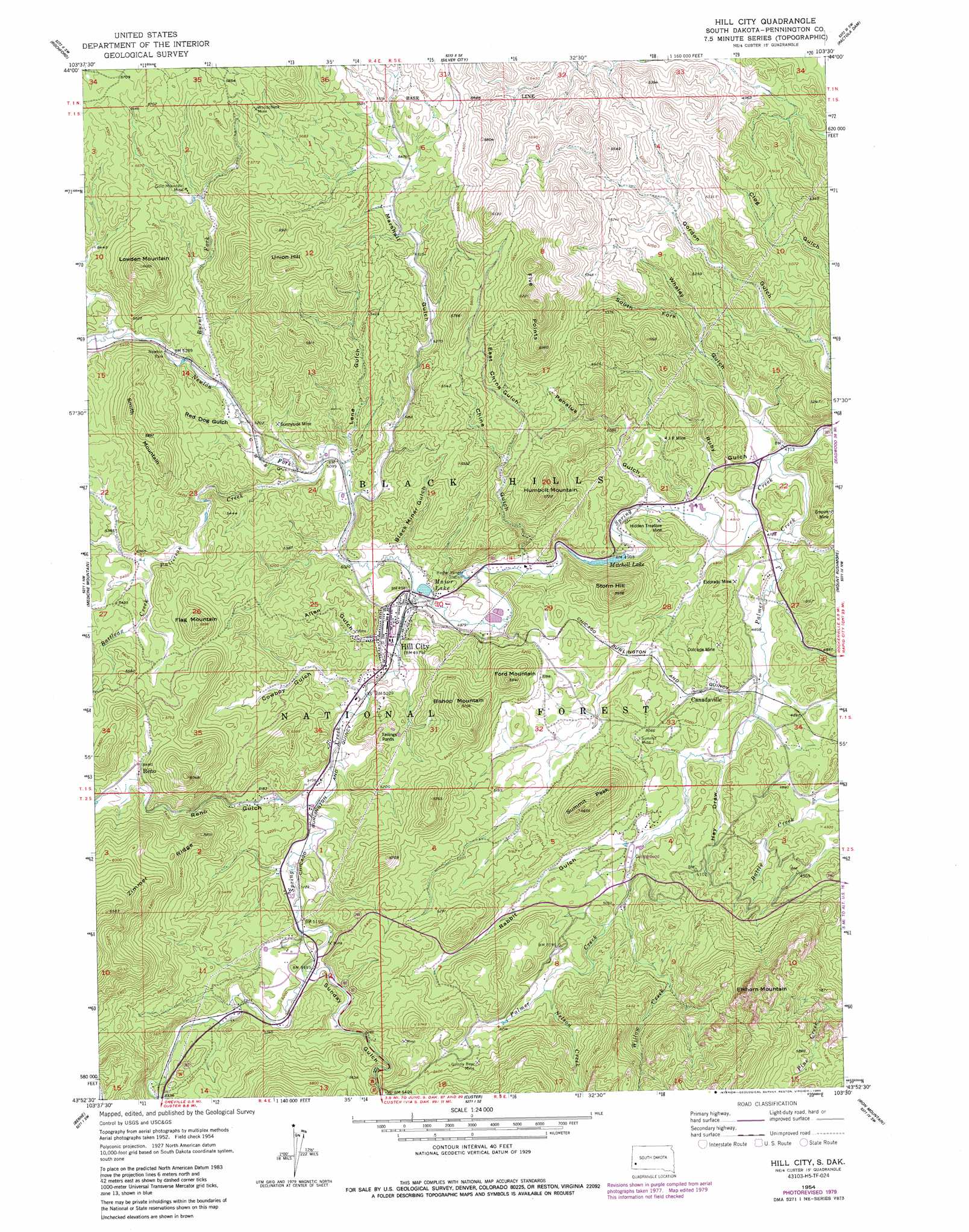
USGS Topo Quad 43103h5 - 1:24,000 scale
| Topo Map Name: | Hill City |
| USGS Topo Quad ID: | 43103h5 |
| Print Size: | ca. 21 1/4" wide x 27" high |
| Southeast Coordinates: | 43.875° N latitude / 103.5° W longitude |
| Map Center Coordinates: | 43.9375° N latitude / 103.5625° W longitude |
| U.S. State: | SD |
| Filename: | o43103h5.jpg |
| Download Map JPG Image: | Hill City topo map 1:24,000 scale |
| Map Type: | Topographic |
| Topo Series: | 7.5´ |
| Map Scale: | 1:24,000 |
| Source of Map Images: | United States Geological Survey (USGS) |
| Alternate Map Versions: |
Hill City SD 1954, updated 1955 Download PDF Buy paper map Hill City SD 1954, updated 1957 Download PDF Buy paper map Hill City SD 1954, updated 1974 Download PDF Buy paper map Hill City SD 1954, updated 1979 Download PDF Buy paper map Hill City SD 1954, updated 1986 Download PDF Buy paper map Hill City SD 1998, updated 2001 Download PDF Buy paper map Hill City SD 2012 Download PDF Buy paper map Hill City SD 2015 Download PDF Buy paper map |
| FStopo: | US Forest Service topo Hill City is available: Download FStopo PDF Download FStopo TIF |
1:24,000 Topo Quads surrounding Hill City
Nahant |
Minnesota Ridge |
Nemo |
Piedmont |
Blackhawk |
Deerfield |
Rochford |
Silver City |
Pactola Dam |
Rapid City West |
Ditch Creek |
Medicine Mountain |
Hill City |
Mount Rushmore |
Rockerville |
Signal Hill |
Berne |
Custer |
Iron Mountain |
Hayward |
Jewel Cave |
Fourmile |
Cicero Peak |
Mount Coolidge |
Butcher Hill |
> Back to 43103e1 at 1:100,000 scale
> Back to 43102a1 at 1:250,000 scale
> Back to U.S. Topo Maps home
Hill City topo map: Gazetteer
Hill City: Dams
Mitchell Lake Dam elevation 1525m 5003′Hill City: Flats
Newton Park elevation 1611m 5285′Hill City: Mines
Addie Lode Mine elevation 1503m 4931′Annie Number 1 Lode Mine elevation 1579m 5180′
Antler-Burlington Mine elevation 1614m 5295′
Black Crystal Mine elevation 1563m 5127′
Black Metal Mine elevation 1612m 5288′
Blackbird Mine elevation 1524m 5000′
Bluebird Claim Mine elevation 1718m 5636′
Buckeye and Lena Mine elevation 1809m 5935′
Campaign Mine elevation 1633m 5357′
Carnbray Mine elevation 1508m 4947′
Cassiterite Mine elevation 1556m 5104′
Century Mine elevation 1567m 5141′
Champion Mine elevation 1504m 4934′
Coats Dike Mine elevation 1596m 5236′
Cowboy Mine elevation 1597m 5239′
Crain Mine elevation 1754m 5754′
Custer Group Mine elevation 1504m 4934′
Dewey Mine elevation 1650m 5413′
Dolcode Mine elevation 1516m 4973′
Dyke Mine elevation 1597m 5239′
El Dorado Mine elevation 1498m 4914′
Eldorado Mine elevation 1496m 4908′
Elkhorn Mine elevation 1512m 4960′
Empire Mine elevation 1524m 5000′
Empire Mine elevation 1526m 5006′
Excelsior Mine elevation 1558m 5111′
February Mine elevation 1522m 4993′
Gertie Mine elevation 1548m 5078′
Gold Hill Mine elevation 1683m 5521′
Gold Mountain Mine elevation 1691m 5547′
Golden Summit Mine elevation 1536m 5039′
Good Luck Mine elevation 1479m 4852′
Greenback Mine elevation 1625m 5331′
Grizzly Bear Mine elevation 1646m 5400′
Hidden Treasure Mine elevation 1484m 4868′
High Lode Mine elevation 1673m 5488′
Ida Mine elevation 1506m 4940′
J R Extension Mine elevation 1509m 4950′
J R Mine elevation 1524m 5000′
Jolly Mine elevation 1545m 5068′
Martha Washington Mine elevation 1491m 4891′
McKinnon and Millers Claim Mine elevation 1680m 5511′
Mohawk Mine elevation 1560m 5118′
Monkey Lode Mine elevation 1722m 5649′
OK Lode Mine elevation 1748m 5734′
Olympia Mine elevation 1618m 5308′
Pettit and Pfanders Claim Mine elevation 1564m 5131′
Reinbold Claim Mine elevation 1622m 5321′
Summit Mine elevation 1534m 5032′
Sunnyside Mine elevation 1602m 5255′
Tim Plate Mine elevation 1716m 5629′
Tin Boom Mine elevation 1585m 5200′
Tin Center Mine elevation 1518m 4980′
Tin Chance Mine elevation 1572m 5157′
Vida May Mine elevation 1489m 4885′
White Swan Mine elevation 1551m 5088′
White Whale Mine elevation 1611m 5285′
Wolfram Lode elevation 1572m 5157′
Woodchuck Mine elevation 1780m 5839′
Hill City: Populated Places
Five Points elevation 1880m 6167′Gold Mountain Subdivision elevation 1603m 5259′
Hill City elevation 1519m 4983′
Kennedyville elevation 1491m 4891′
Reno elevation 1676m 5498′
Hill City: Reservoirs
Major Lake elevation 1513m 4963′Mitchell Lake elevation 1525m 5003′
Hill City: Ridges
The Pulpit elevation 1561m 5121′Zimmer Ridge elevation 1994m 6541′
Hill City: Streams
Battle Creek elevation 1627m 5337′Battleax Creek elevation 1625m 5331′
Burnt Fork elevation 1596m 5236′
Nelson Creek elevation 1566m 5137′
Newton Fork elevation 1513m 4963′
Palmer Creek elevation 1433m 4701′
Patterson Creek elevation 1559m 5114′
Willow Creek elevation 1524m 5000′
Hill City: Summits
Bishop Mountain elevation 1734m 5688′Campaign Hill elevation 1771m 5810′
Elkhorn Mountain elevation 1940m 6364′
Flag Mountain elevation 1788m 5866′
Ford Mountain elevation 1708m 5603′
Humbolt Mountain elevation 1730m 5675′
Lowden Mountain elevation 1839m 6033′
Smith Mountain elevation 1793m 5882′
Storm Hill elevation 1711m 5613′
Summit Peak elevation 1693m 5554′
Union Hill elevation 1863m 6112′
Hill City: Trails
Willow Creek Trail elevation 1544m 5065′Hill City: Valleys
Allen Gulch elevation 1525m 5003′Black Miner Gulch elevation 1522m 4993′
China Gulch elevation 1499m 4917′
Cowboy Gulch elevation 1536m 5039′
East China Gulch elevation 1586m 5203′
Hay Draw elevation 1487m 4878′
Lena Gulch elevation 1551m 5088′
Marshall Gulch elevation 1546m 5072′
Penalua Gulch elevation 1461m 4793′
Rabbit Gulch elevation 1513m 4963′
Red Dog Gulch elevation 1586m 5203′
Reno Gulch elevation 1549m 5082′
Ruby Gulch elevation 1444m 4737′
South Fork Whaley Gulch elevation 1490m 4888′
Sunday Gulch elevation 1579m 5180′
Whaley Gulch elevation 1436m 4711′
Hill City digital topo map on disk
Buy this Hill City topo map showing relief, roads, GPS coordinates and other geographical features, as a high-resolution digital map file on DVD:
Eastern Wyoming & Western South Dakota
Buy digital topo maps: Eastern Wyoming & Western South Dakota