Canyon Village Topo Map Wyoming
To zoom in, hover over the map of Canyon Village
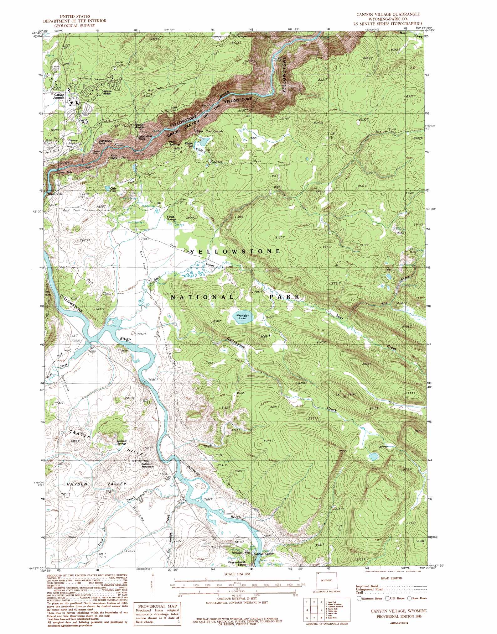
USGS Topo Quad 44110f4 - 1:24,000 scale
| Topo Map Name: | Canyon Village |
| USGS Topo Quad ID: | 44110f4 |
| Print Size: | ca. 21 1/4" wide x 27" high |
| Southeast Coordinates: | 44.625° N latitude / 110.375° W longitude |
| Map Center Coordinates: | 44.6875° N latitude / 110.4375° W longitude |
| U.S. State: | WY |
| Filename: | o44110f4.jpg |
| Download Map JPG Image: | Canyon Village topo map 1:24,000 scale |
| Map Type: | Topographic |
| Topo Series: | 7.5´ |
| Map Scale: | 1:24,000 |
| Source of Map Images: | United States Geological Survey (USGS) |
| Alternate Map Versions: |
Canyon Village WY 1986, updated 1986 Download PDF Buy paper map Canyon Village WY 2012 Download PDF Buy paper map Canyon Village WY 2015 Download PDF Buy paper map |
1:24,000 Topo Quads surrounding Canyon Village
Mammoth |
Blacktail Deer Creek |
Tower Junction |
Lamar Canyon |
Mount Hornaday |
Obsidian Cliff |
Cook Peak |
Mount Washburn |
Amethyst Mountain |
Opal Creek |
Norris Junction |
Crystal Falls |
Canyon Village |
White Lake |
Pelican Cone |
Mary Lake |
Beach Lake |
Lake |
Lake Butte |
Mount Chittenden |
Craig Pass |
West Thumb |
Dot Island |
Frank Island |
Sylvan Lake |
> Back to 44110e1 at 1:100,000 scale
> Back to 44110a1 at 1:250,000 scale
> Back to U.S. Topo Maps home
Canyon Village topo map: Gazetteer
Canyon Village: Capes
Artist Point elevation 2329m 7641′Grand View elevation 2392m 7847′
Lookout Point elevation 2386m 7828′
Canyon Village: Cliffs
Inspiration Point elevation 2374m 7788′Point Sublime elevation 2330m 7644′
Canyon Village: Falls
Lower Falls of the Yellowstone River elevation 2259m 7411′Silver Cord Cascade elevation 2396m 7860′
Upper Falls of the Yellowstone River elevation 2310m 7578′
Canyon Village: Lakes
Clear Lake elevation 2383m 7818′Ribbon Lake elevation 2384m 7821′
Wrangler Lake elevation 2394m 7854′
Canyon Village: Pillars
Red Rock elevation 2373m 7785′Canyon Village: Populated Places
Canyon Junction elevation 2412m 7913′Canyon Village elevation 2417m 7929′
Canyon Village: Springs
Dragons Mouth Spring elevation 2393m 7851′Forest Springs elevation 2360m 7742′
Mud Pots elevation 2383m 7818′
Sulphur Caldron elevation 2355m 7726′
Sulphur Spring elevation 2388m 7834′
Turbulent Pool elevation 2360m 7742′
Canyon Village: Streams
Alum Creek elevation 2342m 7683′Bog Creek elevation 2380m 7808′
Cascade Creek elevation 2288m 7506′
Cottongrass Creek elevation 2342m 7683′
Elk Antler Creek elevation 2344m 7690′
Sour Creek elevation 2342m 7683′
Surface Creek elevation 2089m 6853′
Trout Creek elevation 2345m 7693′
Canyon Village: Summits
Crater Hills elevation 2398m 7867′Sulphur Mountain elevation 2418m 7933′
Canyon Village: Trails
Glacial Boulder Trail elevation 2462m 8077′Ribbon Lake Trail elevation 2370m 7775′
Sour Creek Trail elevation 2351m 7713′
Canyon Village: Valleys
Hayden Valley elevation 2349m 7706′Canyon Village digital topo map on disk
Buy this Canyon Village topo map showing relief, roads, GPS coordinates and other geographical features, as a high-resolution digital map file on DVD: