Blacktail Deer Creek Topo Map Wyoming
To zoom in, hover over the map of Blacktail Deer Creek
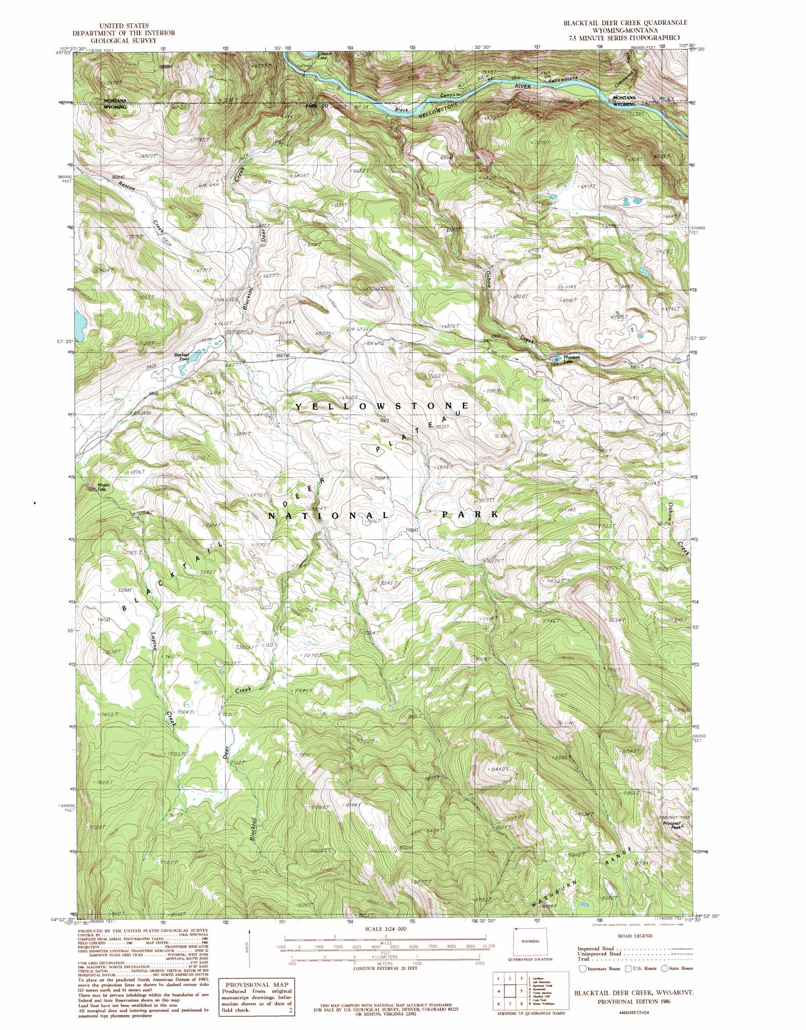
USGS Topo Quad 44110h5 - 1:24,000 scale
| Topo Map Name: | Blacktail Deer Creek |
| USGS Topo Quad ID: | 44110h5 |
| Print Size: | ca. 21 1/4" wide x 27" high |
| Southeast Coordinates: | 44.875° N latitude / 110.5° W longitude |
| Map Center Coordinates: | 44.9375° N latitude / 110.5625° W longitude |
| U.S. States: | WY, MT |
| Filename: | o44110h5.jpg |
| Download Map JPG Image: | Blacktail Deer Creek topo map 1:24,000 scale |
| Map Type: | Topographic |
| Topo Series: | 7.5´ |
| Map Scale: | 1:24,000 |
| Source of Map Images: | United States Geological Survey (USGS) |
| Alternate Map Versions: |
Blacktail Deer Creek WY 1986, updated 1986 Download PDF Buy paper map Blacktail Deer Creek WY 2011 Download PDF Buy paper map Blacktail Deer Creek WY 2012 Download PDF Buy paper map Blacktail Deer Creek WY 2015 Download PDF Buy paper map |
1:24,000 Topo Quads surrounding Blacktail Deer Creek
Dome Mountain |
Monitor Peak |
Mineral Mountain |
Mount Wallace |
Iron Mountain |
Electric Peak |
Gardiner |
Ash Mountain |
Specimen Creek |
Hummingbird Peak |
Quadrant Mountain |
Mammoth |
Blacktail Deer Creek |
Tower Junction |
Lamar Canyon |
Mount Holmes |
Obsidian Cliff |
Cook Peak |
Mount Washburn |
Amethyst Mountain |
Madison Junction |
Norris Junction |
Crystal Falls |
Canyon Village |
White Lake |
> Back to 44110e1 at 1:100,000 scale
> Back to 44110a1 at 1:250,000 scale
> Back to U.S. Topo Maps home
Blacktail Deer Creek topo map: Gazetteer
Blacktail Deer Creek: Areas
Blacktail Deer Plateau elevation 2168m 7112′Blacktail Deer Creek: Bridges
Blacktail Bridge elevation 1688m 5538′Blacktail Deer Creek: Falls
Wraith Falls elevation 2060m 6758′Blacktail Deer Creek: Lakes
Blacktail Pond elevation 2012m 6601′Phantom Lake elevation 2064m 6771′
Blacktail Deer Creek: Streams
Blacktail Deer Creek elevation 1697m 5567′Blacktail Deer Creek elevation 1687m 5534′
Cottonwood Creek elevation 1702m 5583′
Oxbow Creek elevation 1695m 5561′
Rescue Creek elevation 1964m 6443′
Blacktail Deer Creek: Summits
Prospect Peak elevation 2904m 9527′Blacktail Deer Creek: Trails
Lower Blacktail Trail elevation 1959m 6427′Lower Blacktail Trail elevation 1817m 5961′
Rescue Creek Trail elevation 2041m 6696′
Blacktail Deer Creek digital topo map on disk
Buy this Blacktail Deer Creek topo map showing relief, roads, GPS coordinates and other geographical features, as a high-resolution digital map file on DVD: