Norris Junction Topo Map Wyoming
To zoom in, hover over the map of Norris Junction
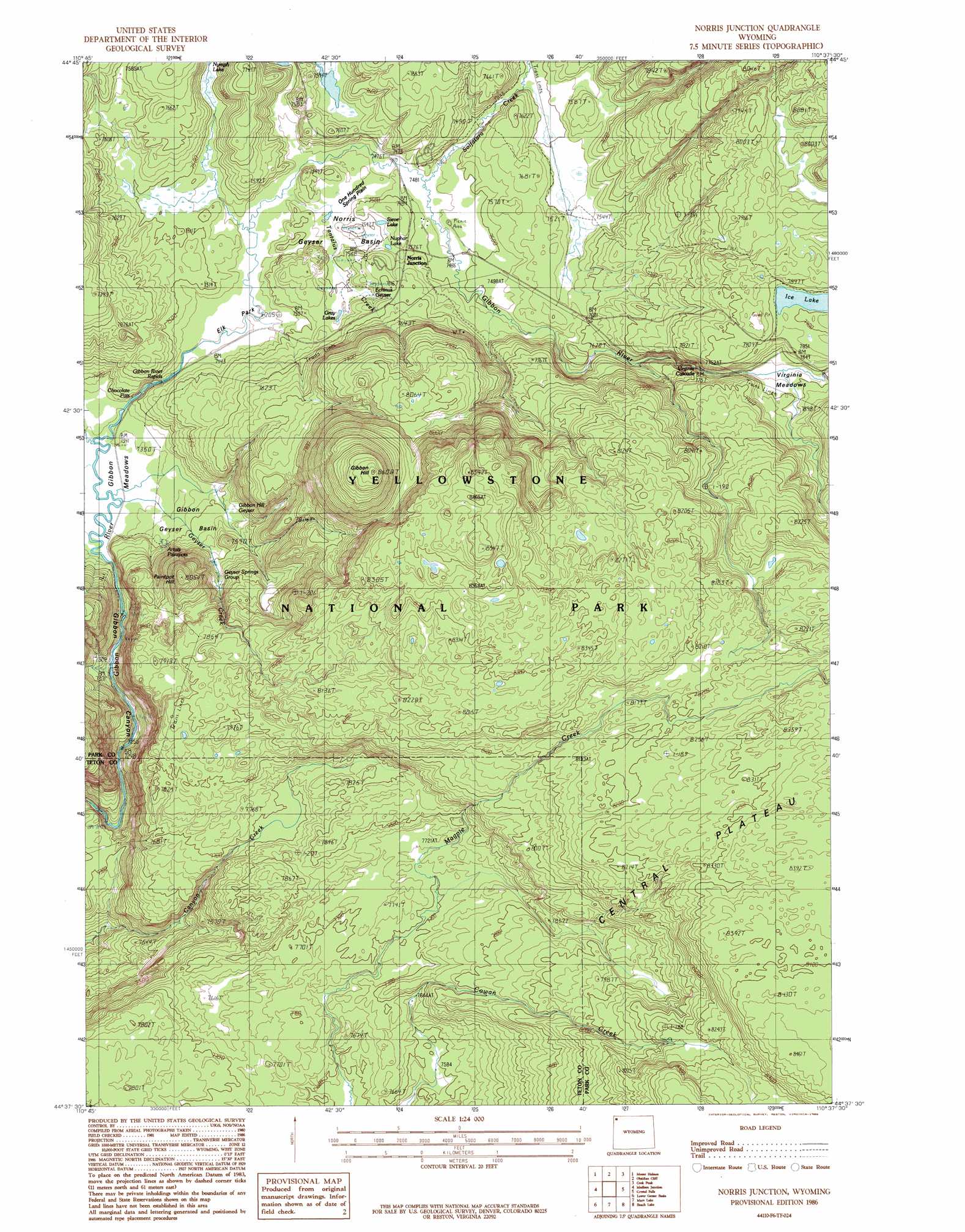
USGS Topo Quad 44110f6 - 1:24,000 scale
| Topo Map Name: | Norris Junction |
| USGS Topo Quad ID: | 44110f6 |
| Print Size: | ca. 21 1/4" wide x 27" high |
| Southeast Coordinates: | 44.625° N latitude / 110.625° W longitude |
| Map Center Coordinates: | 44.6875° N latitude / 110.6875° W longitude |
| U.S. State: | WY |
| Filename: | o44110f6.jpg |
| Download Map JPG Image: | Norris Junction topo map 1:24,000 scale |
| Map Type: | Topographic |
| Topo Series: | 7.5´ |
| Map Scale: | 1:24,000 |
| Source of Map Images: | United States Geological Survey (USGS) |
| Alternate Map Versions: |
Norris Junction WY 1986, updated 1986 Download PDF Buy paper map Norris Junction WY 2012 Download PDF Buy paper map Norris Junction WY 2015 Download PDF Buy paper map |
1:24,000 Topo Quads surrounding Norris Junction
Joseph Peak |
Quadrant Mountain |
Mammoth |
Blacktail Deer Creek |
Tower Junction |
Three Rivers Peak |
Mount Holmes |
Obsidian Cliff |
Cook Peak |
Mount Washburn |
Mount Jackson |
Madison Junction |
Norris Junction |
Crystal Falls |
Canyon Village |
Buffalo Meadows |
Lower Geyser Basin |
Mary Lake |
Beach Lake |
Lake |
Summit Lake |
Old Faithful |
Craig Pass |
West Thumb |
Dot Island |
> Back to 44110e1 at 1:100,000 scale
> Back to 44110a1 at 1:250,000 scale
> Back to U.S. Topo Maps home
Norris Junction topo map: Gazetteer
Norris Junction: Basins
Gibbon Geyser Basin elevation 2235m 7332′Norris Geyser Basin elevation 2281m 7483′
Norris Junction: Craters
Monarch Geyser elevation 2402m 7880′Norris Junction: Falls
Virginia Cascade elevation 2382m 7814′Norris Junction: Flats
Elk Park elevation 2269m 7444′One Hundred Spring Plain elevation 2279m 7477′
Virginia Meadows elevation 2372m 7782′
Norris Junction: Lakes
Gray Lakes elevation 2294m 7526′Ice Lake elevation 2406m 7893′
Nuphar Lake elevation 2292m 7519′
Sieve Lake elevation 2286m 7500′
Norris Junction: Pillars
Duck Rock elevation 2245m 7365′Norris Junction: Rapids
Gibbon River Rapids elevation 2262m 7421′Norris Junction: Springs
Artists Paintpots elevation 2252m 7388′Bathtub Spring elevation 2575m 8448′
Beryl Spring elevation 2250m 7381′
Black Growler elevation 2402m 7880′
Chocolate Pots elevation 2240m 7349′
Cistern Spring elevation 2289m 7509′
Congress Pool elevation 2294m 7526′
Constant Geyser elevation 2280m 7480′
Corporal Geyser elevation 2575m 8448′
Crater Hills Geyser elevation 2336m 7664′
Echinus Geyser elevation 2309m 7575′
Emerald Spring elevation 2575m 8448′
Fearless Geyser elevation 2575m 8448′
Fenner Drill Hole elevation 2316m 7598′
Geyser Springs Group elevation 2291m 7516′
Gibbon Hill Geyser elevation 2267m 7437′
Horseshoe Spring elevation 2280m 7480′
Hurricane Vent elevation 2290m 7513′
Medusa Spring elevation 2289m 7509′
New Crater Geyser elevation 2402m 7880′
Palpitator Spring elevation 2402m 7880′
Pearl Geyser elevation 2290m 7513′
Perpetual Spouter elevation 2288m 7506′
Phillips Caldron elevation 2287m 7503′
Porkchop Geyser elevation 2513m 8244′
Realgar Spring elevation 2277m 7470′
Realgar Springs elevation 2317m 7601′
Scalloped Spring elevation 2293m 7522′
Steamboat Geyser elevation 2316m 7598′
Valentine Geyser elevation 2293m 7522′
Vixen Geyser elevation 2290m 7513′
Whirligig Geyser elevation 2290m 7513′
Norris Junction: Streams
Geyser Creek elevation 2237m 7339′Realgar Creek elevation 2291m 7516′
Solfatara Creek elevation 2280m 7480′
Tantalus Creek elevation 2272m 7454′
Norris Junction: Summits
Gibbon Hill elevation 2613m 8572′Paintpot Hill elevation 2454m 8051′
Norris Junction: Trails
Howard Eaton Trail elevation 2287m 7503′Ice Lakes Trail elevation 2414m 7919′
Norris Junction digital topo map on disk
Buy this Norris Junction topo map showing relief, roads, GPS coordinates and other geographical features, as a high-resolution digital map file on DVD: