Borah Peak Topo Map Idaho
To zoom in, hover over the map of Borah Peak
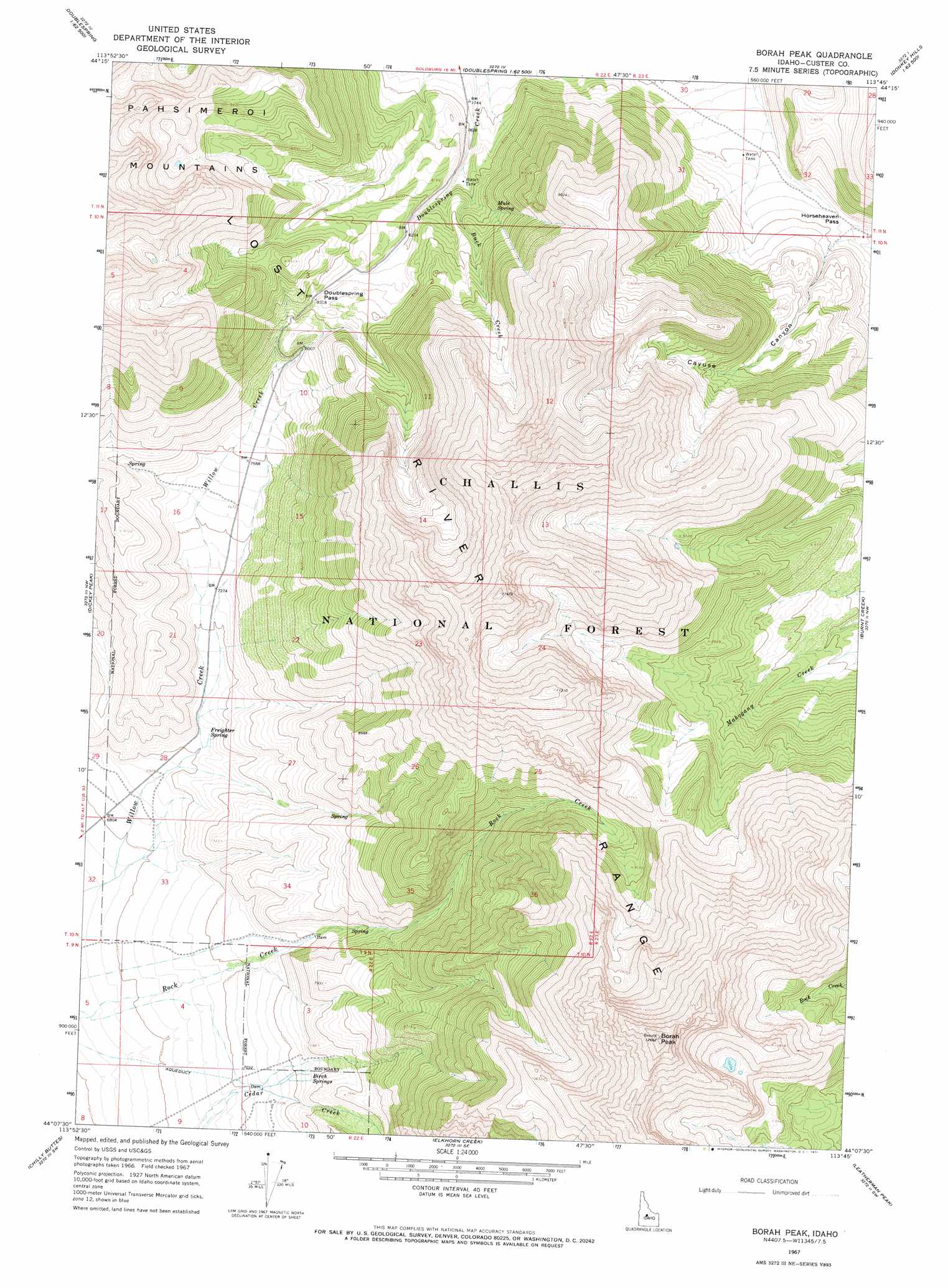
USGS Topo Quad 44113b7 - 1:24,000 scale
| Topo Map Name: | Borah Peak |
| USGS Topo Quad ID: | 44113b7 |
| Print Size: | ca. 21 1/4" wide x 27" high |
| Southeast Coordinates: | 44.125° N latitude / 113.75° W longitude |
| Map Center Coordinates: | 44.1875° N latitude / 113.8125° W longitude |
| U.S. State: | ID |
| Filename: | o44113b7.jpg |
| Download Map JPG Image: | Borah Peak topo map 1:24,000 scale |
| Map Type: | Topographic |
| Topo Series: | 7.5´ |
| Map Scale: | 1:24,000 |
| Source of Map Images: | United States Geological Survey (USGS) |
| Alternate Map Versions: |
Borah Peak ID 1967, updated 1971 Download PDF Buy paper map Borah Peak ID 1967, updated 1971 Download PDF Buy paper map Borah Peak ID 2011 Download PDF Buy paper map Borah Peak ID 2013 Download PDF Buy paper map |
| FStopo: | US Forest Service topo Borah Peak is available: Download FStopo PDF Download FStopo TIF |
1:24,000 Topo Quads surrounding Borah Peak
Little Antelope Flat |
Meadow Peak |
Mahogany Hill |
Donkey Hills Nw |
Big Creek Peak |
Antelope Flat |
Grouse Creek Mountain |
Doublespring |
Spring Hill |
Donkey Creek |
Horse Basin |
Dickey Peak |
Borah Peak |
Burnt Creek |
Short Creek |
Jerry Peak |
Chilly Buttes |
Elkhorn Creek |
Leatherman Peak |
Massacre Mountain |
Harry Canyon |
Porphyry Peak |
Lehman Butte |
Mackay Reservoir |
Mackay |
> Back to 44113a1 at 1:100,000 scale
> Back to 44112a1 at 1:250,000 scale
> Back to U.S. Topo Maps home
Borah Peak topo map: Gazetteer
Borah Peak: Gaps
Doublespring Pass elevation 2537m 8323′Horseheaven Pass elevation 2424m 7952′
Borah Peak: Springs
Birch Springs elevation 2230m 7316′Freighter Spring elevation 2146m 7040′
Mule Spring elevation 2515m 8251′
Borah Peak: Streams
Buck Creek elevation 2392m 7847′Borah Peak: Summits
Borah Peak elevation 3813m 12509′Borah Peak: Valleys
Cayuse Canyon elevation 2429m 7969′Borah Peak digital topo map on disk
Buy this Borah Peak topo map showing relief, roads, GPS coordinates and other geographical features, as a high-resolution digital map file on DVD: