Fingerboard Saddle Topo Map Oregon
To zoom in, hover over the map of Fingerboard Saddle
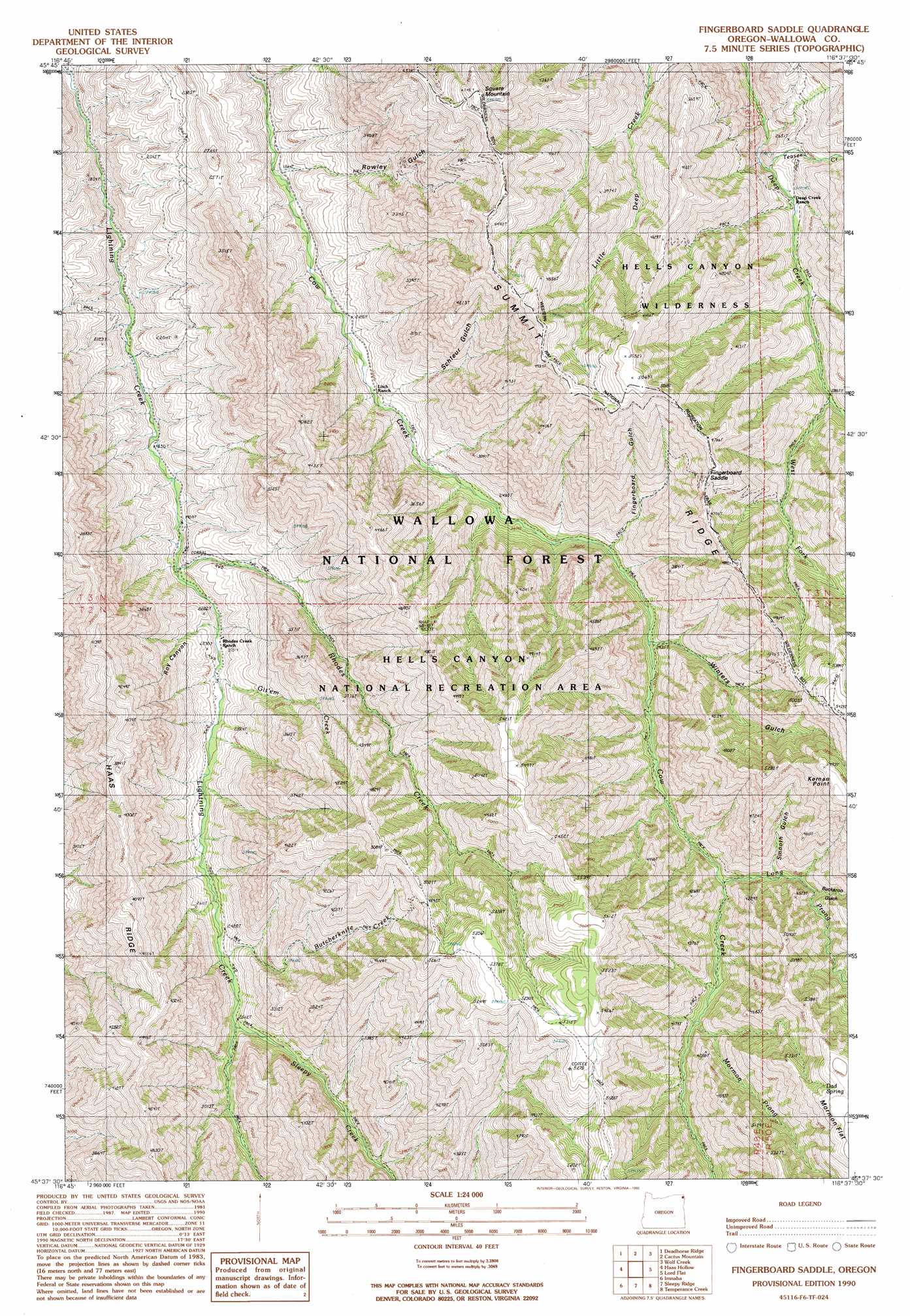
USGS Topo Quad 45116f6 - 1:24,000 scale
| Topo Map Name: | Fingerboard Saddle |
| USGS Topo Quad ID: | 45116f6 |
| Print Size: | ca. 21 1/4" wide x 27" high |
| Southeast Coordinates: | 45.625° N latitude / 116.625° W longitude |
| Map Center Coordinates: | 45.6875° N latitude / 116.6875° W longitude |
| U.S. State: | OR |
| Filename: | o45116f6.jpg |
| Download Map JPG Image: | Fingerboard Saddle topo map 1:24,000 scale |
| Map Type: | Topographic |
| Topo Series: | 7.5´ |
| Map Scale: | 1:24,000 |
| Source of Map Images: | United States Geological Survey (USGS) |
| Alternate Map Versions: |
Fingerboard Saddle OR 1990, updated 1990 Download PDF Buy paper map Fingerboard Saddle OR 2011 Download PDF Buy paper map Fingerboard Saddle OR 2014 Download PDF Buy paper map |
| FStopo: | US Forest Service topo Fingerboard Saddle is available: Download FStopo PDF Download FStopo TIF |
1:24,000 Topo Quads surrounding Fingerboard Saddle
Jim Creek Butte |
Wapshilla Creek |
Rattlesnake Ridge |
Boles |
Moughmer Point |
Poison Point |
Deadhorse Ridge |
Cactus Mountain |
Wolf Creek |
Joseph |
Zumwalt |
Haas Hollow |
Fingerboard Saddle |
Lord Flat |
Grave Point |
Findley Buttes |
Imnaha |
Sleepy Ridge |
Temperance Creek |
Kirkwood Creek |
Clear Lake Ridge |
Sheep Creek Divide |
Hat Point |
Old Time Mountain |
Kessler Creek |
> Back to 45116e1 at 1:100,000 scale
> Back to 45116a1 at 1:250,000 scale
> Back to U.S. Topo Maps home
Fingerboard Saddle topo map: Gazetteer
Fingerboard Saddle: Gaps
Fingerboard Saddle elevation 1319m 4327′Fingerboard Saddle: Springs
Dad Spring elevation 1676m 5498′Winters Spring elevation 1659m 5442′
Fingerboard Saddle: Streams
Butcherknife Creek elevation 743m 2437′Git'em Creek elevation 651m 2135′
Long Prong elevation 1177m 3861′
Mormon Prong elevation 1126m 3694′
Rhodes Creek elevation 596m 1955′
Sleepy Creek elevation 768m 2519′
Teaser Creek elevation 789m 2588′
West Fork Deep Creek elevation 944m 3097′
Fingerboard Saddle: Summits
Kernan Point elevation 1666m 5465′Square Mountain elevation 1437m 4714′
Fingerboard Saddle: Valleys
Buckaroo Gulch elevation 1075m 3526′Fingerboard Gulch elevation 827m 2713′
Rowley Gulch elevation 563m 1847′
Roy Canyon elevation 642m 2106′
Schleur Gulch elevation 679m 2227′
Smooth Gulch elevation 1086m 3562′
Winters Gulch elevation 879m 2883′
Fingerboard Saddle digital topo map on disk
Buy this Fingerboard Saddle topo map showing relief, roads, GPS coordinates and other geographical features, as a high-resolution digital map file on DVD: