Hagerman Lake Topo Map Michigan
To zoom in, hover over the map of Hagerman Lake
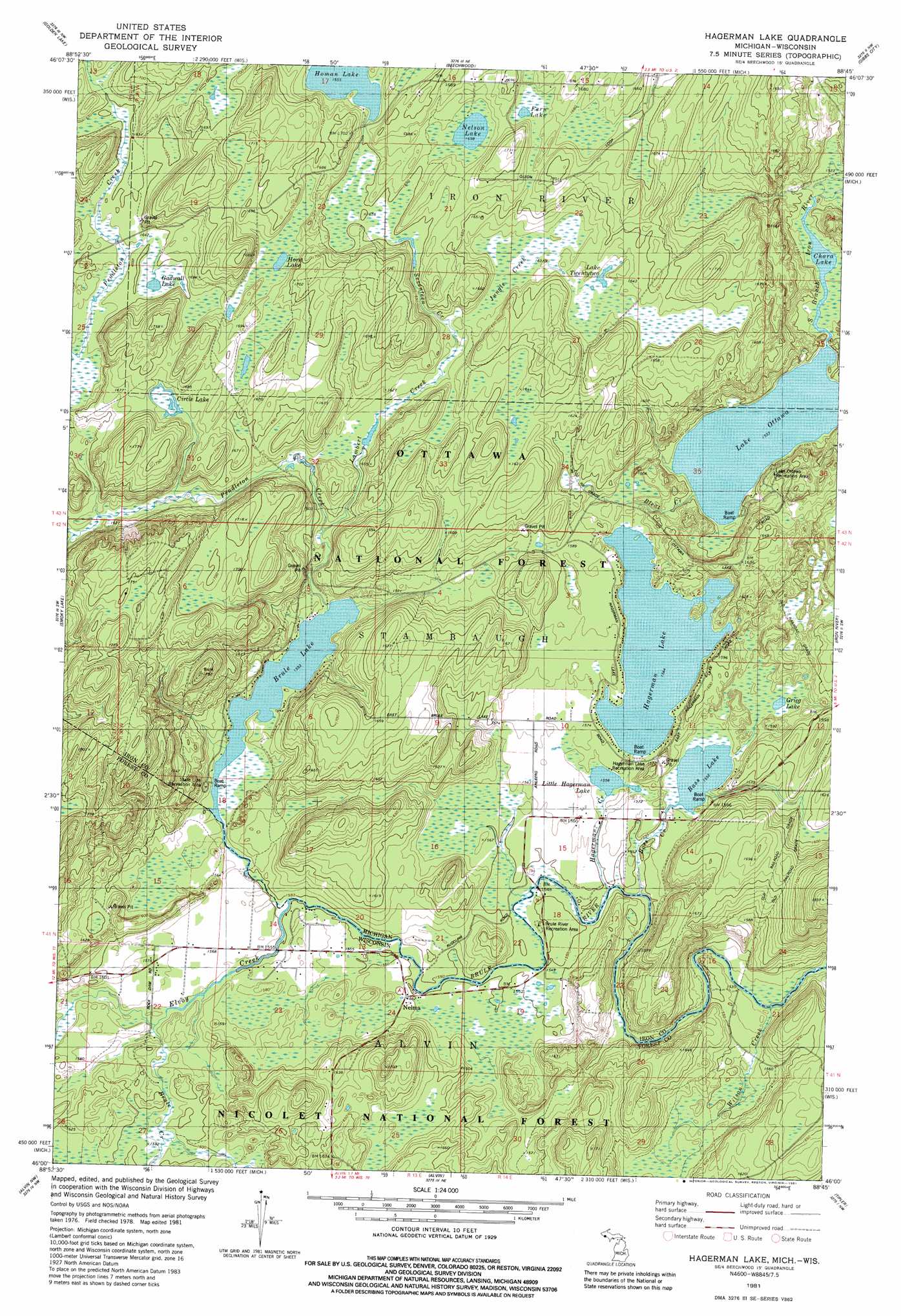
USGS Topo Quad 46088a7 - 1:24,000 scale
| Topo Map Name: | Hagerman Lake |
| USGS Topo Quad ID: | 46088a7 |
| Print Size: | ca. 21 1/4" wide x 27" high |
| Southeast Coordinates: | 46° N latitude / 88.75° W longitude |
| Map Center Coordinates: | 46.0625° N latitude / 88.8125° W longitude |
| U.S. States: | MI, WI |
| Filename: | o46088a7.jpg |
| Download Map JPG Image: | Hagerman Lake topo map 1:24,000 scale |
| Map Type: | Topographic |
| Topo Series: | 7.5´ |
| Map Scale: | 1:24,000 |
| Source of Map Images: | United States Geological Survey (USGS) |
| Alternate Map Versions: |
Hagerman Lake MI 1981, updated 1981 Download PDF Buy paper map Hagerman Lake MI 1999, updated 2004 Download PDF Buy paper map Hagerman Lake MI 2011 Download PDF Buy paper map Hagerman Lake MI 2014 Download PDF Buy paper map Hagerman Lake MI 2016 Download PDF Buy paper map |
| FStopo: | US Forest Service topo Hagerman Lake is available: Download FStopo PDF Download FStopo TIF |
1:24,000 Topo Quads surrounding Hagerman Lake
Fuller |
Lake Mitigwaki |
Winslow Lake |
Perch Lake |
Porter Lake |
Imp Lake |
Golden Lake |
Beechwood |
Gibbs City |
Sunset Lake |
Phelps |
Smoky Lake |
Hagerman Lake |
Iron River |
Gaastra |
Anvil Lake |
Alvin Nw |
Alvin |
Tipler |
Long Lake Ne |
Julia Lake |
Alvin Sw |
Alvin Se |
Long Lake |
Long Lake Se |
> Back to 46088a1 at 1:100,000 scale
> Back to 46088a1 at 1:250,000 scale
> Back to U.S. Topo Maps home
Hagerman Lake topo map: Gazetteer
Hagerman Lake: Lakes
Bass Lake elevation 473m 1551′Brule Lake elevation 473m 1551′
Chara Lake elevation 467m 1532′
Circle Lake elevation 507m 1663′
Fern Lake elevation 508m 1666′
Gadwall Lake elevation 502m 1646′
Greig Lake elevation 474m 1555′
Hagerman Lake elevation 477m 1564′
Homan Lake elevation 504m 1653′
Horn Lake elevation 507m 1663′
Lake Ottawa elevation 467m 1532′
Lake Twentytwo elevation 495m 1624′
Little Hagerman Lake elevation 474m 1555′
Nelson Lake elevation 505m 1656′
Hagerman Lake: Populated Places
Nelma elevation 475m 1558′Hagerman Lake: Streams
Bass Creek elevation 470m 1541′Bleat Creek elevation 467m 1532′
Brule Creek elevation 475m 1558′
Elvoy Creek elevation 472m 1548′
Hagerman Creek elevation 468m 1535′
Jungle Creek elevation 491m 1610′
Lambert Creek elevation 481m 1578′
Pendleton Creek elevation 473m 1551′
Seventeen Creek elevation 490m 1607′
Wilson Creek elevation 465m 1525′
Hagerman Lake digital topo map on disk
Buy this Hagerman Lake topo map showing relief, roads, GPS coordinates and other geographical features, as a high-resolution digital map file on DVD: