Alberta Topo Map Michigan
To zoom in, hover over the map of Alberta
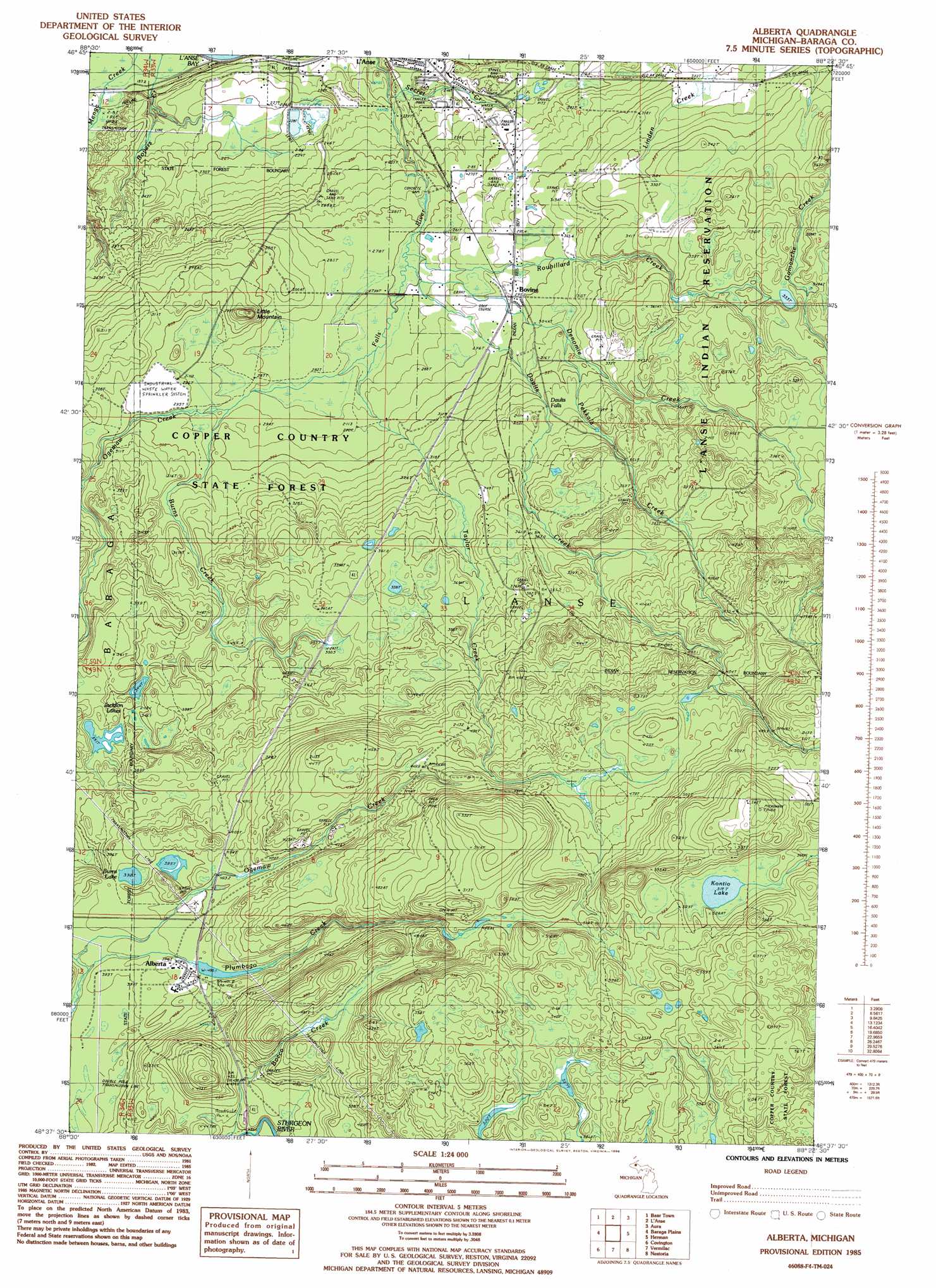
USGS Topo Quad 46088f4 - 1:24,000 scale
| Topo Map Name: | Alberta |
| USGS Topo Quad ID: | 46088f4 |
| Print Size: | ca. 21 1/4" wide x 27" high |
| Southeast Coordinates: | 46.625° N latitude / 88.375° W longitude |
| Map Center Coordinates: | 46.6875° N latitude / 88.4375° W longitude |
| U.S. State: | MI |
| Filename: | o46088f4.jpg |
| Download Map JPG Image: | Alberta topo map 1:24,000 scale |
| Map Type: | Topographic |
| Topo Series: | 7.5´ |
| Map Scale: | 1:24,000 |
| Source of Map Images: | United States Geological Survey (USGS) |
| Alternate Map Versions: |
Alberta MI 1985, updated 1986 Download PDF Buy paper map Alberta MI 2011 Download PDF Buy paper map Alberta MI 2014 Download PDF Buy paper map Alberta MI 2016 Download PDF Buy paper map |
1:24,000 Topo Quads surrounding Alberta
Pine Lake |
Otter Lake |
Portage Entry |
Keweenaw Bay Ne |
Skanee North |
Pelkie |
Bear Town |
L'Anse |
Aura |
Skanee South |
Prickett Lake |
Baraga Plains |
Alberta |
Herman |
Mount Curwood |
Sidnaw |
Covington |
Vermilac |
Nestoria |
Three Lakes |
Marten Lake |
Tunis |
Drummond Lake |
Ned Lake |
Nelson Lake |
> Back to 46088e1 at 1:100,000 scale
> Back to 46088a1 at 1:250,000 scale
> Back to U.S. Topo Maps home
Alberta topo map: Gazetteer
Alberta: Falls
Daults Falls elevation 333m 1092′Middle Falls River Falls elevation 224m 734′
Plumbago Falls elevation 472m 1548′
Power Dam Falls elevation 266m 872′
Power House Falls elevation 257m 843′
Alberta: Lakes
Burns Lake elevation 391m 1282′Jackson Lakes elevation 342m 1122′
Kontio Lake elevation 516m 1692′
Alberta: Parks
L'Anse-Lac Vieux Desert Trail Historical Marker elevation 183m 600′Alberta: Populated Places
Alberta elevation 401m 1315′Bovine elevation 296m 971′
L'Anse Mobile Home Court elevation 267m 875′
Alberta: Streams
Burns Creek elevation 291m 954′Daults Creek elevation 501m 1643′
Denomie Creek elevation 274m 898′
Menge Creek elevation 187m 613′
Pekkala Creek elevation 315m 1033′
Roubillard Creek elevation 274m 898′
Taylor Creek elevation 279m 915′
Alberta: Summits
Little Mountain elevation 336m 1102′Alberta digital topo map on disk
Buy this Alberta topo map showing relief, roads, GPS coordinates and other geographical features, as a high-resolution digital map file on DVD: