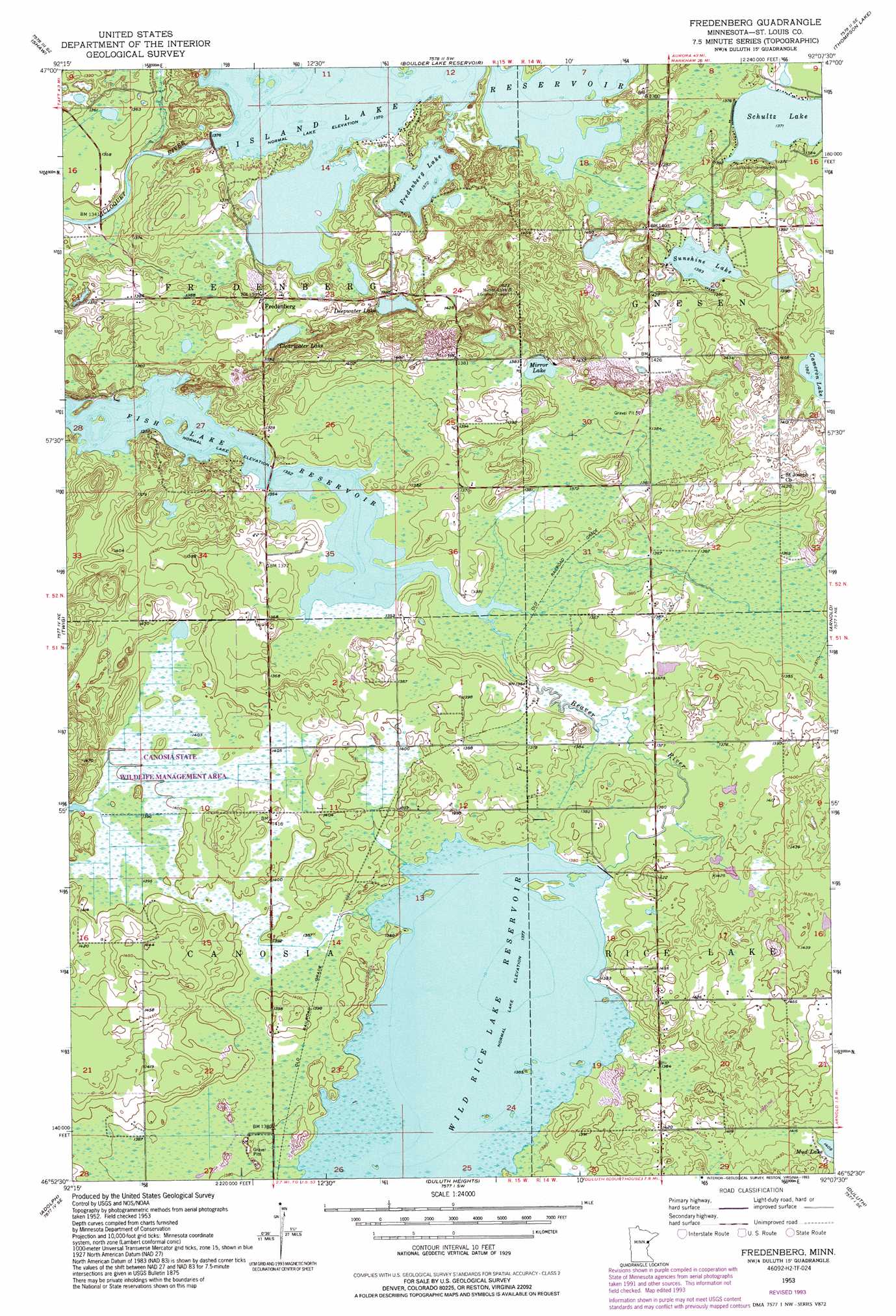
Fredenberg Topo Map Minnesota
To zoom in, hover over the map of Fredenberg
USGS Topo Quad 46092h2 - 1:24,000 scale
| Topo Map Name: | Fredenberg |
| USGS Topo Quad ID: | 46092h2 |
| Print Size: | ca. 21 1/4" wide x 27" high |
| Southeast Coordinates: | 46.875° N latitude / 92.125° W longitude |
| Map Center Coordinates: | 46.9375° N latitude / 92.1875° W longitude |
| U.S. State: | MN |
| Filename: | o46092h2.jpg |
| Download Map JPG Image: | Fredenberg topo map 1:24,000 scale |
| Map Type: | Topographic |
| Topo Series: | 7.5´ |
| Map Scale: | 1:24,000 |
| Source of Map Images: | United States Geological Survey (USGS) |
| Alternate Map Versions: |
Fredenberg MN 1953, updated 1955 Download PDF Buy paper map Fredenberg MN 1953, updated 1962 Download PDF Buy paper map Fredenberg MN 1953, updated 1970 Download PDF Buy paper map Fredenberg MN 1953, updated 1993 Download PDF Buy paper map Fredenberg MN 2010 Download PDF Buy paper map Fredenberg MN 2013 Download PDF Buy paper map Fredenberg MN 2016 Download PDF Buy paper map |
1:24,000 Topo Quads surrounding Fredenberg
Cotton |
Whiteface |
Comstock Lake |
Boulder Lake Reservoir Ne |
Pequaywan Lake |
Canyon |
Shaw |
Boulder Lake Reservoir |
Thompson Lake |
Barrs Lake |
Independence |
Twig |
Fredenberg |
Arnold |
French River |
Saginaw |
Adolph |
Duluth Heights |
Duluth |
Lakewood |
Cloquet |
Esko |
West Duluth |
Superior |
Parkland |
> Back to 46092e1 at 1:100,000 scale
> Back to 46092a1 at 1:250,000 scale
> Back to U.S. Topo Maps home
Fredenberg topo map: Gazetteer
Fredenberg: Airports
Wild Rice Lake Seaplane Base elevation 421m 1381′Fredenberg: Dams
Canosia Wildlife Management Area Dam elevation 426m 1397′Canosia Wildlife Management Area Number 6 Dam elevation 434m 1423′
Island Lake Dam elevation 418m 1371′
Rice Lake Dam elevation 420m 1377′
Fredenberg: Lakes
Clearwater Lake elevation 420m 1377′Deepwater Lake elevation 420m 1377′
Fredenberg Lake elevation 418m 1371′
Mirror Lake elevation 423m 1387′
Schultz Lake elevation 418m 1371′
Sunshine Lake elevation 422m 1384′
Fredenberg: Parks
Canosia State Wildlife Management Area elevation 428m 1404′Fredenberg: Populated Places
Fredenberg elevation 421m 1381′Fredenberg: Post Offices
Fredenburg Post Office (historical) elevation 420m 1377′Poland Post Office (historical) elevation 423m 1387′
Fredenberg: Reservoirs
Island Lake Reservoir elevation 416m 1364′Island Lake Reservoir elevation 418m 1371′
Rice Lake Reservoir elevation 420m 1377′
Wild Rice Lake Reservoir elevation 420m 1377′
Fredenberg digital topo map on disk
Buy this Fredenberg topo map showing relief, roads, GPS coordinates and other geographical features, as a high-resolution digital map file on DVD: