Lewiston Orchards North Topo Map Idaho
To zoom in, hover over the map of Lewiston Orchards North
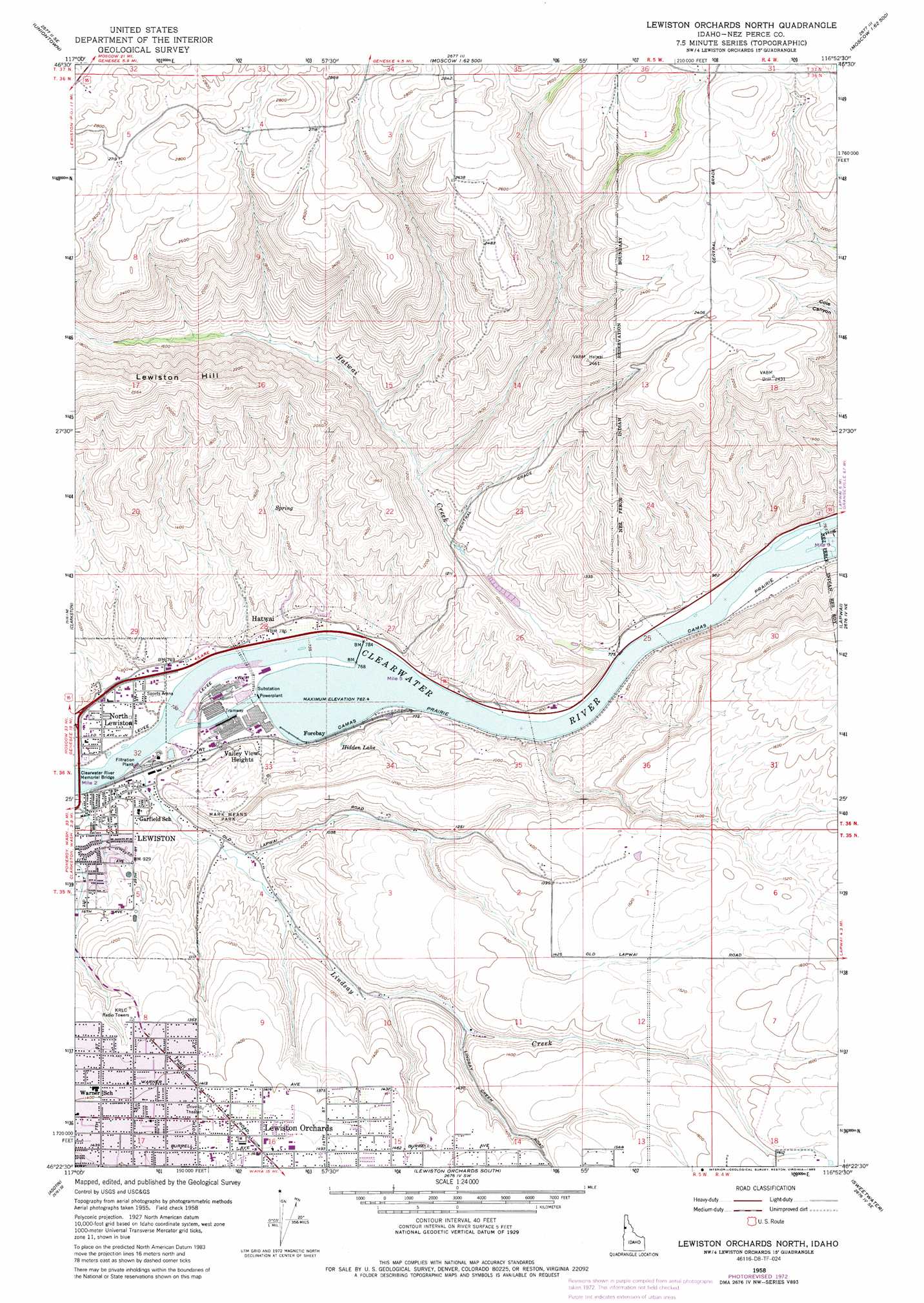
USGS Topo Quad 46116d8 - 1:24,000 scale
| Topo Map Name: | Lewiston Orchards North |
| USGS Topo Quad ID: | 46116d8 |
| Print Size: | ca. 21 1/4" wide x 27" high |
| Southeast Coordinates: | 46.375° N latitude / 116.875° W longitude |
| Map Center Coordinates: | 46.4375° N latitude / 116.9375° W longitude |
| U.S. State: | ID |
| Filename: | o46116d8.jpg |
| Download Map JPG Image: | Lewiston Orchards North topo map 1:24,000 scale |
| Map Type: | Topographic |
| Topo Series: | 7.5´ |
| Map Scale: | 1:24,000 |
| Source of Map Images: | United States Geological Survey (USGS) |
| Alternate Map Versions: |
Lewiston Orchards North ID 1958, updated 1960 Download PDF Buy paper map Lewiston Orchards North ID 1958, updated 1973 Download PDF Buy paper map Lewiston Orchards North ID 2010 Download PDF Buy paper map Lewiston Orchards North ID 2013 Download PDF Buy paper map |
1:24,000 Topo Quads surrounding Lewiston Orchards North
Pullman |
Moscow West |
Moscow East |
Troy |
Little Bear Ridge |
Colton |
Uniontown |
Genesee |
Green Knob |
Juliaetta |
Silcott Island |
Clarkston |
Lewiston Orchards North |
Lapwai |
Culdesac North |
Rockpile Creek |
Asotin |
Lewiston Orchards South |
Sweetwater |
Culdesac South |
Anatone |
Weissenfels Ridge |
Captain John Rapids |
Waha |
Winchester West |
> Back to 46116a1 at 1:100,000 scale
> Back to 46116a1 at 1:250,000 scale
> Back to U.S. Topo Maps home
Lewiston Orchards North topo map: Gazetteer
Lewiston Orchards North: Lakes
Hidden Lake elevation 257m 843′Lewiston Orchards North: Parks
Mark Means Park elevation 291m 954′Lewiston Orchards North: Populated Places
Forebay elevation 243m 797′Gurney elevation 241m 790′
Hatwai elevation 247m 810′
Lewiston Orchards elevation 439m 1440′
Valley View Heights elevation 243m 797′
Lewiston Orchards North: Streams
Hatwai Creek elevation 239m 784′Lindsay Creek elevation 230m 754′
McGuire Creek elevation 316m 1036′
Lewiston Orchards North: Summits
Lewiston Hill elevation 784m 2572′Lewiston Orchards North digital topo map on disk
Buy this Lewiston Orchards North topo map showing relief, roads, GPS coordinates and other geographical features, as a high-resolution digital map file on DVD: