Potlatch Topo Map Idaho
To zoom in, hover over the map of Potlatch
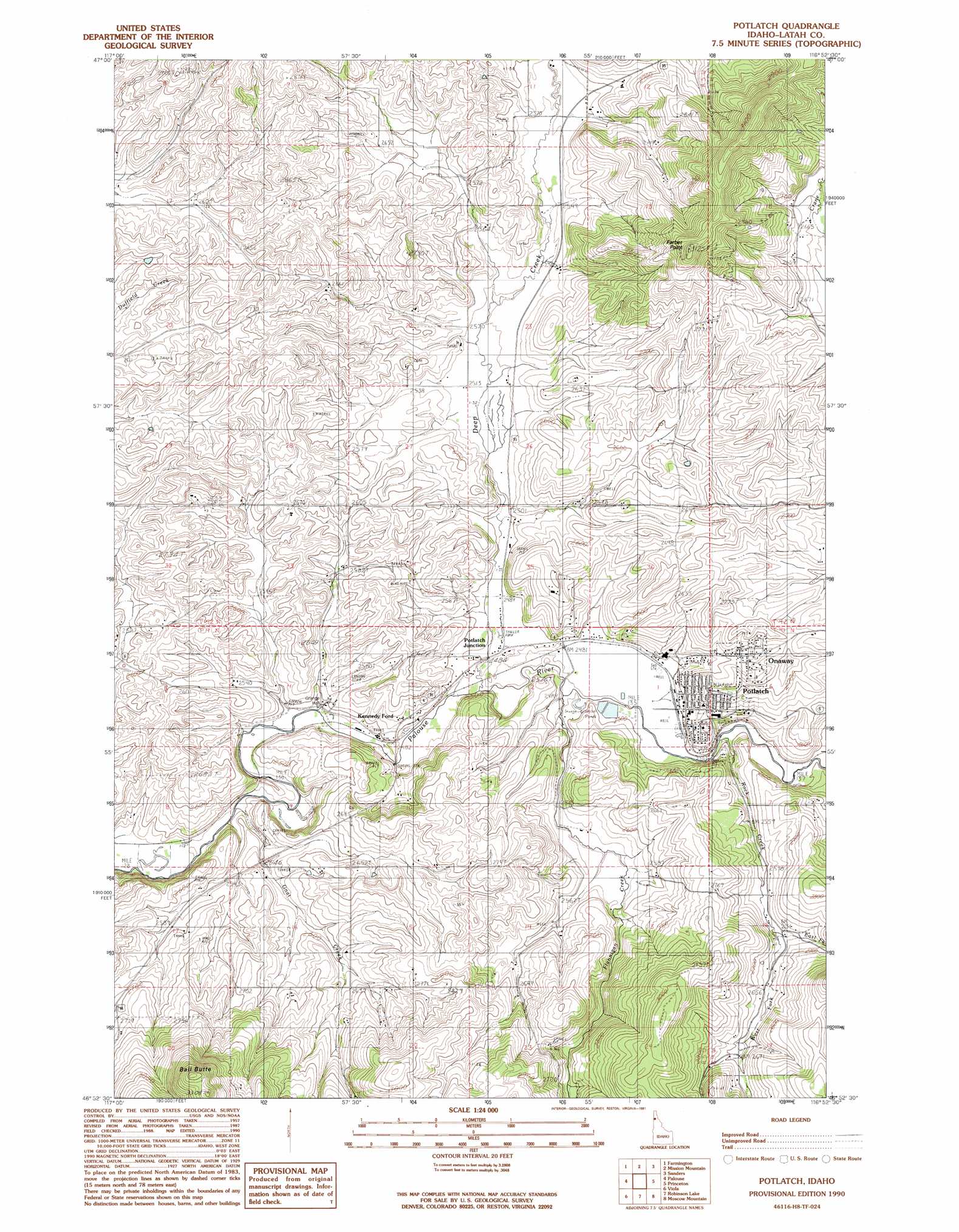
USGS Topo Quad 46116h8 - 1:24,000 scale
| Topo Map Name: | Potlatch |
| USGS Topo Quad ID: | 46116h8 |
| Print Size: | ca. 21 1/4" wide x 27" high |
| Southeast Coordinates: | 46.875° N latitude / 116.875° W longitude |
| Map Center Coordinates: | 46.9375° N latitude / 116.9375° W longitude |
| U.S. State: | ID |
| Filename: | o46116h8.jpg |
| Download Map JPG Image: | Potlatch topo map 1:24,000 scale |
| Map Type: | Topographic |
| Topo Series: | 7.5´ |
| Map Scale: | 1:24,000 |
| Source of Map Images: | United States Geological Survey (USGS) |
| Alternate Map Versions: |
Potlatch ID 1990, updated 1991 Download PDF Buy paper map Potlatch ID 1994, updated 1997 Download PDF Buy paper map Potlatch ID 1994, updated 1997 Download PDF Buy paper map Potlatch ID 2011 Download PDF Buy paper map Potlatch ID 2013 Download PDF Buy paper map |
| FStopo: | US Forest Service topo Potlatch is available: Download FStopo PDF Download FStopo TIF |
1:24,000 Topo Quads surrounding Potlatch
Oakesdale |
Tekoa |
Tensed |
Benewah |
Alder Creek Flats |
Garfield |
Farmington |
Mission Mountain |
Sanders |
West Dennis |
Elberton |
Palouse |
Potlatch |
Princeton |
Harvard |
Albion |
Viola |
Robinson Lake |
Moscow Mountain |
Stanford |
Pullman |
Moscow West |
Moscow East |
Troy |
Little Bear Ridge |
> Back to 46116e1 at 1:100,000 scale
> Back to 46116a1 at 1:250,000 scale
> Back to U.S. Topo Maps home
Potlatch topo map: Gazetteer
Potlatch: Airports
Anderson-Plummer Airport elevation 773m 2536′Potlatch: Populated Places
Freeze elevation 768m 2519′Onaway elevation 799m 2621′
Potlatch elevation 776m 2545′
Potlatch Junction elevation 758m 2486′
Potlatch: Streams
Deep Creek elevation 755m 2477′East Fork Rock Creek elevation 823m 2700′
Flannigan Creek elevation 757m 2483′
Gnat Creek elevation 751m 2463′
Rock Creek elevation 763m 2503′
West Fork Rock Creek elevation 818m 2683′
Potlatch: Summits
Ball Butte elevation 1015m 3330′Farber Point elevation 927m 3041′
Potlatch digital topo map on disk
Buy this Potlatch topo map showing relief, roads, GPS coordinates and other geographical features, as a high-resolution digital map file on DVD: