Syre Topo Map Minnesota
To zoom in, hover over the map of Syre
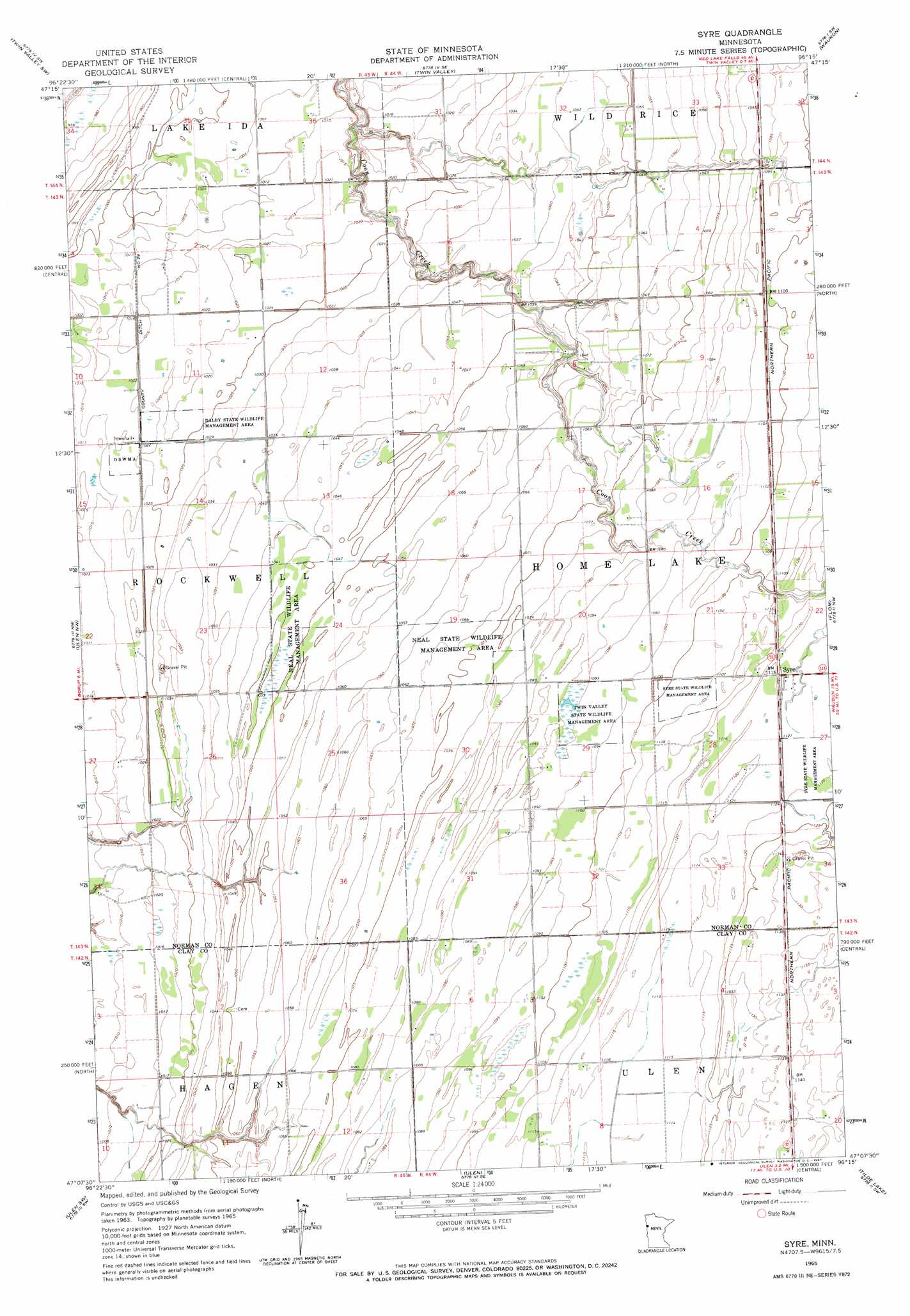
USGS Topo Quad 47096b3 - 1:24,000 scale
| Topo Map Name: | Syre |
| USGS Topo Quad ID: | 47096b3 |
| Print Size: | ca. 21 1/4" wide x 27" high |
| Southeast Coordinates: | 47.125° N latitude / 96.25° W longitude |
| Map Center Coordinates: | 47.1875° N latitude / 96.3125° W longitude |
| U.S. State: | MN |
| Filename: | o47096b3.jpg |
| Download Map JPG Image: | Syre topo map 1:24,000 scale |
| Map Type: | Topographic |
| Topo Series: | 7.5´ |
| Map Scale: | 1:24,000 |
| Source of Map Images: | United States Geological Survey (USGS) |
| Alternate Map Versions: |
Syre MN 1965, updated 1967 Download PDF Buy paper map Syre MN 2010 Download PDF Buy paper map Syre MN 2013 Download PDF Buy paper map Syre MN 2016 Download PDF Buy paper map |
1:24,000 Topo Quads surrounding Syre
Lockhart |
Twin Valley Nw |
Flaming |
Ranum |
Faith Ne |
Ada |
Twin Valley Sw |
Twin Valley |
Waukon |
Faith |
Borup |
Ulen Nw |
Syre |
Flom |
Flom Ne |
Felton |
Ulen Sw |
Ulen |
Tilde Lake |
Flom Se |
Glyndon North |
Hawley Nw |
Hawley |
Dale |
Lake Park |
> Back to 47096a1 at 1:100,000 scale
> Back to 47096a1 at 1:250,000 scale
> Back to U.S. Topo Maps home
Syre topo map: Gazetteer
Syre: Canals
County Ditch Number Twentynine elevation 310m 1017′Syre: Dams
Rockwell Dam elevation 310m 1017′Syre: Parks
Dalby State Wildlife Management Area elevation 312m 1023′Neal State Wildlife Management Area elevation 325m 1066′
Syre State Wildlife Management Area elevation 341m 1118′
Twin Valley State Wildlife Management Are elevation 333m 1092′
Syre: Populated Places
Syre elevation 342m 1122′Syre: Post Offices
Syre Post Office (historical) elevation 340m 1115′Syre digital topo map on disk
Buy this Syre topo map showing relief, roads, GPS coordinates and other geographical features, as a high-resolution digital map file on DVD:
Eastern North Dakota & Eastern South Dakota
Buy digital topo maps: Eastern North Dakota & Eastern South Dakota