Whately Topo Map Montana
To zoom in, hover over the map of Whately
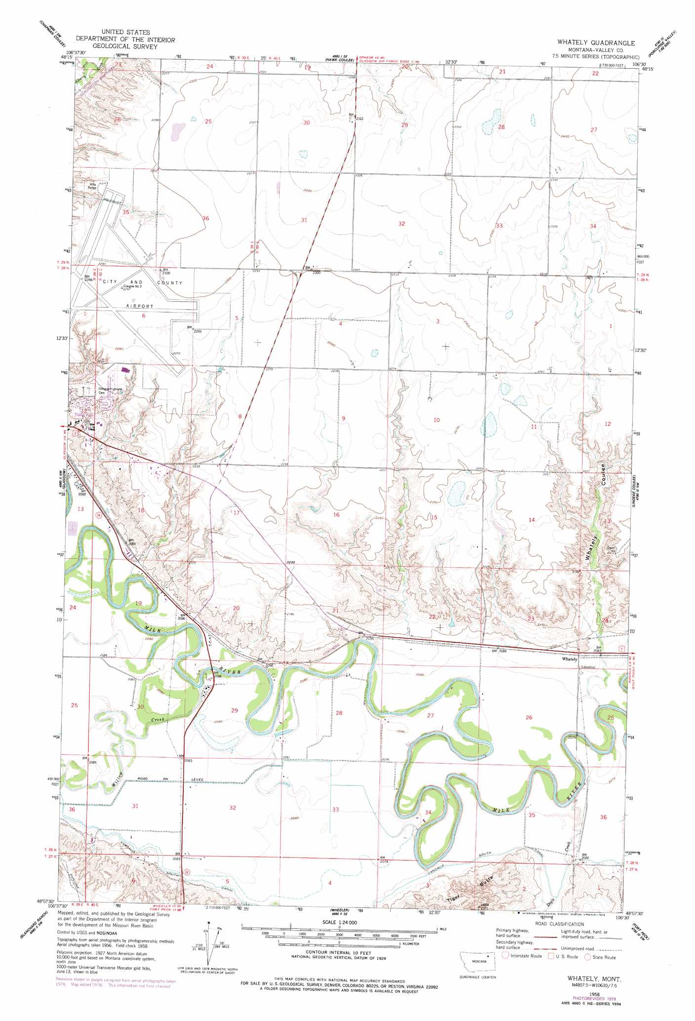
USGS Topo Quad 48106b5 - 1:24,000 scale
| Topo Map Name: | Whately |
| USGS Topo Quad ID: | 48106b5 |
| Print Size: | ca. 21 1/4" wide x 27" high |
| Southeast Coordinates: | 48.125° N latitude / 106.5° W longitude |
| Map Center Coordinates: | 48.1875° N latitude / 106.5625° W longitude |
| U.S. State: | MT |
| Filename: | o48106b5.jpg |
| Download Map JPG Image: | Whately topo map 1:24,000 scale |
| Map Type: | Topographic |
| Topo Series: | 7.5´ |
| Map Scale: | 1:24,000 |
| Source of Map Images: | United States Geological Survey (USGS) |
| Alternate Map Versions: |
Whately MT 1958, updated 1960 Download PDF Buy paper map Whately MT 1958, updated 1960 Download PDF Buy paper map Whately MT 1958, updated 1978 Download PDF Buy paper map Whately MT 2011 Download PDF Buy paper map Whately MT 2014 Download PDF Buy paper map |
1:24,000 Topo Quads surrounding Whately
Tampico Ne |
Cornwell Reservoir |
Chapman Coulee Ne |
Lookout |
Bullhead Reservoir |
Tampico |
Chapman Coulee |
Hawk Coulee |
Uhlan Coulee |
Sargent Creek |
Engstrom Ranch |
Glasgow |
Whately |
Lindeke Coulee |
Nashua |
Miller Coulee East |
Blanchard Ranch |
Wheeler |
Fort Peck |
Milk River Hills |
Bomber Coulee |
Lewis Reservoir |
Skunk Coulee |
York Island |
Bobcat Creek |
> Back to 48106a1 at 1:100,000 scale
> Back to 48106a1 at 1:250,000 scale
> Back to U.S. Topo Maps home
Whately topo map: Gazetteer
Whately: Airports
Glasgow International Airport elevation 699m 2293′Whately: Bridges
Milk River Bridge elevation 624m 2047′Whately: Canals
Vandalia South Canal elevation 638m 2093′Whately: Dams
Hanson Dam elevation 702m 2303′Whately: Parks
Centennial Park elevation 665m 2181′Scottie Field elevation 691m 2267′
Smith Clinic Park elevation 652m 2139′
Sullivan Park elevation 637m 2089′
Whately: Populated Places
Whately elevation 638m 2093′Whately: Post Offices
Whately Post Office (historical) elevation 638m 2093′Whately: Streams
Dogie Creek elevation 625m 2050′Willow Creek elevation 627m 2057′
Whately: Summits
Tiger Butte elevation 718m 2355′Whately: Valleys
Goudge Coulee elevation 640m 2099′Whately Coulee elevation 638m 2093′
Whately: Wells
27N40E06CDCD01 Well elevation 639m 2096′28N40E15DDAB01 Well elevation 684m 2244′
28N40E22CABC01 Well elevation 643m 2109′
28N40E31CCBA01 Well elevation 639m 2096′
28N40E31CCBD01 Well elevation 640m 2099′
28N40E31CDCD01 Well elevation 644m 2112′
Whately digital topo map on disk
Buy this Whately topo map showing relief, roads, GPS coordinates and other geographical features, as a high-resolution digital map file on DVD:
Eastern Montana & Western North Dakota
Buy digital topo maps: Eastern Montana & Western North Dakota