Troy Topo Map Montana
To zoom in, hover over the map of Troy
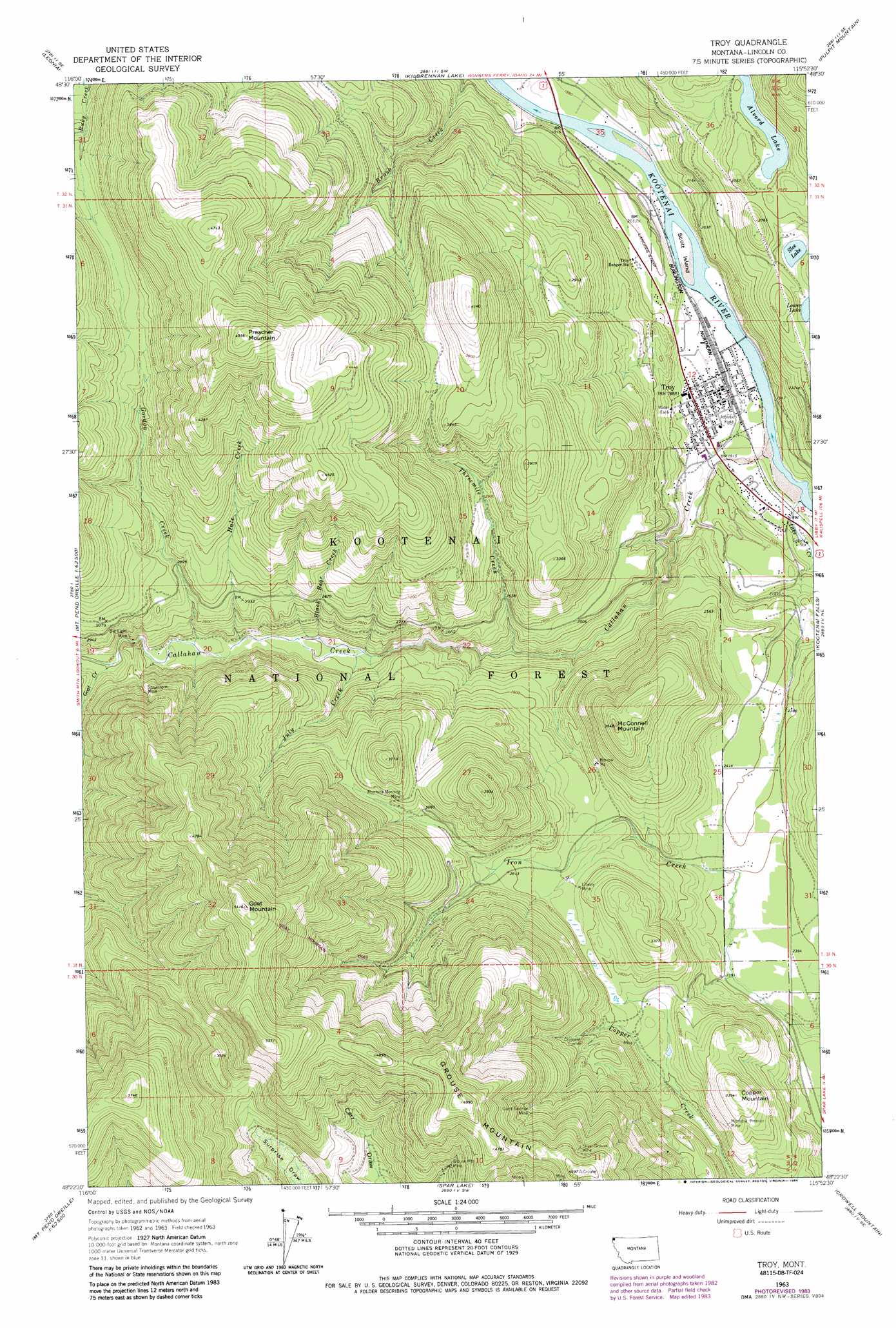
USGS Topo Quad 48115d8 - 1:24,000 scale
| Topo Map Name: | Troy |
| USGS Topo Quad ID: | 48115d8 |
| Print Size: | ca. 21 1/4" wide x 27" high |
| Southeast Coordinates: | 48.375° N latitude / 115.875° W longitude |
| Map Center Coordinates: | 48.4375° N latitude / 115.9375° W longitude |
| U.S. State: | MT |
| Filename: | o48115d8.jpg |
| Download Map JPG Image: | Troy topo map 1:24,000 scale |
| Map Type: | Topographic |
| Topo Series: | 7.5´ |
| Map Scale: | 1:24,000 |
| Source of Map Images: | United States Geological Survey (USGS) |
| Alternate Map Versions: |
Troy MT 1963, updated 1966 Download PDF Buy paper map Troy MT 1983, updated 1984 Download PDF Buy paper map Troy MT 1997, updated 2000 Download PDF Buy paper map Troy MT 2011 Download PDF Buy paper map Troy MT 2014 Download PDF Buy paper map |
| FStopo: | US Forest Service topo Troy is available: Download FStopo PDF Download FStopo TIF |
1:24,000 Topo Quads surrounding Troy
Moyie Springs |
Curley Creek |
Newton Mountain |
Sylvanite |
Flatiron Mountain |
Clifty Mountain |
Leonia |
Kilbrennan Lake |
Pulpit Mountain |
Turner Mountain |
Mount Pend Oreille |
Smith Mountain |
Troy |
Kootenai Falls |
Scenery Mountain |
Trestle Peak |
Benning Mountain |
Spar Lake |
Crowell Mountain |
Treasure Mountain |
Clark Fork |
Scotchman Peak |
Sawtooth Mountain |
Ibex Peak |
Snowshoe Peak |
> Back to 48115a1 at 1:100,000 scale
> Back to 48114a1 at 1:250,000 scale
> Back to U.S. Topo Maps home
Troy topo map: Gazetteer
Troy: Airports
Troy Airport elevation 604m 1981′Troy: Bridges
Troy Bridge elevation 566m 1856′Troy: Dams
Lake Creek Dam elevation 697m 2286′Troy: Islands
Scott Island elevation 566m 1856′Troy: Lakes
Alvord Lake elevation 787m 2582′Moose Lake elevation 755m 2477′
Slee Lake elevation 769m 2522′
Troy: Mines
Big Eight Mine elevation 842m 2762′Big Eight Mine elevation 779m 2555′
Crescent Mine elevation 933m 3061′
Crescent Tunnel elevation 933m 3061′
Giant Sunrise Mine elevation 1146m 3759′
Giant Sunrise Mine elevation 1132m 3713′
Grouse Mountain Mine elevation 1190m 3904′
Grouse Mountain Mine elevation 1187m 3894′
Grouse Mountain Number 3 Mine elevation 1364m 4475′
Grouse Mountain Number 4 Mine elevation 1291m 4235′
Grouse Mountain Number 6 Mine elevation 1187m 3894′
Grouse Mountain Number 7 Mine elevation 1304m 4278′
Hale Creek Mine elevation 1022m 3353′
Liberty Mine elevation 832m 2729′
Liberty Mine elevation 836m 2742′
Lower Hale Mine elevation 1011m 3316′
Montana Morning Mine elevation 1001m 3284′
Montana Premier Mine elevation 782m 2565′
Montana Premier Mine elevation 916m 3005′
Silver Grouse Mine elevation 1269m 4163′
Silver Grouse Mine elevation 1306m 4284′
Snowstorm Mine elevation 929m 3047′
Troy: Parks
Troy City Park elevation 581m 1906′Troy: Populated Places
Troy elevation 579m 1899′Troy: Post Offices
Troy Post Office elevation 582m 1909′Troy: Reservoirs
Troy Dam Reservoir elevation 697m 2286′Troy: Streams
Black Bear Creek elevation 730m 2395′Callahan Creek elevation 566m 1856′
Goat Creek elevation 790m 2591′
Gordon Creek elevation 763m 2503′
Hale Creek elevation 756m 2480′
July Creek elevation 718m 2355′
Lake Creek elevation 574m 1883′
Threemile Creek elevation 665m 2181′
Troy: Summits
Copper Mountain elevation 1030m 3379′Goat Mountain elevation 1650m 5413′
Grouse Mountain elevation 1519m 4983′
McConnell Mountain elevation 1111m 3645′
Preacher Mountain elevation 1506m 4940′
Troy: Trails
Goat Mountain Trail elevation 1354m 4442′Troy: Wells
31N33W18CCAA01 Well elevation 582m 1909′31N34W01CCCD01 Well elevation 611m 2004′
31N34W13BCAA01 Well elevation 618m 2027′
31N34W36ABDC01 Well elevation 734m 2408′
32N34W35DCCD01 Well elevation 607m 1991′
Troy digital topo map on disk
Buy this Troy topo map showing relief, roads, GPS coordinates and other geographical features, as a high-resolution digital map file on DVD: