Keysville Topo Map Florida
To zoom in, hover over the map of Keysville
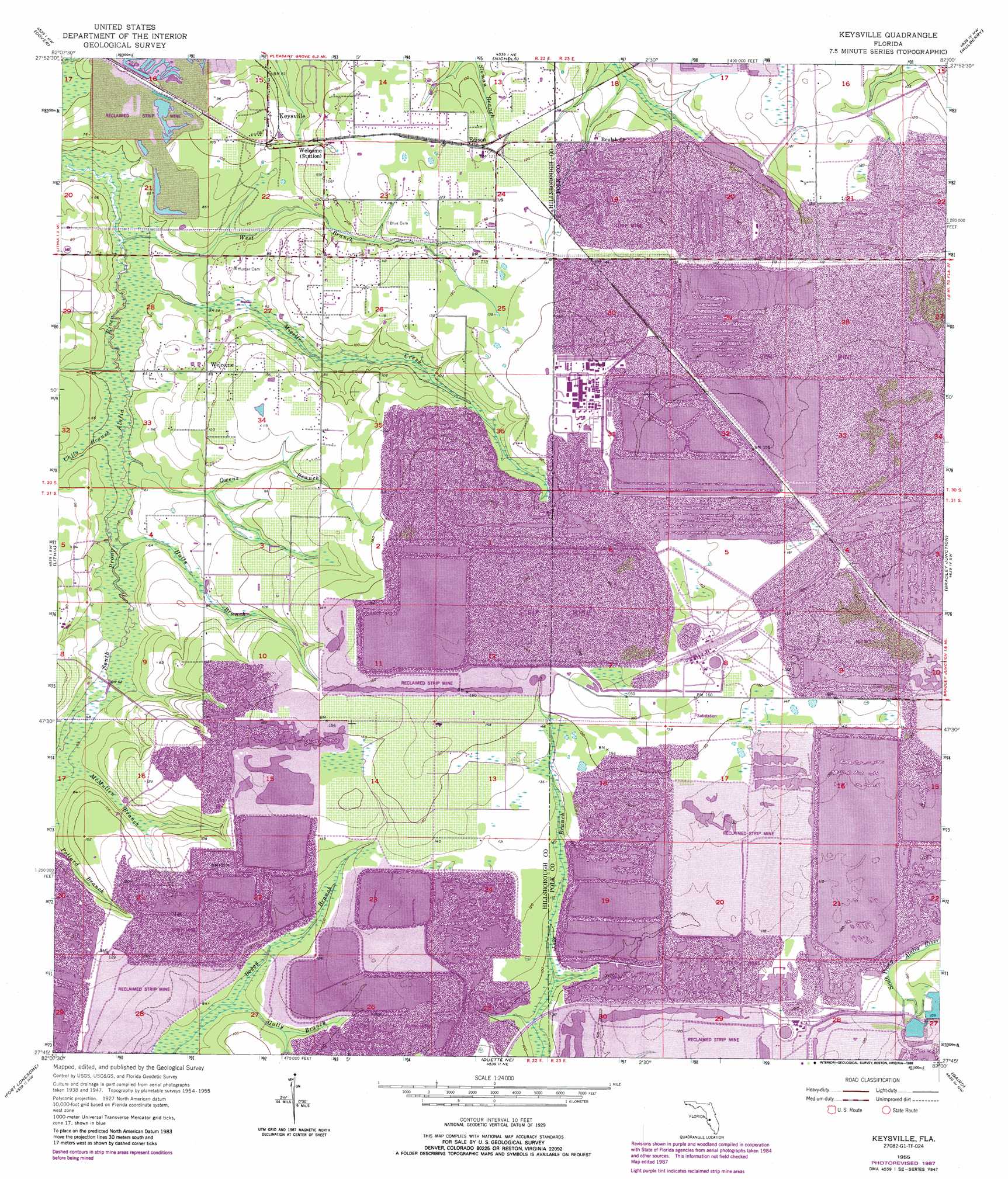
USGS Topo Quad 27082g1 - 1:24,000 scale
| Topo Map Name: | Keysville |
| USGS Topo Quad ID: | 27082g1 |
| Print Size: | ca. 21 1/4" wide x 27" high |
| Southeast Coordinates: | 27.75° N latitude / 82° W longitude |
| Map Center Coordinates: | 27.8125° N latitude / 82.0625° W longitude |
| U.S. State: | FL |
| Filename: | O27082G1.jpg |
| Download Map JPG Image: | Keysville topo map 1:24,000 scale |
| Map Type: | Topographic |
| Topo Series: | 7.5´ |
| Map Scale: | 1:24,000 |
| Source of Map Images: | United States Geological Survey (USGS) |
| Alternate Map Versions: |
Keysville FL 1955, updated 1956 Download PDF Buy paper map Keysville FL 1955, updated 1968 Download PDF Buy paper map Keysville FL 1955, updated 1973 Download PDF Buy paper map Keysville FL 1955, updated 1988 Download PDF Buy paper map Keysville FL 2012 Download PDF Buy paper map Keysville FL 2015 Download PDF Buy paper map |
1:24,000 Topo Quads surrounding Keysville
Thonotosassa |
Plant City West |
Plant City East |
Lakeland |
Auburndale |
Brandon |
Dover |
Nichols |
Mulberry |
Bartow |
Riverview |
Lithia |
Keysville |
Bradley Junction |
Homeland |
Wimauma |
Fort Lonesome |
Duette Ne |
Baird |
Bowling Green |
Rye |
Keentown |
Duette |
Fort Green |
Wauchula |
> Back to 27082e1 at 1:100,000 scale
> Back to 27082a1 at 1:250,000 scale
> Back to U.S. Topo Maps home
Keysville topo map: Gazetteer
Keysville: Guts
McMullen Branch elevation 19m 62′Keysville: Parks
Alafia River State Park elevation 12m 39′Keysville: Populated Places
Alafia Ranch elevation 18m 59′Cindy Lynn Place elevation 30m 98′
Corbett Acres elevation 26m 85′
Creightons Mizelle Creek Garden Estates elevation 25m 82′
Edge elevation 33m 108′
Edison elevation 36m 118′
Hunters Hill elevation 37m 121′
Jameson Farms elevation 26m 85′
Keysville elevation 29m 95′
Keysville Estates elevation 36m 118′
Lane Acres elevation 22m 72′
Lillibridge elevation 35m 114′
Mac Acres elevation 32m 104′
Roberts elevation 24m 78′
Rogers Ranch elevation 36m 118′
Southwood Estates elevation 28m 91′
Welcome elevation 25m 82′
Keysville: Streams
Chito Branch elevation 13m 42′Gully Branch elevation 22m 72′
Guy Branch elevation 30m 98′
Halls Branch elevation 15m 49′
Mizelle Creek elevation 12m 39′
Owens Branch elevation 13m 42′
West Branch South Prong Alafia River elevation 11m 36′
Keysville digital topo map on disk
Buy this Keysville topo map showing relief, roads, GPS coordinates and other geographical features, as a high-resolution digital map file on DVD: