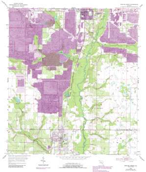
Bowling Green Topo Map Florida
To zoom in, hover over the map of Bowling Green
USGS Topo Quad 27081f7 - 1:24,000 scale
| Topo Map Name: | Bowling Green |
| USGS Topo Quad ID: | 27081f7 |
| Print Size: | ca. 21 1/4" wide x 27" high |
| Southeast Coordinates: | 27.625° N latitude / 81.75° W longitude |
| Map Center Coordinates: | 27.6875° N latitude / 81.8125° W longitude |
| U.S. State: | FL |
| Filename: | O27081F7.jpg |
| Download Map JPG Image: | Bowling Green topo map 1:24,000 scale |
| Map Type: | Topographic |
| Topo Series: | 7.5´ |
| Map Scale: | 1:24,000 |
| Source of Map Images: | United States Geological Survey (USGS) |
| Alternate Map Versions: |
Bowling Green FL 1955, updated 1956 Download PDF Buy paper map Bowling Green FL 1955, updated 1973 Download PDF Buy paper map Bowling Green FL 1955, updated 1983 Download PDF Buy paper map Bowling Green FL 1955, updated 1987 Download PDF Buy paper map Bowling Green FL 2012 Download PDF Buy paper map Bowling Green FL 2015 Download PDF Buy paper map |
1:24,000 Topo Quads surrounding Bowling Green
> Back to 27081e1 at 1:100,000 scale
> Back to 27080a1 at 1:250,000 scale
> Back to U.S. Topo Maps home
Bowling Green topo map: Gazetteer
Bowling Green: Lakes
Twomile Lake elevation 33m 108′Bowling Green: Parks
Paynes Creek Historic State Park elevation 18m 59′Bowling Green: Populated Places
Bowling Green elevation 36m 118′Christmas Tree Trailer Park elevation 33m 108′
Fort Meade Mobile Home Park elevation 35m 114′
Grace Mobile Home Park elevation 30m 98′
Hammock Lake Mobile Estates elevation 28m 91′
McDuffie Mobile Home Park elevation 36m 118′
Oakview Lakes Mobile Home Park elevation 35m 114′
Valencia Mobile Home Park elevation 34m 111′
Bowling Green: Streams
Bowlegs Creek elevation 21m 68′Crooked Drain elevation 29m 95′
Gilshey Branch elevation 18m 59′
McCullough Creek elevation 30m 98′
Mill Branch elevation 28m 91′
Whidden Creek elevation 20m 65′
Bowling Green: Summits
Sand Mountain elevation 39m 127′Bowling Green digital topo map on disk
Buy this Bowling Green topo map showing relief, roads, GPS coordinates and other geographical features, as a high-resolution digital map file on DVD:


