Nichols Topo Map Florida
To zoom in, hover over the map of Nichols
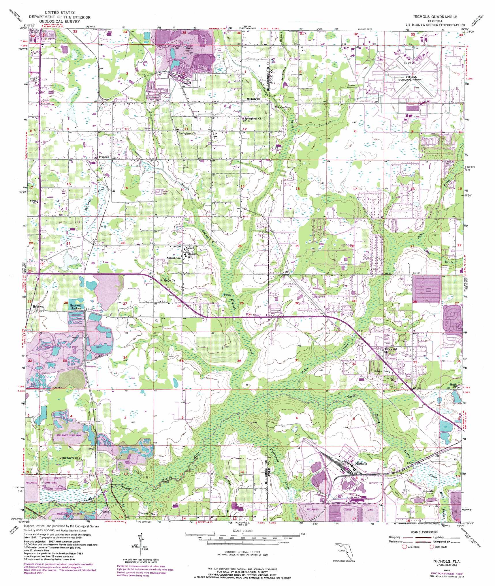
USGS Topo Quad 27082h1 - 1:24,000 scale
| Topo Map Name: | Nichols |
| USGS Topo Quad ID: | 27082h1 |
| Print Size: | ca. 21 1/4" wide x 27" high |
| Southeast Coordinates: | 27.875° N latitude / 82° W longitude |
| Map Center Coordinates: | 27.9375° N latitude / 82.0625° W longitude |
| U.S. State: | FL |
| Filename: | O27082H1.jpg |
| Download Map JPG Image: | Nichols topo map 1:24,000 scale |
| Map Type: | Topographic |
| Topo Series: | 7.5´ |
| Map Scale: | 1:24,000 |
| Source of Map Images: | United States Geological Survey (USGS) |
| Alternate Map Versions: |
Nichols FL 1955, updated 1956 Download PDF Buy paper map Nichols FL 1955, updated 1973 Download PDF Buy paper map Nichols FL 1955, updated 1988 Download PDF Buy paper map Nichols FL 1955, updated 1988 Download PDF Buy paper map Nichols FL 2012 Download PDF Buy paper map Nichols FL 2015 Download PDF Buy paper map |
1:24,000 Topo Quads surrounding Nichols
Wesley Chapel |
Zephyrhills |
Socrum |
Providence |
Polk City |
Thonotosassa |
Plant City West |
Plant City East |
Lakeland |
Auburndale |
Brandon |
Dover |
Nichols |
Mulberry |
Bartow |
Riverview |
Lithia |
Keysville |
Bradley Junction |
Homeland |
Wimauma |
Fort Lonesome |
Duette Ne |
Baird |
Bowling Green |
> Back to 27082e1 at 1:100,000 scale
> Back to 27082a1 at 1:250,000 scale
> Back to U.S. Topo Maps home
Nichols topo map: Gazetteer
Nichols: Airports
Lakeland Linder Regional Airport elevation 40m 131′South Lakeland Airport elevation 32m 104′
Nichols: Populated Places
Alafia Ridge Estates elevation 19m 62′Alderman elevation 40m 131′
Armijo Acres elevation 33m 108′
Avondale Groves elevation 36m 118′
Bailey Place Mobile Home Park elevation 34m 111′
Bealsville elevation 31m 101′
Berry Landing elevation 32m 104′
Berry Road Estates elevation 34m 111′
Brians Pond elevation 40m 131′
Busy Bee Haven Mobile Home Park elevation 38m 124′
Candy Cane Acres elevation 38m 124′
Colson Acres elevation 33m 108′
Colson Place elevation 34m 111′
Cook Estates elevation 34m 111′
Coronet elevation 41m 134′
Cowart Acres elevation 36m 118′
Cowart Oaks elevation 36m 118′
D And E Acres elevation 35m 114′
Deep Roots Farms elevation 31m 101′
Dranefield Mobile Home Park elevation 38m 124′
Dubois Acres elevation 36m 118′
Duncans Mobile Home Park elevation 33m 108′
Fasson elevation 28m 91′
Fasson South elevation 31m 101′
Gemstone Acres elevation 37m 121′
Gordon elevation 33m 108′
Gulf Sierra Farms elevation 36m 118′
Hamilton Hills elevation 36m 118′
Highland Creek elevation 26m 85′
Hopewell elevation 31m 101′
Howell Estates elevation 35m 114′
Jones Ridge elevation 36m 118′
Kayla Ranch elevation 37m 121′
Killebrew elevation 33m 108′
Knoxville Acres elevation 38m 124′
Lambert elevation 31m 101′
Larson Acres elevation 34m 111′
Layton Estates elevation 39m 127′
Lexie Lane elevation 38m 124′
McDonald Terrace elevation 43m 141′
McWetherbee Junction elevation 39m 127′
Morrell Park elevation 41m 134′
Mulberry Acres elevation 37m 121′
Mulberry Estates Mobile Home Park elevation 35m 114′
Nehaul elevation 32m 104′
Nesmith Estates elevation 39m 127′
Nichols elevation 29m 95′
Oakview Estates elevation 40m 131′
Oliver Acres elevation 37m 121′
Orange Haven elevation 36m 118′
Pams Place elevation 32m 104′
Patricks Way Estates elevation 33m 108′
Peacock Grove elevation 40m 131′
Perry Acres elevation 34m 111′
Phipps elevation 35m 114′
Piney Oaks elevation 42m 137′
Pollard Place elevation 36m 118′
Pooran elevation 31m 101′
Pratt Acres elevation 37m 121′
Pritcher Manor elevation 29m 95′
Pritcher Pines elevation 32m 104′
Ralston Acres elevation 38m 124′
Ralston Country Estates elevation 37m 121′
Ralston Woods elevation 38m 124′
Raye Ann elevation 39m 127′
Register Country Acres elevation 39m 127′
Robichaud elevation 34m 111′
Robinson Farms elevation 36m 118′
Rockin T Ranch elevation 22m 72′
Rutland Acres elevation 33m 108′
Samantha Park elevation 39m 127′
Scott Place elevation 28m 91′
Silver Maple Estates elevation 38m 124′
Simmons Acres elevation 32m 104′
Smith elevation 33m 108′
South Plant City Farms elevation 35m 114′
Sparkman Oaks elevation 38m 124′
Spring Hill Mobile Home Park elevation 32m 104′
Stockwell elevation 36m 118′
Tagliarini elevation 31m 101′
Taman Estates elevation 37m 121′
Tangerine Trails elevation 42m 137′
Taulbee Acres elevation 20m 65′
The Palms Mobile Home Park elevation 35m 114′
Thomas Hills elevation 40m 131′
Thomas Oaks elevation 31m 101′
Tower Ridge Estates elevation 36m 118′
Trapnell elevation 37m 121′
Trapnell Acres elevation 36m 118′
Trapnell East elevation 36m 118′
Trapnell Oaks elevation 38m 124′
Trapnell Place elevation 35m 114′
Turner Place elevation 40m 131′
Walden Woods elevation 42m 137′
West Texas Acres elevation 40m 131′
Wiggins Meadows elevation 35m 114′
Wiggins Trace elevation 36m 118′
Wiggs Estates elevation 31m 101′
Wild Rose elevation 36m 118′
Willow Oak elevation 34m 111′
Willow Oak II Mobile Home Park elevation 34m 111′
Windmill Pointe elevation 34m 111′
Nichols: Streams
Bird Branch elevation 27m 88′English Creek elevation 17m 55′
Hamilton Branch elevation 30m 98′
Howell Branch elevation 19m 62′
Lake Drain elevation 26m 85′
Morgan Creek elevation 28m 91′
Poley Creek elevation 18m 59′
Sloman Branch elevation 17m 55′
Thirtymile Creek elevation 17m 55′
Nichols: Swamps
Moccasin Pond elevation 36m 118′Nichols digital topo map on disk
Buy this Nichols topo map showing relief, roads, GPS coordinates and other geographical features, as a high-resolution digital map file on DVD: