Lithia Topo Map Florida
To zoom in, hover over the map of Lithia
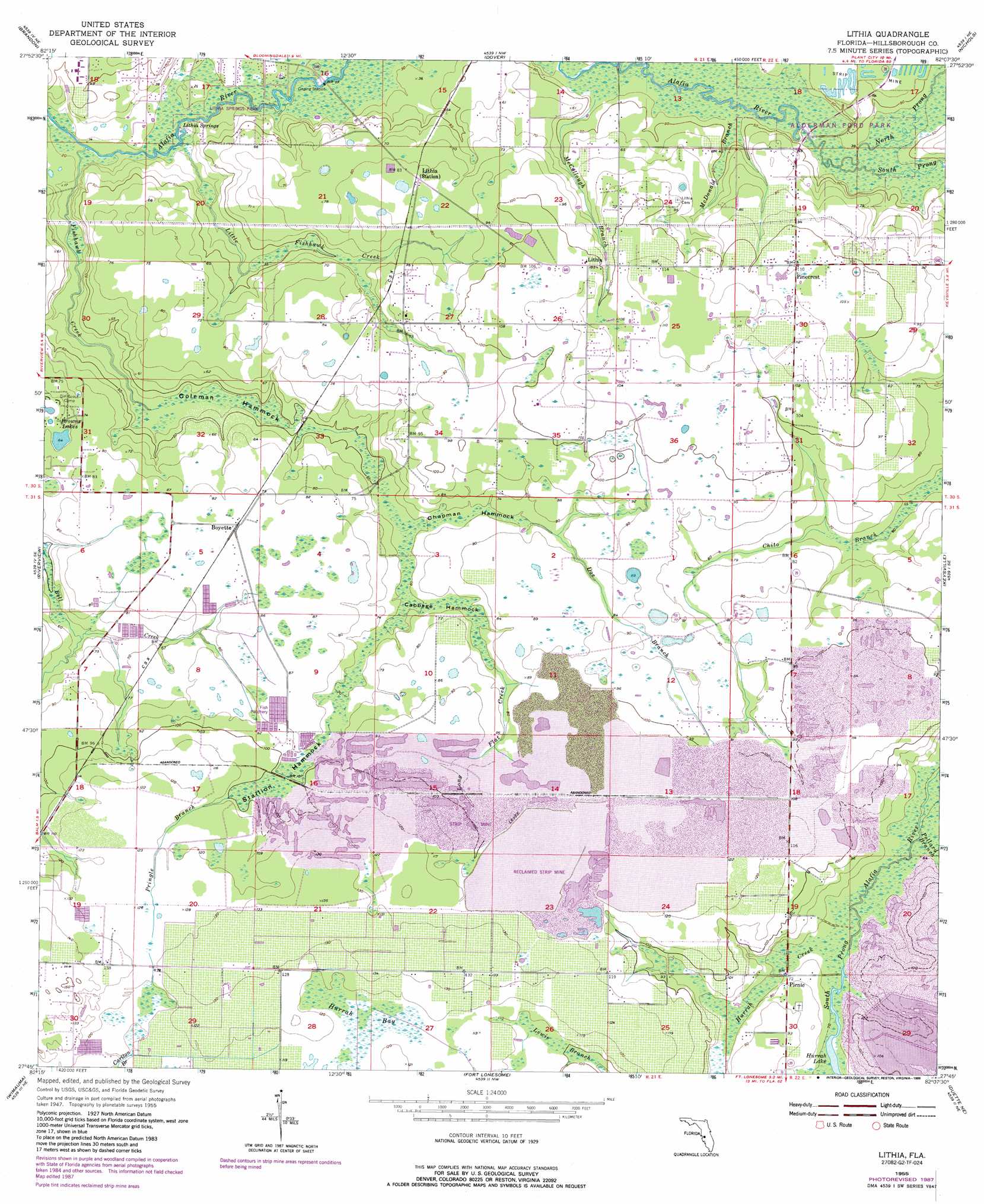
USGS Topo Quad 27082g2 - 1:24,000 scale
| Topo Map Name: | Lithia |
| USGS Topo Quad ID: | 27082g2 |
| Print Size: | ca. 21 1/4" wide x 27" high |
| Southeast Coordinates: | 27.75° N latitude / 82.125° W longitude |
| Map Center Coordinates: | 27.8125° N latitude / 82.1875° W longitude |
| U.S. State: | FL |
| Filename: | O27082G2.jpg |
| Download Map JPG Image: | Lithia topo map 1:24,000 scale |
| Map Type: | Topographic |
| Topo Series: | 7.5´ |
| Map Scale: | 1:24,000 |
| Source of Map Images: | United States Geological Survey (USGS) |
| Alternate Map Versions: |
Lithia FL 1955, updated 1956 Download PDF Buy paper map Lithia FL 1955, updated 1973 Download PDF Buy paper map Lithia FL 1955, updated 1983 Download PDF Buy paper map Lithia FL 1955, updated 1988 Download PDF Buy paper map Lithia FL 2012 Download PDF Buy paper map Lithia FL 2015 Download PDF Buy paper map |
1:24,000 Topo Quads surrounding Lithia
Sulphur Springs |
Thonotosassa |
Plant City West |
Plant City East |
Lakeland |
Tampa |
Brandon |
Dover |
Nichols |
Mulberry |
Gibsonton |
Riverview |
Lithia |
Keysville |
Bradley Junction |
Ruskin |
Wimauma |
Fort Lonesome |
Duette Ne |
Baird |
Parrish |
Rye |
Keentown |
Duette |
Fort Green |
> Back to 27082e1 at 1:100,000 scale
> Back to 27082a1 at 1:250,000 scale
> Back to U.S. Topo Maps home
Lithia topo map: Gazetteer
Lithia: Islands
Cabbage Hammock elevation 20m 65′Chapman Hammock elevation 21m 68′
Coleman Hammock elevation 10m 32′
Stallion Hammock elevation 28m 91′
Lithia: Lakes
Browns Lakes elevation 19m 62′Hurrah Lake elevation 20m 65′
Lithia: Parks
Aldermans Ford Park elevation 10m 32′Lithia: Populated Places
Aldermans Ford elevation 19m 62′Boyette elevation 25m 82′
Candlewood Acres elevation 33m 108′
Capitano Estates elevation 21m 68′
Climer Estates elevation 29m 95′
Conway Estates elevation 28m 91′
Devore Gundog and Equestrian Estates elevation 33m 108′
Dixon Country Estates elevation 32m 104′
Doe Branch elevation 27m 88′
Doe Creek Reserve elevation 28m 91′
Dorman Acres elevation 26m 85′
Dorman Meadows elevation 34m 111′
Dorman Ranch elevation 31m 101′
Fish Hawk elevation 19m 62′
Fish Hawk Farms elevation 20m 65′
Fish Hawk Trails elevation 26m 85′
Fishhawk Ranch elevation 23m 75′
Great Oaks elevation 29m 95′
Hammock Oaks Reserve elevation 27m 88′
Hendry Estates elevation 36m 118′
Hinton Ranch elevation 18m 59′
Holland Acres elevation 27m 88′
Hood Manor Estates elevation 18m 59′
Jacobs Run elevation 34m 111′
Karlson Acres elevation 24m 78′
Kavita Estates elevation 33m 108′
Lightfoot Acres elevation 33m 108′
Lithia elevation 31m 101′
Lithia Estates elevation 33m 108′
Lithia Pines elevation 22m 72′
Lithia Ranch elevation 30m 98′
Lynn Estates elevation 24m 78′
Mannhurst Oak Manors elevation 28m 91′
Martindale Acres elevation 24m 78′
Miller Estates elevation 33m 108′
Natures Place elevation 33m 108′
Parkside Village elevation 22m 72′
Pinecrest elevation 33m 108′
Princess Estates elevation 33m 108′
Serenity Acres elevation 33m 108′
Shelley Lakes Estates elevation 37m 121′
South County Estates elevation 35m 114′
Streetman Acres elevation 15m 49′
Tierra de Amigos elevation 33m 108′
Villages At Lithia elevation 40m 131′
Wendel Wood elevation 27m 88′
Lithia: Post Offices
Lithia Post Office elevation 33m 108′Lithia: Springs
Lithia Springs elevation 3m 9′Lithia: Streams
Doe Branch elevation 21m 68′Fishhawk Creek elevation 2m 6′
Hurrah Creek elevation 20m 65′
Little Fishhawk Creek elevation 3m 9′
Long Flat Creek elevation 21m 68′
McCollough Branch elevation 9m 29′
McDonald Branch elevation 9m 29′
North Prong Alafia River elevation 9m 29′
Pollard Branch elevation 18m 59′
Pringle Branch elevation 30m 98′
South Prong Alafia River elevation 9m 29′
Lithia: Swamps
Hurrah Bay elevation 35m 114′Lithia digital topo map on disk
Buy this Lithia topo map showing relief, roads, GPS coordinates and other geographical features, as a high-resolution digital map file on DVD: