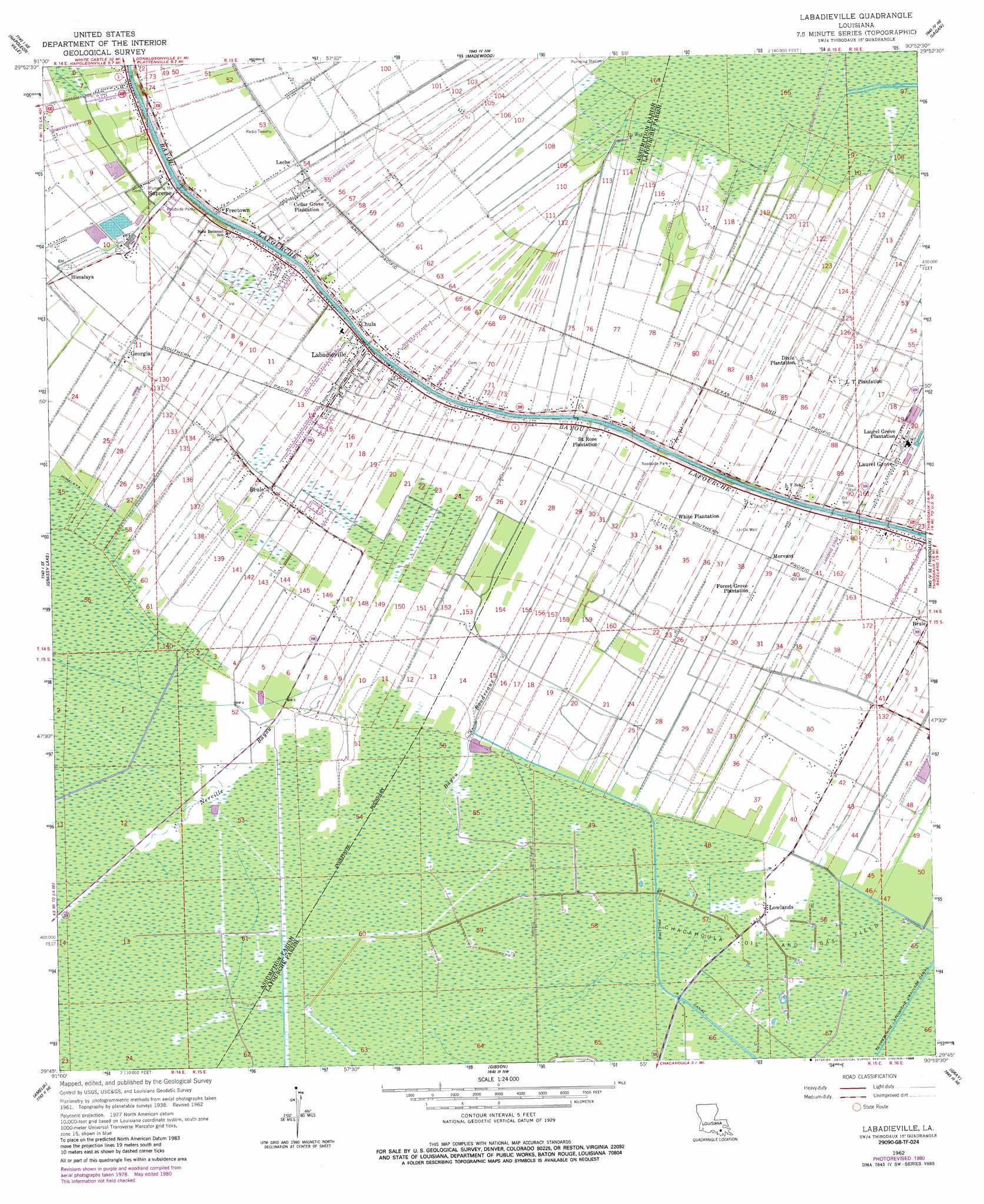
Labadieville Topo Map Louisiana
To zoom in, hover over the map of Labadieville
USGS Topo Quad 29090g8 - 1:24,000 scale
| Topo Map Name: | Labadieville |
| USGS Topo Quad ID: | 29090g8 |
| Print Size: | ca. 21 1/4" wide x 27" high |
| Southeast Coordinates: | 29.75° N latitude / 90.875° W longitude |
| Map Center Coordinates: | 29.8125° N latitude / 90.9375° W longitude |
| U.S. State: | LA |
| Filename: | o29090g8.jpg |
| Download Map JPG Image: | Labadieville topo map 1:24,000 scale |
| Map Type: | Topographic |
| Topo Series: | 7.5´ |
| Map Scale: | 1:24,000 |
| Source of Map Images: | United States Geological Survey (USGS) |
| Alternate Map Versions: |
Labadieville LA 1938 Download PDF Buy paper map Labadieville LA 1962, updated 1963 Download PDF Buy paper map Labadieville LA 1962, updated 1970 Download PDF Buy paper map Labadieville LA 1962, updated 1981 Download PDF Buy paper map Labadieville LA 1962, updated 1986 Download PDF Buy paper map Labadieville LA 2012 Download PDF Buy paper map Labadieville LA 2015 Download PDF Buy paper map |
1:24,000 Topo Quads surrounding Labadieville
Lone Star |
Belle Rose |
Donaldsonville |
Convent |
Lutcher |
Pierre Part |
Napoleonville |
Madewood |
Lagan |
Lower Vacherie |
Napoleonville Sw |
Grassy Lake |
Labadieville |
Thibodaux |
Kraemer |
Morgan City |
Amelia |
Gibson |
Gray |
Savoie |
Morgan City Sw |
Morgan City Se |
Bayou Cocodrie |
Humphreys |
Houma |
> Back to 29090e1 at 1:100,000 scale
> Back to 29090a1 at 1:250,000 scale
> Back to U.S. Topo Maps home
Labadieville topo map: Gazetteer
Labadieville: Canals
Phillips Canal elevation 1m 3′Labadieville: Dams
Supreme Sugar Pond Dam elevation 4m 13′Labadieville: Oilfields
Laurel Grove Gas Field elevation 4m 13′North Laurel Grove Gas Field elevation 2m 6′
Saint John Gas Field elevation 2m 6′
Labadieville: Populated Places
Brule elevation 3m 9′Brule elevation 3m 9′
Cedar Grove Plantation elevation 5m 16′
Chula elevation 5m 16′
Dixie Plantation elevation 3m 9′
Freetown elevation 5m 16′
Georgia elevation 2m 6′
Himalaya elevation 3m 9′
L T Plantation elevation 3m 9′
Labadieville elevation 5m 16′
Laurel Grove elevation 3m 9′
Laurel Grove Plantation elevation 2m 6′
Leche elevation 3m 9′
Lowlands elevation 1m 3′
Morvant elevation 4m 13′
Saint Rose Plantation elevation 5m 16′
Supreme elevation 5m 16′
White Plantation elevation 3m 9′
Labadieville: Post Offices
Labadieville Post Office elevation 5m 16′Supreme Post Office elevation 5m 16′
Labadieville: Reservoirs
Supreme Sugar Pond elevation 4m 13′Labadieville: Streams
Bayou Boudreaux elevation 1m 3′Nerville Bayou elevation 1m 3′
Labadieville digital topo map on disk
Buy this Labadieville topo map showing relief, roads, GPS coordinates and other geographical features, as a high-resolution digital map file on DVD: