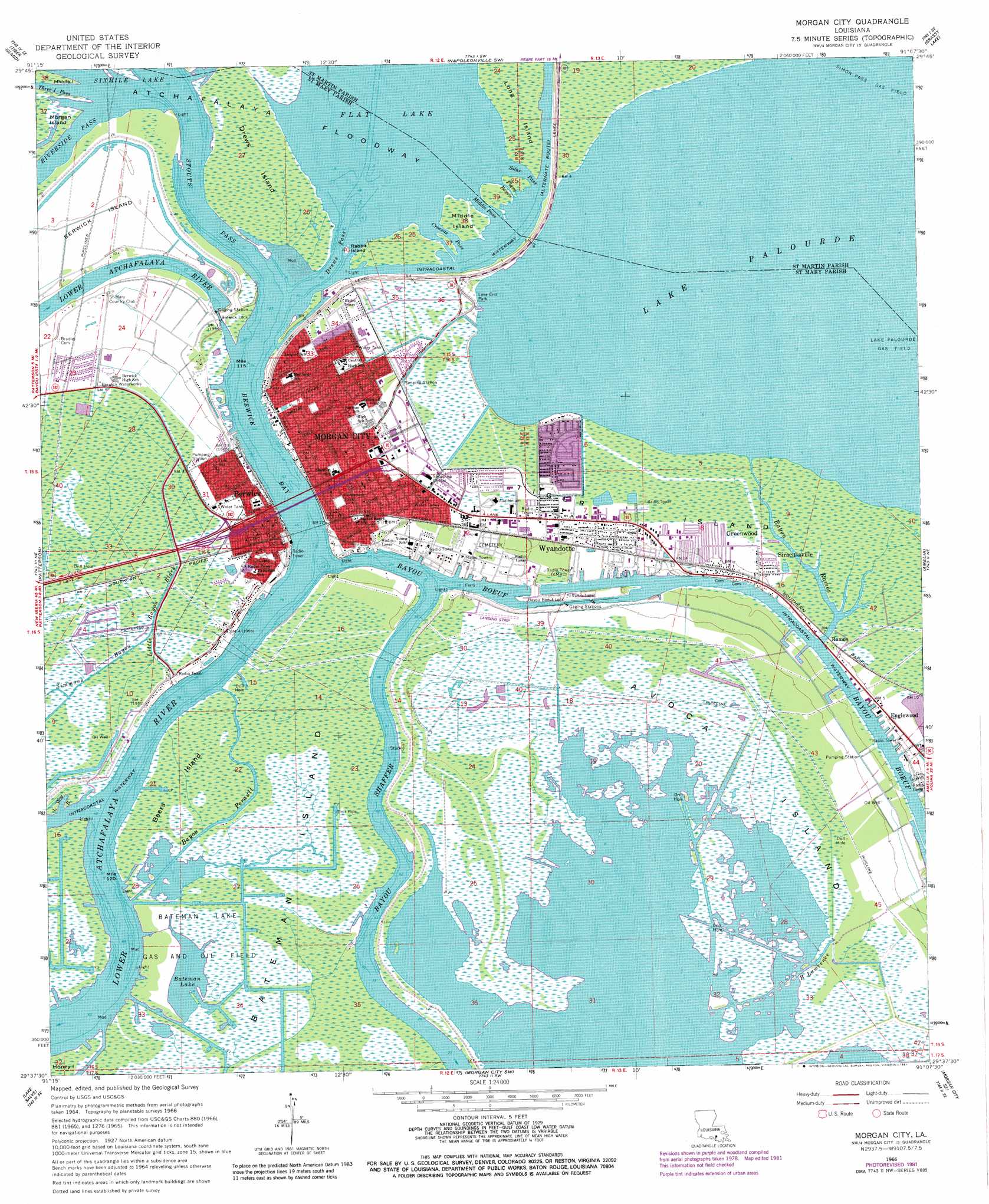
Morgan City Topo Map Louisiana
To zoom in, hover over the map of Morgan City
USGS Topo Quad 29091f2 - 1:24,000 scale
| Topo Map Name: | Morgan City |
| USGS Topo Quad ID: | 29091f2 |
| Print Size: | ca. 21 1/4" wide x 27" high |
| Southeast Coordinates: | 29.625° N latitude / 91.125° W longitude |
| Map Center Coordinates: | 29.6875° N latitude / 91.1875° W longitude |
| U.S. State: | LA |
| Filename: | o29091f2.jpg |
| Download Map JPG Image: | Morgan City topo map 1:24,000 scale |
| Map Type: | Topographic |
| Topo Series: | 7.5´ |
| Map Scale: | 1:24,000 |
| Source of Map Images: | United States Geological Survey (USGS) |
| Alternate Map Versions: |
Morgan City LA 1966, updated 1967 Download PDF Buy paper map Morgan City LA 1966, updated 1981 Download PDF Buy paper map Morgan City LA 1994, updated 1998 Download PDF Buy paper map Morgan City LA 2012 Download PDF Buy paper map Morgan City LA 2015 Download PDF Buy paper map |
1:24,000 Topo Quads surrounding Morgan City
Centerville Nw |
Centerville Ne |
Pierre Part |
Napoleonville |
Madewood |
Centerville |
Tiger Island |
Napoleonville Sw |
Grassy Lake |
Labadieville |
North Bend |
Patterson |
Morgan City |
Amelia |
Gibson |
Belle Isle |
Lake Salve |
Morgan City Sw |
Morgan City Se |
Bayou Cocodrie |
Point Au Fer Ne |
Plumb Bayou |
Carencro Bayou |
Lake Penchant |
> Back to 29091e1 at 1:100,000 scale
> Back to 29090a1 at 1:250,000 scale
> Back to U.S. Topo Maps home
Morgan City topo map: Gazetteer
Morgan City: Airports
Berwick Shore Base Heliport elevation 2m 6′Cagc Berwick Heliport elevation 1m 3′
Kerr McGee Heliport elevation 2m 6′
Lakewood Hospital Heliport elevation 1m 3′
Marine Shale Processors Incorporated Heliport elevation 1m 3′
Mobil Heliport elevation 1m 3′
Oxy USA Incorporated Heliport elevation 1m 3′
Shell Morgan City Heliport elevation 2m 6′
Texaco Heliport elevation 2m 6′
The Offshore Telephone Company Heliport elevation 0m 0′
Morgan City: Bays
Berwick Bay elevation 1m 3′Morgan City: Capes
Stouts Point elevation 1m 3′Morgan City: Channels
Croesus Pass elevation 1m 3′Drews Pass elevation 1m 3′
Middle Pass elevation 1m 3′
Solar Pass elevation 1m 3′
Stouts Pass elevation 1m 3′
Morgan City: Dams
Bayou Boef Lock elevation 2m 6′Berwick Lock elevation 1m 3′
Morgan City: Islands
Avoca Island elevation 1m 3′Bateman Island elevation 0m 0′
Beers Island elevation 1m 3′
Drews Island elevation 1m 3′
Long Island elevation 1m 3′
Middle Island elevation 1m 3′
Rabbit Island elevation 1m 3′
Tiger Island elevation 1m 3′
Morgan City: Lakes
Bateman Lake elevation 0m 0′Lake Palourde elevation 0m 0′
Morgan City: Oilfields
Bateman Lake Gas and Oil Field elevation 0m 0′Wyandotte Gas Field elevation 1m 3′
Morgan City: Parks
Benny Spinella Park elevation 1m 3′Fort Star Historical Market elevation 2m 6′
Jimmy Magee Park elevation 0m 0′
Lake End Park elevation 1m 3′
Lawrence Park elevation 3m 9′
M E Norman Park elevation 2m 6′
Morgan City Historic District elevation 2m 6′
Morgan City Stadium elevation 1m 3′
Pharr Park elevation 1m 3′
Willie Evans Park elevation 0m 0′
Young Memorial Park elevation 2m 6′
Morgan City: Populated Places
Avoca elevation 2m 6′Berwick elevation 1m 3′
Englewood elevation 0m 0′
Fairville elevation 3m 9′
Greenwood elevation 2m 6′
Morgan City elevation 2m 6′
Ramos elevation 2m 6′
Siracusaville elevation 1m 3′
Wyandotte elevation 2m 6′
Morgan City: Post Offices
Berwick Post Office elevation 2m 6′Morgan City Post Office elevation 1m 3′
Morgan City: Streams
Bayou Boeuf elevation 1m 3′Bayou Perault elevation 0m 0′
Bayou Ramos elevation 0m 0′
Bayou Traine elevation 0m 0′
Little Bayou Black elevation 0m 0′
Little Wax Bayou elevation 0m 0′
Pique Bayou elevation 1m 3′
Morgan City digital topo map on disk
Buy this Morgan City topo map showing relief, roads, GPS coordinates and other geographical features, as a high-resolution digital map file on DVD: