Harleston Topo Map Mississippi
To zoom in, hover over the map of Harleston
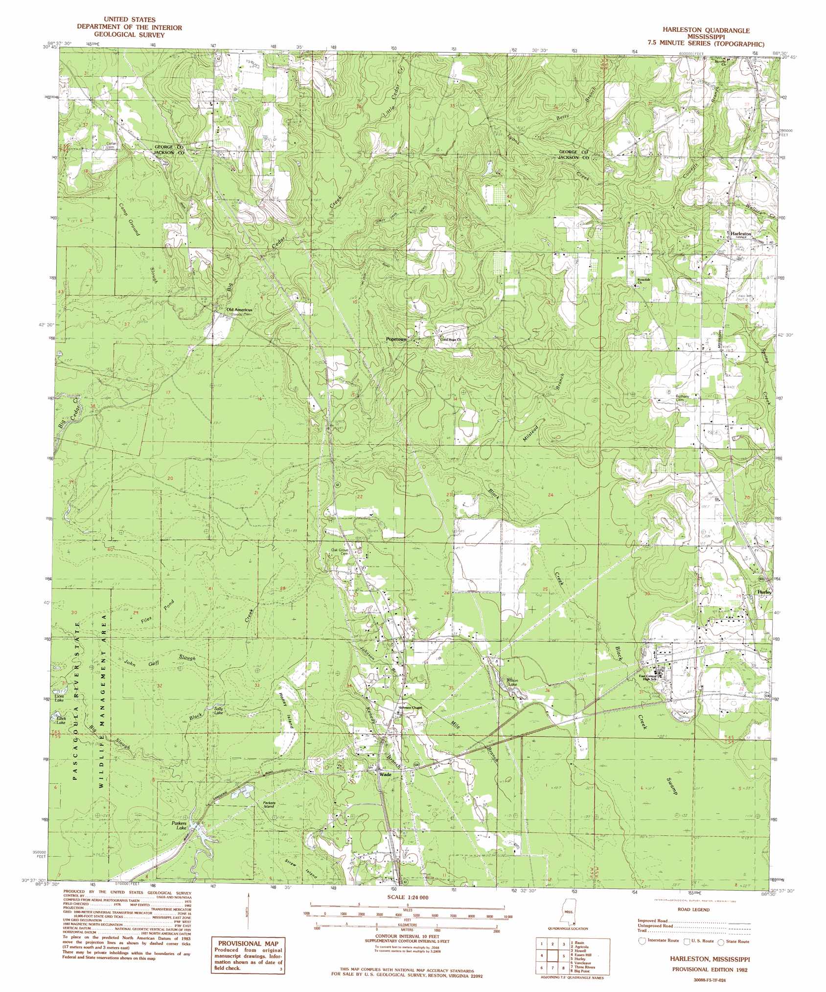
USGS Topo Quad 30088f5 - 1:24,000 scale
| Topo Map Name: | Harleston |
| USGS Topo Quad ID: | 30088f5 |
| Print Size: | ca. 21 1/4" wide x 27" high |
| Southeast Coordinates: | 30.625° N latitude / 88.5° W longitude |
| Map Center Coordinates: | 30.6875° N latitude / 88.5625° W longitude |
| U.S. State: | MS |
| Filename: | o30088f5.jpg |
| Download Map JPG Image: | Harleston topo map 1:24,000 scale |
| Map Type: | Topographic |
| Topo Series: | 7.5´ |
| Map Scale: | 1:24,000 |
| Source of Map Images: | United States Geological Survey (USGS) |
| Alternate Map Versions: |
Harleston MS 1982, updated 1982 Download PDF Buy paper map Harleston MS 1982, updated 1982 Download PDF Buy paper map Harleston MS 2012 Download PDF Buy paper map Harleston MS 2015 Download PDF Buy paper map |
1:24,000 Topo Quads surrounding Harleston
Avent |
Merrill |
Lucedale |
Earlville |
Georgetown |
Benndale |
Basin |
Agricola |
Howell |
Semmes |
Vestry |
Easen Hill |
Harleston |
Hurley |
Tanner Williams |
Latimer |
Vancleave |
Three Rivers |
Big Point |
Saint Elmo |
Ocean Springs |
Gautier North |
Pascagoula North |
Kreole |
Grand Bay |
> Back to 30088e1 at 1:100,000 scale
> Back to 30088a1 at 1:250,000 scale
> Back to U.S. Topo Maps home
Harleston topo map: Gazetteer
Harleston: Dams
Howell Lake Dam elevation 33m 108′Harleston: Guts
Black Creek Slough elevation 3m 9′Camp Ground Slough elevation 2m 6′
John Goff Slough elevation -3m -10′
Harleston: Islands
Gopher Island elevation 5m 16′Parkers Island elevation 2m 6′
Straw Island elevation 2m 6′
Harleston: Lakes
Files Pond (historical) elevation -4m -14′Lices Lake elevation -1m -4′
Parkers Lake elevation 3m 9′
Wilson Lake elevation 11m 36′
Harleston: Populated Places
Harleston elevation 38m 124′Old Americus elevation 8m 26′
Popetown elevation 32m 104′
Wade elevation 13m 42′
Harleston: Reservoirs
Sally Lake elevation 0m 0′Harleston: Streams
Betsy Branch elevation 22m 72′Cowerts Branch elevation 21m 68′
Johnson Branch elevation 4m 13′
Kenedy Branch elevation 2m 6′
Little Cedar Creek elevation 15m 49′
Mile Branch elevation 11m 36′
Milstead Branch elevation 10m 32′
Harleston: Swamps
Black Creek Swamp elevation 10m 32′Harleston digital topo map on disk
Buy this Harleston topo map showing relief, roads, GPS coordinates and other geographical features, as a high-resolution digital map file on DVD:
Gulf Coast (LA, MS, AL, FL) & Southwestern Georgia
Buy digital topo maps: Gulf Coast (LA, MS, AL, FL) & Southwestern Georgia
 & Southwestern Georgia map DVD")