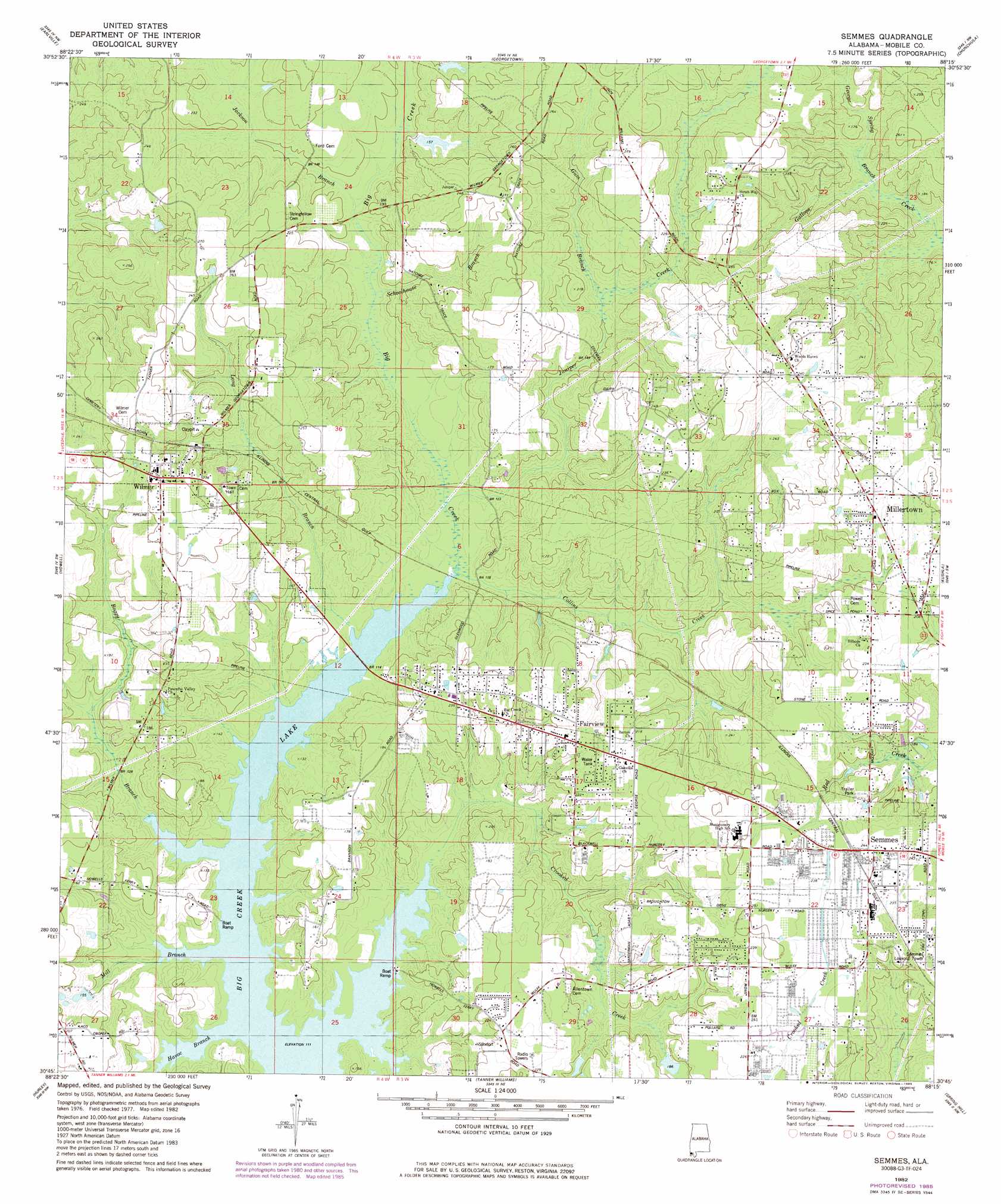
Semmes Topo Map Alabama
To zoom in, hover over the map of Semmes
USGS Topo Quad 30088g3 - 1:24,000 scale
| Topo Map Name: | Semmes |
| USGS Topo Quad ID: | 30088g3 |
| Print Size: | ca. 21 1/4" wide x 27" high |
| Southeast Coordinates: | 30.75° N latitude / 88.25° W longitude |
| Map Center Coordinates: | 30.8125° N latitude / 88.3125° W longitude |
| U.S. State: | AL |
| Filename: | o30088g3.jpg |
| Download Map JPG Image: | Semmes topo map 1:24,000 scale |
| Map Type: | Topographic |
| Topo Series: | 7.5´ |
| Map Scale: | 1:24,000 |
| Source of Map Images: | United States Geological Survey (USGS) |
| Alternate Map Versions: |
Semmes AL 1982, updated 1982 Download PDF Buy paper map Semmes AL 1982, updated 1985 Download PDF Buy paper map Semmes AL 2011 Download PDF Buy paper map Semmes AL 2014 Download PDF Buy paper map |
1:24,000 Topo Quads surrounding Semmes
Vernal |
Brown Town |
Citronelle West |
Citronelle East |
Mount Vernon |
Lucedale |
Earlville |
Georgetown |
Chunchula |
Creola |
Agricola |
Howell |
Semmes |
Kushla |
Chickasaw |
Harleston |
Hurley |
Tanner Williams |
Spring Hill |
Mobile |
Three Rivers |
Big Point |
Saint Elmo |
Theodore |
Hollingers Island |
> Back to 30088e1 at 1:100,000 scale
> Back to 30088a1 at 1:250,000 scale
> Back to U.S. Topo Maps home
Semmes topo map: Gazetteer
Semmes: Airports
Mary G Montgomery High School Airport elevation 74m 242′Semmes: Populated Places
Churchill Downs elevation 66m 216′Fairview elevation 68m 223′
Lott elevation 66m 216′
Millertown elevation 67m 219′
Semmes elevation 75m 246′
Warley elevation 74m 242′
Wilmer elevation 76m 249′
Semmes: Post Offices
Semmes Post Office (historical) elevation 74m 242′Wilmer Post Office elevation 76m 249′
Semmes: Streams
Boggy Branch elevation 34m 111′Collins Creek elevation 34m 111′
Crooked Creek elevation 34m 111′
George Spring Branch elevation 35m 114′
Gum Branch elevation 48m 157′
Havoc Branch elevation 34m 111′
Jackson Branch elevation 40m 131′
Juniper Creek elevation 36m 118′
Long Branch elevation 34m 111′
Mill Branch elevation 34m 111′
Schoolhouse Branch elevation 40m 131′
Semmes digital topo map on disk
Buy this Semmes topo map showing relief, roads, GPS coordinates and other geographical features, as a high-resolution digital map file on DVD:
Gulf Coast (LA, MS, AL, FL) & Southwestern Georgia
Buy digital topo maps: Gulf Coast (LA, MS, AL, FL) & Southwestern Georgia
 & Southwestern Georgia map DVD")