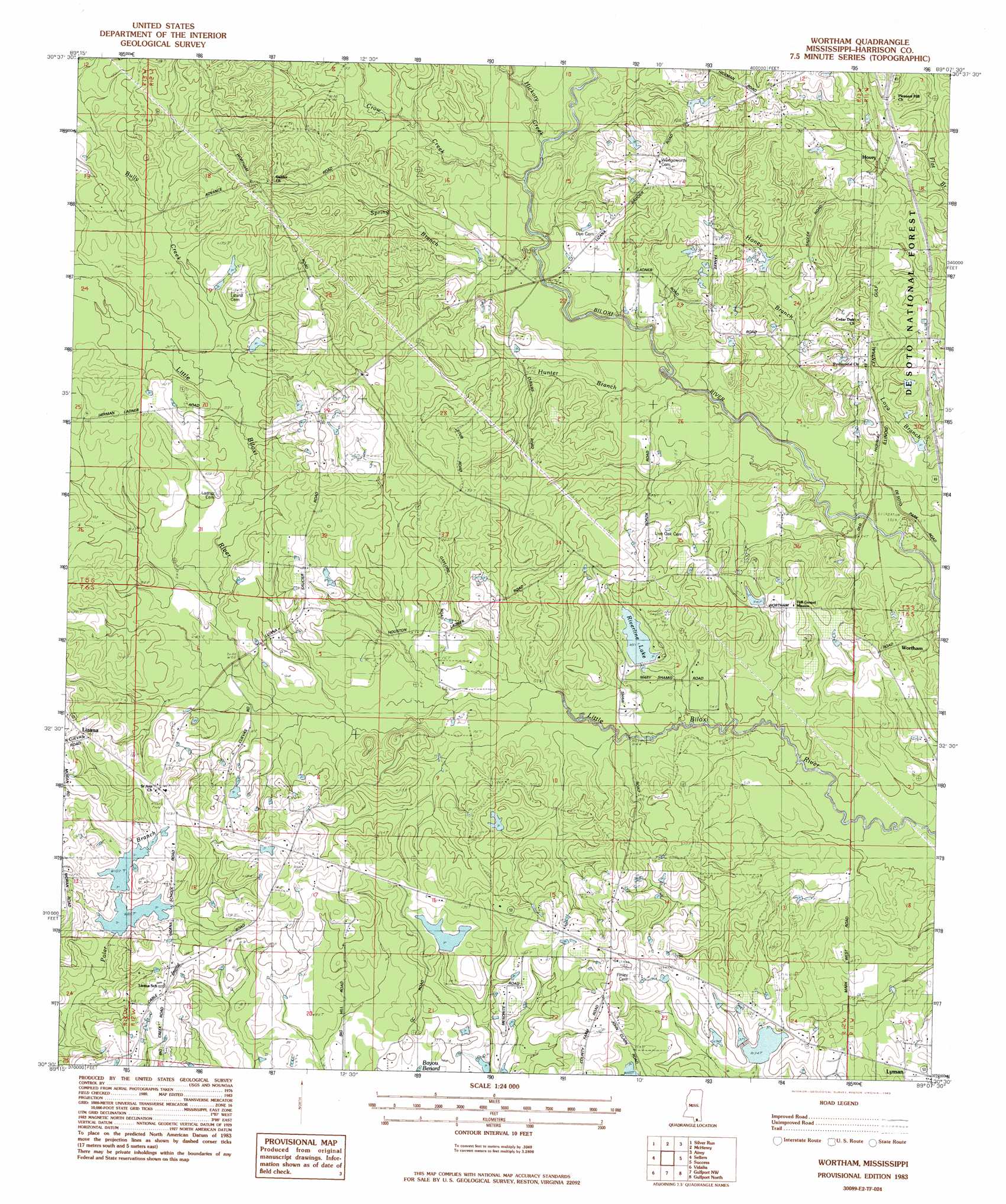
Wortham Topo Map Mississippi
To zoom in, hover over the map of Wortham
USGS Topo Quad 30089e2 - 1:24,000 scale
| Topo Map Name: | Wortham |
| USGS Topo Quad ID: | 30089e2 |
| Print Size: | ca. 21 1/4" wide x 27" high |
| Southeast Coordinates: | 30.5° N latitude / 89.125° W longitude |
| Map Center Coordinates: | 30.5625° N latitude / 89.1875° W longitude |
| U.S. State: | MS |
| Filename: | o30089e2.jpg |
| Download Map JPG Image: | Wortham topo map 1:24,000 scale |
| Map Type: | Topographic |
| Topo Series: | 7.5´ |
| Map Scale: | 1:24,000 |
| Source of Map Images: | United States Geological Survey (USGS) |
| Alternate Map Versions: |
Wortham MS 1983, updated 1983 Download PDF Buy paper map Wortham MS 2000, updated 2002 Download PDF Buy paper map Wortham MS 2012 Download PDF Buy paper map Wortham MS 2015 Download PDF Buy paper map |
| FStopo: | US Forest Service topo Wortham is available: Download FStopo PDF Download FStopo TIF |
1:24,000 Topo Quads surrounding Wortham
Big Swamp |
Browns Lake |
Wiggins |
Whites Crossing |
Ramsey Springs |
Savannah |
Silver Run |
Mchenry |
Airey |
Beatrice |
Necaise |
Sellers |
Wortham |
Success |
White Plains |
Kiln |
Vidalia |
Gulfport Nw |
Gulfport North |
Biloxi |
Waveland |
Bay Saint Louis |
Pass Christian |
Gulfport South |
> Back to 30089e1 at 1:100,000 scale
> Back to 30088a1 at 1:250,000 scale
> Back to U.S. Topo Maps home
Wortham topo map: Gazetteer
Wortham: Dams
Cal Maine Lake Dam elevation 41m 134′Fulton Pond Dam elevation 37m 121′
Harrison County Farm Lake Dam elevation 41m 134′
Ladner Lake Dam elevation 31m 101′
Morgan Lake Dam elevation 36m 118′
Morris Lake Dam elevation 28m 91′
Paul McGill Lake Dam elevation 28m 91′
Riverline Lake Dam elevation 25m 82′
Scarborough Lake Dam elevation 29m 95′
Windy Hill Lake Dam elevation 25m 82′
Wortham: Parks
Big Biloxi Recreation Area elevation 15m 49′Wortham: Populated Places
Hovey elevation 33m 108′Wortham elevation 25m 82′
Wortham: Reservoirs
Riverline Lake elevation 24m 78′Wortham: Streams
Bully Creek elevation 30m 98′Crow Creek elevation 16m 52′
Hickory Creek elevation 16m 52′
Honey Branch elevation 15m 49′
Wortham digital topo map on disk
Buy this Wortham topo map showing relief, roads, GPS coordinates and other geographical features, as a high-resolution digital map file on DVD:
Gulf Coast (LA, MS, AL, FL) & Southwestern Georgia
Buy digital topo maps: Gulf Coast (LA, MS, AL, FL) & Southwestern Georgia
 & Southwestern Georgia map DVD")