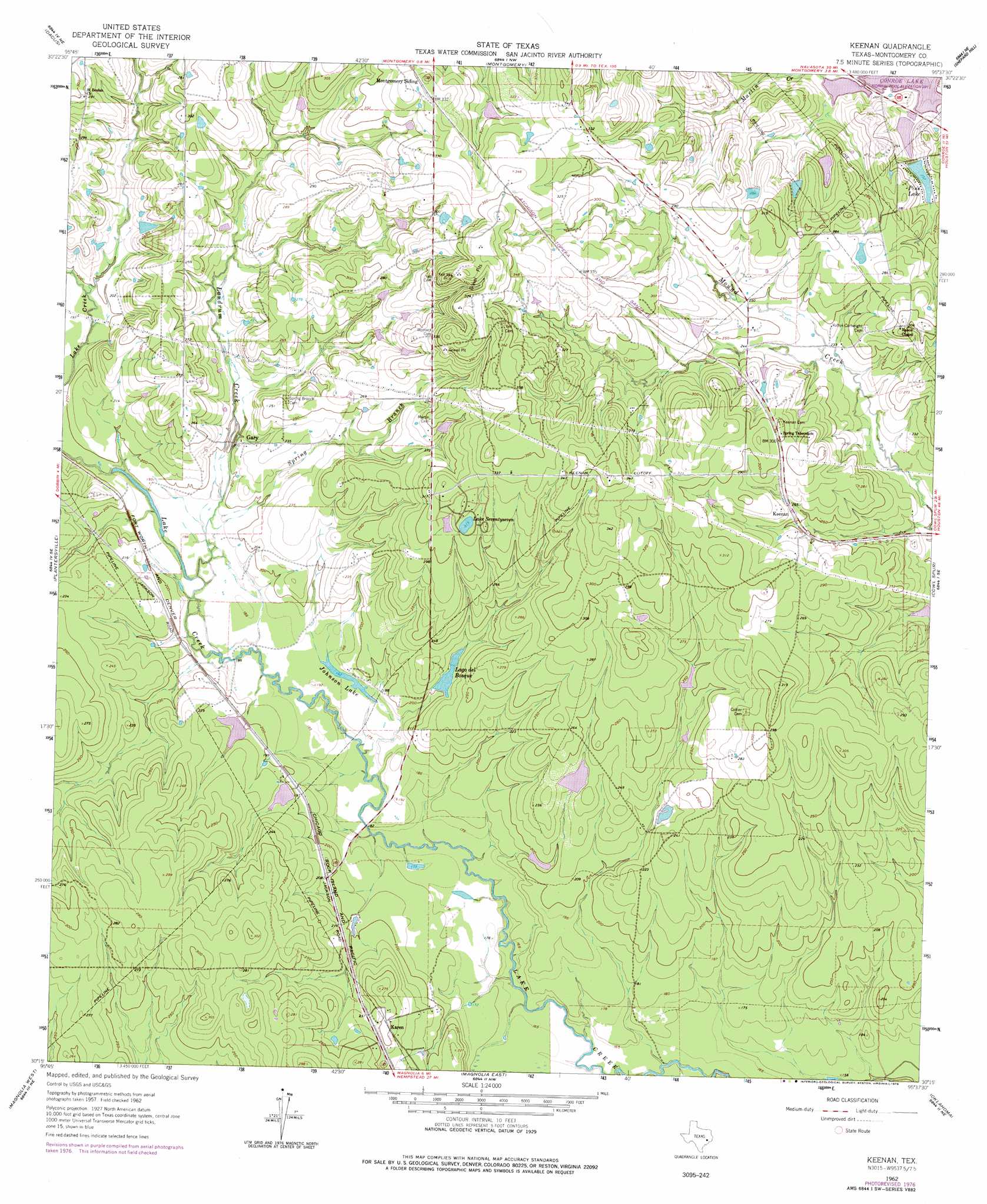
Keenan Topo Map Texas
To zoom in, hover over the map of Keenan
USGS Topo Quad 30095c6 - 1:24,000 scale
| Topo Map Name: | Keenan |
| USGS Topo Quad ID: | 30095c6 |
| Print Size: | ca. 21 1/4" wide x 27" high |
| Southeast Coordinates: | 30.25° N latitude / 95.625° W longitude |
| Map Center Coordinates: | 30.3125° N latitude / 95.6875° W longitude |
| U.S. State: | TX |
| Filename: | o30095c6.jpg |
| Download Map JPG Image: | Keenan topo map 1:24,000 scale |
| Map Type: | Topographic |
| Topo Series: | 7.5´ |
| Map Scale: | 1:24,000 |
| Source of Map Images: | United States Geological Survey (USGS) |
| Alternate Map Versions: |
Keenan TX 1962, updated 1963 Download PDF Buy paper map Keenan TX 1962, updated 1971 Download PDF Buy paper map Keenan TX 1962, updated 1978 Download PDF Buy paper map Keenan TX 2010 Download PDF Buy paper map Keenan TX 2013 Download PDF Buy paper map Keenan TX 2016 Download PDF Buy paper map |
1:24,000 Topo Quads surrounding Keenan
Roans Prairie |
Richards |
San Jacinto |
Moore Grove |
New Waverly |
Anderson |
Dacus |
Montgomery |
Shepard Hill |
Willis |
Stoneham |
Plantersville |
Keenan |
Cowl Spur |
Conroe |
Waller Nw |
Magnolia West |
Magnolia East |
Oklahoma |
Tamina |
Waller |
Hockley |
Rose Hill |
Tomball |
Spring |
> Back to 30095a1 at 1:100,000 scale
> Back to 30094a1 at 1:250,000 scale
> Back to U.S. Topo Maps home
Keenan topo map: Gazetteer
Keenan: Dams
Deer Lake Dam elevation 62m 203′Kim Lake Dam elevation 62m 203′
Lago Del Bosque-Lower Lake Dam elevation 71m 232′
Lago Del Bosque-Upper Lake Dam elevation 65m 213′
Lake Lorraine Dam elevation 62m 203′
Mitchell Lake Dam elevation 64m 209′
Near Kim Lake Dam elevation 62m 203′
Old Lake 177 Dam elevation 95m 311′
Pine Lake Dam elevation 73m 239′
Tri Lake Number 1 Dam elevation 68m 223′
Keenan: Lakes
Johnson Lake elevation 55m 180′Lake Seventyseven elevation 96m 314′
Keenan: Populated Places
Gary elevation 65m 213′Karen elevation 76m 249′
Keenan elevation 82m 269′
Keenan: Reservoirs
Deer Lake elevation 62m 203′Kim Lake elevation 62m 203′
Lago del Bosque elevation 63m 206′
Lago Del Bosque-Lower Lake elevation 71m 232′
Lago Del Bosque-Upper Lake elevation 65m 213′
Lake Lorraine elevation 62m 203′
Mitchell Lake elevation 64m 209′
Near Kim Lake elevation 62m 203′
Old Lake 177 elevation 95m 311′
Pine Lake elevation 67m 219′
Tri Lake Number 1 elevation 68m 223′
Keenan: Streams
Landrum Creek elevation 55m 180′Spring Branch elevation 57m 187′
Keenan digital topo map on disk
Buy this Keenan topo map showing relief, roads, GPS coordinates and other geographical features, as a high-resolution digital map file on DVD: