Shepard Hill Topo Map Texas
To zoom in, hover over the map of Shepard Hill
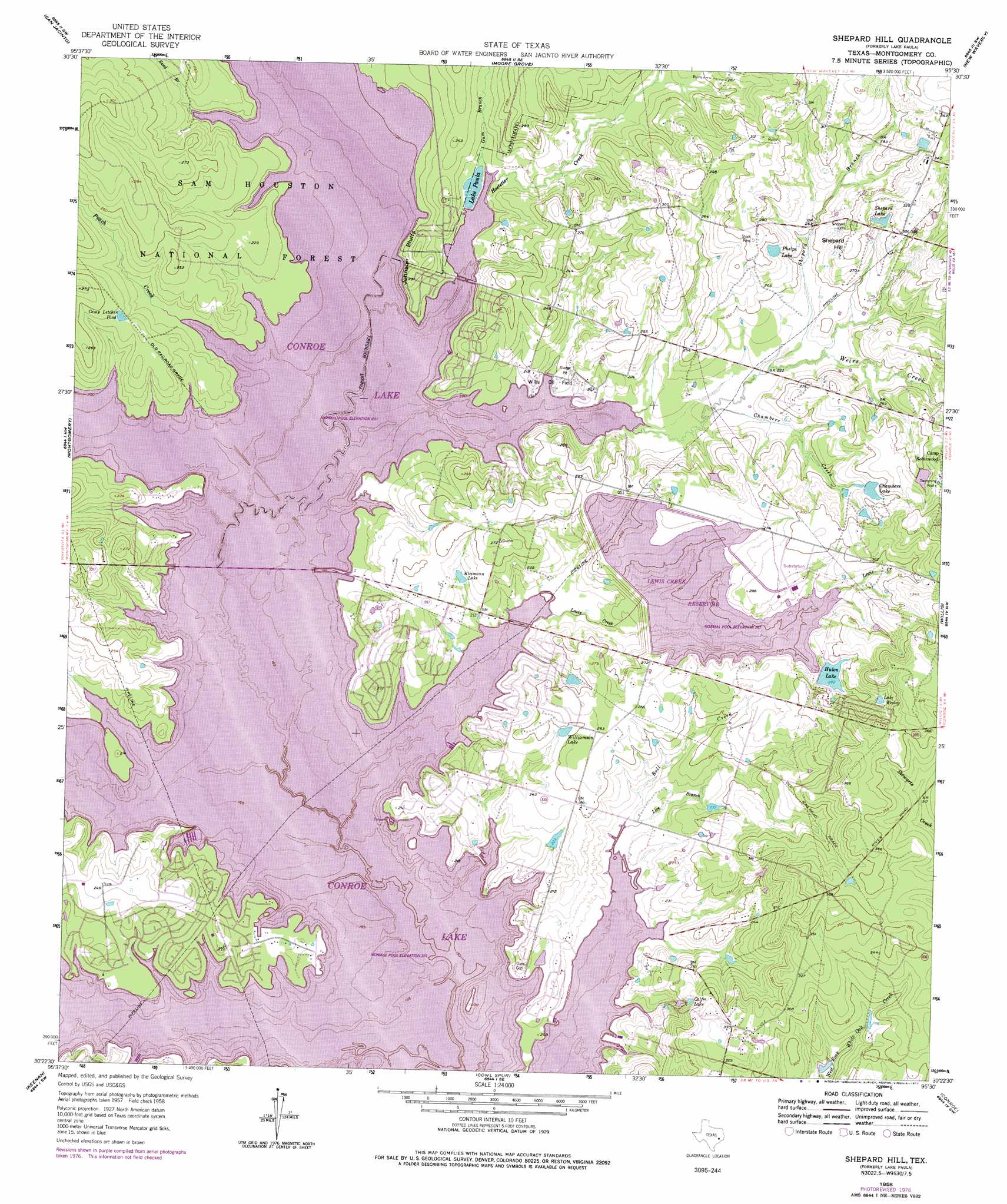
USGS Topo Quad 30095d5 - 1:24,000 scale
| Topo Map Name: | Shepard Hill |
| USGS Topo Quad ID: | 30095d5 |
| Print Size: | ca. 21 1/4" wide x 27" high |
| Southeast Coordinates: | 30.375° N latitude / 95.5° W longitude |
| Map Center Coordinates: | 30.4375° N latitude / 95.5625° W longitude |
| U.S. State: | TX |
| Filename: | o30095d5.jpg |
| Download Map JPG Image: | Shepard Hill topo map 1:24,000 scale |
| Map Type: | Topographic |
| Topo Series: | 7.5´ |
| Map Scale: | 1:24,000 |
| Source of Map Images: | United States Geological Survey (USGS) |
| Alternate Map Versions: |
Lake Paula TX 1958, updated 1959 Download PDF Buy paper map Lake Paula TX 1958, updated 1972 Download PDF Buy paper map Shepard Hill TX 1958, updated 1977 Download PDF Buy paper map Shepard Hill TX 1997, updated 2000 Download PDF Buy paper map Shepard Hill TX 2010 Download PDF Buy paper map Shepard Hill TX 2013 Download PDF Buy paper map Shepard Hill TX 2016 Download PDF Buy paper map |
| FStopo: | US Forest Service topo Shepard Hill is available: Download FStopo PDF Download FStopo TIF |
1:24,000 Topo Quads surrounding Shepard Hill
Loma |
Galilee |
Huntsville |
Phelps |
Oakhurst |
Richards |
San Jacinto |
Moore Grove |
New Waverly |
Maynard |
Dacus |
Montgomery |
Shepard Hill |
Willis |
Conroe Ne |
Plantersville |
Keenan |
Cowl Spur |
Conroe |
Cut And Shoot |
Magnolia West |
Magnolia East |
Oklahoma |
Tamina |
Outlaw Pond |
> Back to 30095a1 at 1:100,000 scale
> Back to 30094a1 at 1:250,000 scale
> Back to U.S. Topo Maps home
Shepard Hill topo map: Gazetteer
Shepard Hill: Airports
Gdap Air Ranch elevation 92m 301′Glenview Number 1 Heliport elevation 63m 206′
Sartor Heliport elevation 62m 203′
Shepard Hill: Cliffs
Johnson Bluff elevation 68m 223′Shepard Hill: Dams
Chambers Lake Dam elevation 84m 275′Hulon Lake Dam elevation 86m 282′
Lake Ann Dam elevation 93m 305′
Lewis Creek Dam elevation 65m 213′
Shepard Hill: Lakes
Calfee Lake elevation 81m 265′Camp Letcher Pond elevation 72m 236′
Kleimann Lake elevation 66m 216′
Lake Wesley elevation 96m 314′
Phelps Lake elevation 87m 285′
Williamson Lake elevation 75m 246′
Shepard Hill: Oilfields
Willis Oil Field elevation 64m 209′Shepard Hill: Reservoirs
Chambers Lake elevation 90m 295′Hulon Lake elevation 86m 282′
Lake Ann elevation 93m 305′
Lake Paula elevation 61m 200′
Lewis Creek Reservoir elevation 81m 265′
Shepard Lake elevation 90m 295′
Shepard Hill: Streams
Atkins Creek elevation 61m 200′Bell Creek elevation 62m 203′
Chambers Creek elevation 64m 209′
Gum Branch elevation 65m 213′
Gum Branch elevation 61m 200′
Hostetter Creek elevation 61m 200′
Lewis Creek elevation 62m 203′
Live Branch elevation 62m 203′
Peach Creek elevation 61m 200′
Peach Creek elevation 61m 200′
Sand Branch elevation 63m 206′
Shepard Branch elevation 62m 203′
South Branch elevation 61m 200′
Weirs Creek elevation 67m 219′
Weirs Creek elevation 62m 203′
Shepard Hill: Summits
Shepard Hill elevation 95m 311′Shepard Hill: Valleys
Pin Oak Ravine elevation 61m 200′Pine Oak Ravine elevation 67m 219′
Shepard Hill digital topo map on disk
Buy this Shepard Hill topo map showing relief, roads, GPS coordinates and other geographical features, as a high-resolution digital map file on DVD: