Whitworth Ranch Topo Map Texas
To zoom in, hover over the map of Whitworth Ranch
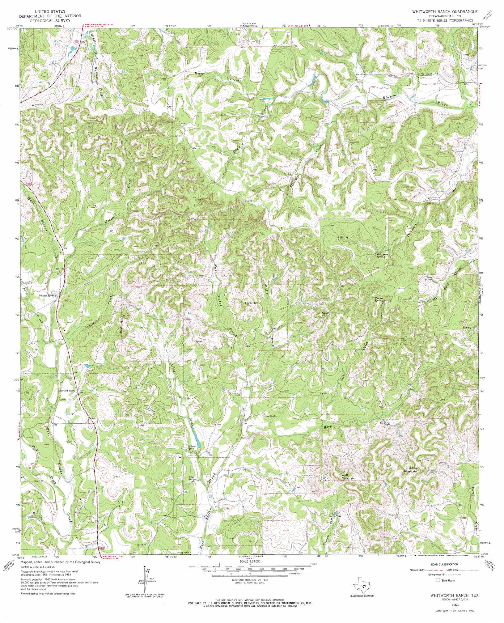
USGS Topo Quad 30098a6 - 1:24,000 scale
| Topo Map Name: | Whitworth Ranch |
| USGS Topo Quad ID: | 30098a6 |
| Print Size: | ca. 21 1/4" wide x 27" high |
| Southeast Coordinates: | 30° N latitude / 98.625° W longitude |
| Map Center Coordinates: | 30.0625° N latitude / 98.6875° W longitude |
| U.S. State: | TX |
| Filename: | o30098a6.jpg |
| Download Map JPG Image: | Whitworth Ranch topo map 1:24,000 scale |
| Map Type: | Topographic |
| Topo Series: | 7.5´ |
| Map Scale: | 1:24,000 |
| Source of Map Images: | United States Geological Survey (USGS) |
| Alternate Map Versions: |
Whitworth Ranch TX 1963, updated 1965 Download PDF Buy paper map Whitworth Ranch TX 2010 Download PDF Buy paper map Whitworth Ranch TX 2012 Download PDF Buy paper map Whitworth Ranch TX 2016 Download PDF Buy paper map |
1:24,000 Topo Quads surrounding Whitworth Ranch
Fredericksburg West |
Fredericksburg East |
Cave Creek School |
Rocky Creek |
Johnson City |
Oak Crest Park |
Cain City |
Stonewall |
Hye |
Monument Hill |
Cypress Creek |
Rafter Hollow |
Whitworth Ranch |
Crabapple Creek |
Blanco |
Comfort |
Waring |
Sisterdale |
Kendalia |
Spring Branch |
Turkey Knob |
Ranger Creek |
Boerne |
Bergheim |
Anhalt |
> Back to 30098a1 at 1:100,000 scale
> Back to 30098a1 at 1:250,000 scale
> Back to U.S. Topo Maps home
Whitworth Ranch topo map: Gazetteer
Whitworth Ranch: Airports
Hunt Ranch Airport elevation 483m 1584′Whitworth Ranch: Parks
Sisterdale Valley District elevation 429m 1407′Whitworth Ranch: Populated Places
Lindendale elevation 526m 1725′Whitworth Ranch: Springs
Carson Spring elevation 565m 1853′Delaware Spring elevation 548m 1797′
Wenzel Spring elevation 442m 1450′
Whitworth Ranch: Streams
Askey Creek elevation 408m 1338′Blackberry Creek elevation 517m 1696′
Haag Creek elevation 419m 1374′
Jung Creek elevation 432m 1417′
Meier Creek elevation 537m 1761′
Platte Creek elevation 431m 1414′
Reeh Creek elevation 406m 1332′
Soell Creek elevation 445m 1459′
Wenzel Creek elevation 450m 1476′
Willie Creek elevation 433m 1420′
Whitworth Ranch: Summits
Bust Buttes elevation 565m 1853′Cave Hill elevation 566m 1856′
Lone Hill elevation 555m 1820′
Meta Mountain elevation 579m 1899′
Wolf Mountain elevation 571m 1873′
Whitworth Ranch digital topo map on disk
Buy this Whitworth Ranch topo map showing relief, roads, GPS coordinates and other geographical features, as a high-resolution digital map file on DVD: