Anhalt Topo Map Texas
To zoom in, hover over the map of Anhalt
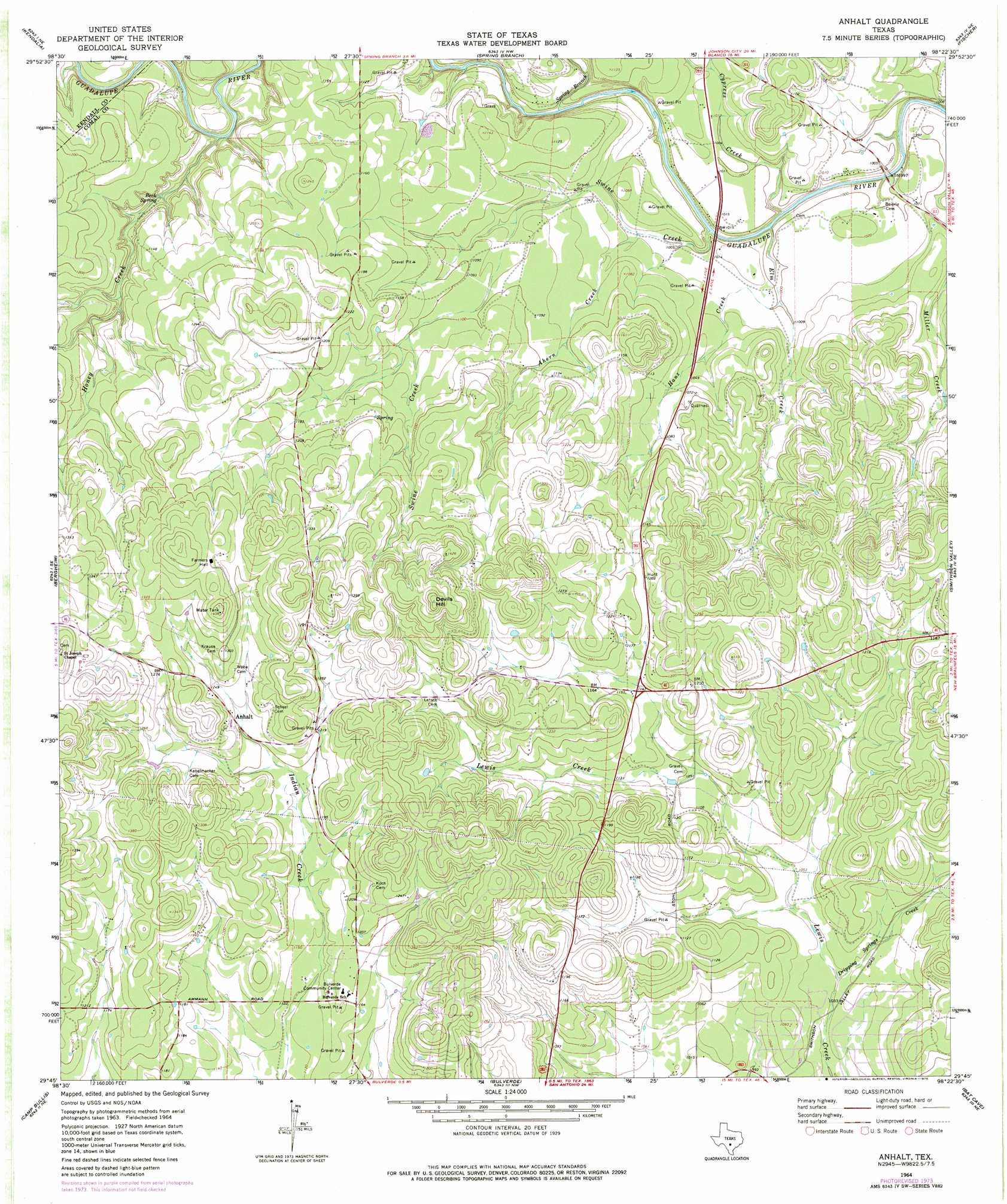
USGS Topo Quad 29098g4 - 1:24,000 scale
| Topo Map Name: | Anhalt |
| USGS Topo Quad ID: | 29098g4 |
| Print Size: | ca. 21 1/4" wide x 27" high |
| Southeast Coordinates: | 29.75° N latitude / 98.375° W longitude |
| Map Center Coordinates: | 29.8125° N latitude / 98.4375° W longitude |
| U.S. State: | TX |
| Filename: | o29098g4.jpg |
| Download Map JPG Image: | Anhalt topo map 1:24,000 scale |
| Map Type: | Topographic |
| Topo Series: | 7.5´ |
| Map Scale: | 1:24,000 |
| Source of Map Images: | United States Geological Survey (USGS) |
| Alternate Map Versions: |
Anhalt TX 1964, updated 1968 Download PDF Buy paper map Anhalt TX 1964, updated 1975 Download PDF Buy paper map Anhalt TX 1964, updated 1975 Download PDF Buy paper map Anhalt TX 2010 Download PDF Buy paper map Anhalt TX 2013 Download PDF Buy paper map Anhalt TX 2016 Download PDF Buy paper map |
1:24,000 Topo Quads surrounding Anhalt
Whitworth Ranch |
Crabapple Creek |
Blanco |
Payton |
Rough Hollow |
Sisterdale |
Kendalia |
Spring Branch |
Fischer |
Devils Backbone |
Boerne |
Bergheim |
Anhalt |
Smithson Valley |
Sattler |
Van Raub |
Camp Bullis |
Bulverde |
Bat Cave |
New Braunfels West |
Helotes |
Castle Hills |
Longhorn |
Schertz |
Marion |
> Back to 29098e1 at 1:100,000 scale
> Back to 29098a1 at 1:250,000 scale
> Back to U.S. Topo Maps home
Anhalt topo map: Gazetteer
Anhalt: Parks
Honey Creek State Natural Area elevation 358m 1174′Anhalt: Populated Places
Anhalt elevation 372m 1220′Bulverde East (historical) elevation 311m 1020′
Bulverde South (historical) elevation 374m 1227′
Anhalt: Springs
Beek Spring elevation 314m 1030′Anhalt: Streams
Ahern Creek elevation 307m 1007′Cypress Creek elevation 291m 954′
Dripping Springs Creek elevation 310m 1017′
Elm Creek elevation 300m 984′
Hanz Creek elevation 302m 990′
Honey Creek elevation 309m 1013′
Spring Branch elevation 298m 977′
Swine Creek elevation 293m 961′
Anhalt: Summits
Devils Hill elevation 466m 1528′Anhalt: Trails
Guadalupe River State Park Trail elevation 366m 1200′Anhalt digital topo map on disk
Buy this Anhalt topo map showing relief, roads, GPS coordinates and other geographical features, as a high-resolution digital map file on DVD: