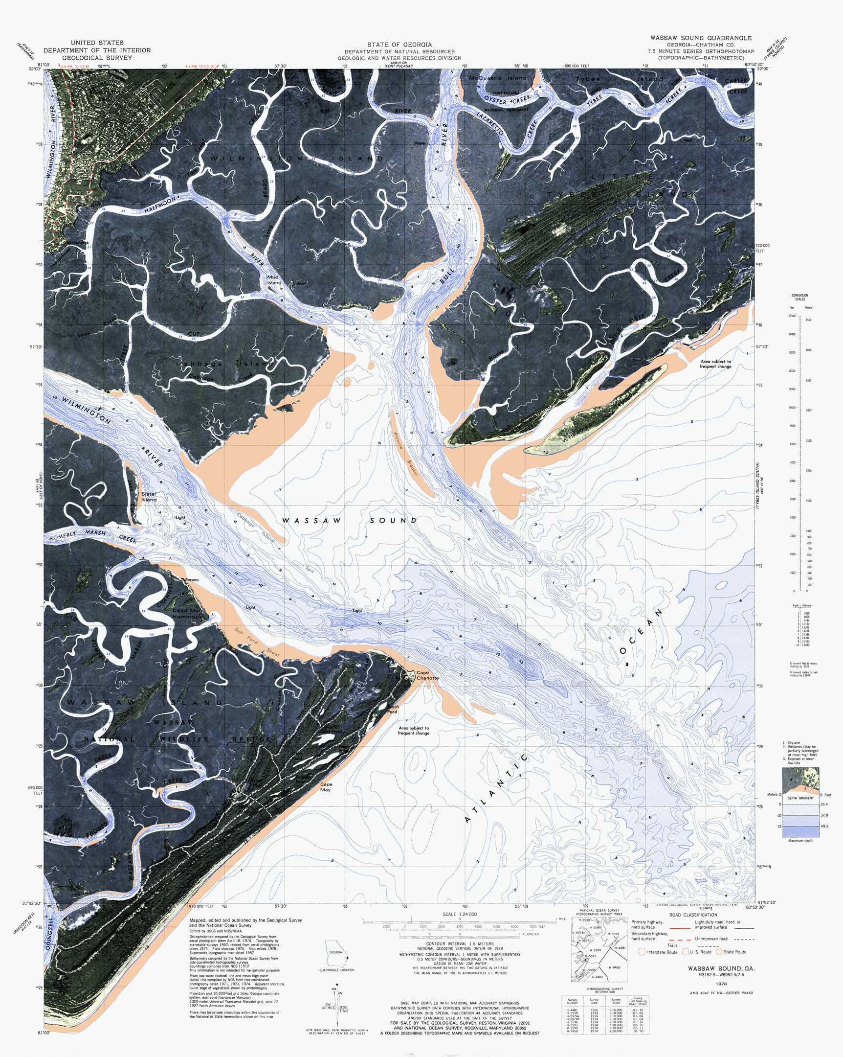
Wassaw Sound Topo Map Georgia
To zoom in, hover over the map of Wassaw Sound
USGS Topo Quad 31080h8 - 1:24,000 scale
| Topo Map Name: | Wassaw Sound |
| USGS Topo Quad ID: | 31080h8 |
| Print Size: | ca. 21 1/4" wide x 27" high |
| Southeast Coordinates: | 31.875° N latitude / 80.875° W longitude |
| Map Center Coordinates: | 31.9375° N latitude / 80.9375° W longitude |
| U.S. State: | GA |
| Filename: | p31080h8.jpg |
| Download Map JPG Image: | Wassaw Sound topo map 1:24,000 scale |
| Map Type: | Orthophoto |
| Topo Series: | 7.5´ |
| Map Scale: | 1:24,000 |
| Source of Map Images: | United States Geological Survey (USGS) |
| Alternate Map Versions: |
Wassaw Sound GA 1957, updated 1959 Download PDF Buy paper map Wassaw Sound GA 1957, updated 1965 Download PDF Buy paper map Wassaw Sound GA 1957, updated 1973 Download PDF Buy paper map Wassaw Sound GA 1978, updated 1978 Download PDF Buy paper map Wassaw Sound GA 2011 Download PDF Buy paper map Wassaw Sound GA 2014 Download PDF Buy paper map |
1:24,000 Topo Quads surrounding Wassaw Sound
Port Wentworth |
Limehouse |
Pritchardville |
Bluffton |
Hilton Head |
Garden City |
Savannah |
Fort Pulaski |
Tybee Island North |
|
Burroughs |
Isle Of Hope |
Wassaw Sound |
Tybee Island South |
|
Oak Level |
Raccoon Key |
|||
Saint Catherines Sound |
> Back to 31080e1 at 1:100,000 scale
> Back to 31080a1 at 1:250,000 scale
> Back to U.S. Topo Maps home
Wassaw Sound topo map: Gazetteer
Wassaw Sound: Bars
Cabbage Island Spit elevation 0m 0′Salt Pond Shoal elevation 0m 0′
Wassaw Breaker elevation 0m 0′
Wassaw Sound: Bays
Wassaw Sound elevation 0m 0′Wassaw Sound: Capes
Cape Charlotte elevation 0m 0′Cape May elevation 0m 0′
Wassaw Sound: Channels
Joes Cut elevation 0m 0′Little Tybee Creek elevation 0m 0′
New Cut elevation 0m 0′
Rhodes Creek elevation 0m 0′
Tybee Cut elevation 0m 0′
Wassaw Sound: Islands
Beach Hammock elevation 0m 0′Cabbage Island elevation 1m 3′
Dead Man Hammock elevation 0m 0′
Little Tybee Island elevation 0m 0′
Long Island elevation 1m 3′
Mud Island elevation 0m 0′
Sister Island elevation 0m 0′
Wassaw Island elevation 1m 3′
Williamson Island elevation 0m 0′
Wassaw Sound: Lakes
Beach Pond elevation 0m 0′Flag Pond elevation 0m 0′
North Otter Pond elevation 1m 3′
Otter Pond elevation 1m 3′
Palmetto Pond elevation 1m 3′
South Pond elevation 2m 6′
Teal Pond elevation 2m 6′
Usher Pond elevation 1m 3′
Wassaw Sound: Parks
National Wassaw Wildlife Refuge elevation 0m 0′Wassaw Sound: Populated Places
Wilmington elevation 4m 13′Wilmington Park elevation 3m 9′
Wassaw Sound: Streams
Beard Creek elevation 0m 0′Blue Bank Creek elevation 0m 0′
Bull River elevation 0m 0′
Cabbage Creek elevation 0m 0′
Carter Creek elevation 0m 0′
Crooked Creek elevation 0m 0′
Halfmoon River elevation 0m 0′
House Creek elevation 0m 0′
Long Creek elevation 0m 0′
Mill Creek elevation 0m 0′
Old Romerly Marsh Channel elevation 0m 0′
Oyster Creek elevation 0m 0′
Romerly Marsh Creek elevation 0m 0′
Seine Creek elevation 0m 0′
Sheepshead Creek elevation 0m 0′
Tom Creek elevation 0m 0′
Wilmington River elevation 0m 0′
Wassaw Sound digital topo map on disk
Buy this Wassaw Sound topo map showing relief, roads, GPS coordinates and other geographical features, as a high-resolution digital map file on DVD: