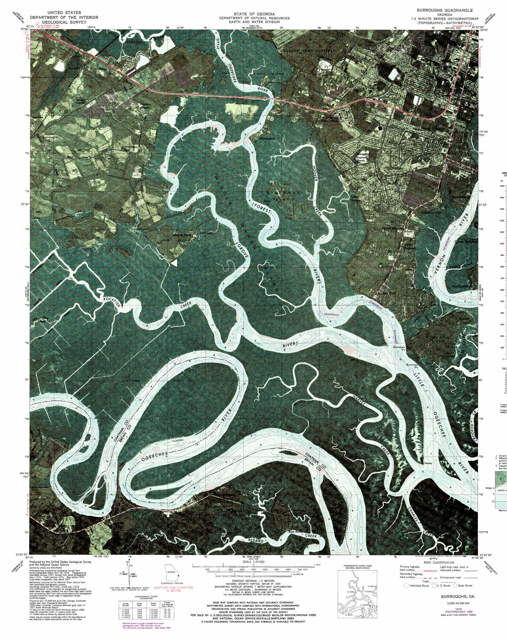
Burroughs Topo Map Georgia
To zoom in, hover over the map of Burroughs
USGS Topo Quad 31081h2 - 1:24,000 scale
| Topo Map Name: | Burroughs |
| USGS Topo Quad ID: | 31081h2 |
| Print Size: | ca. 21 1/4" wide x 27" high |
| Southeast Coordinates: | 31.875° N latitude / 81.125° W longitude |
| Map Center Coordinates: | 31.9375° N latitude / 81.1875° W longitude |
| U.S. State: | GA |
| Filename: | p31081h2.jpg |
| Download Map JPG Image: | Burroughs topo map 1:24,000 scale |
| Map Type: | Orthophoto |
| Topo Series: | 7.5´ |
| Map Scale: | 1:24,000 |
| Source of Map Images: | United States Geological Survey (USGS) |
| Alternate Map Versions: |
Burroughs GA 1957, updated 1959 Download PDF Buy paper map Burroughs GA 1957, updated 1964 Download PDF Buy paper map Burroughs GA 1957, updated 1973 Download PDF Buy paper map Burroughs GA 1979, updated 1979 Download PDF Buy paper map Burroughs GA 1979, updated 1987 Download PDF Buy paper map Burroughs GA 1979, updated 1988 Download PDF Buy paper map Burroughs GA 2011 Download PDF Buy paper map Burroughs GA 2014 Download PDF Buy paper map |
1:24,000 Topo Quads surrounding Burroughs
Eden |
Meldrim |
Port Wentworth |
Limehouse |
Pritchardville |
Meldrim Sw |
Meldrim Se |
Garden City |
Savannah |
Fort Pulaski |
Limerick Nw |
Richmond Hill |
Burroughs |
Isle Of Hope |
Wassaw Sound |
Dorchester |
Limerick Se |
Oak Level |
Raccoon Key |
|
Riceboro |
Seabrook |
Saint Catherines Sound |
> Back to 31081e1 at 1:100,000 scale
> Back to 31080a1 at 1:250,000 scale
> Back to U.S. Topo Maps home
Burroughs topo map: Gazetteer
Burroughs: Airports
Hodges Airpark elevation 2m 6′Saint Josephs Hospital Heliport elevation 9m 29′
Burroughs: Canals
New Hope Canal elevation 1m 3′Red Dock Canal elevation 1m 3′
Southfield Canal elevation 1m 3′
Walker Canal elevation 1m 3′
Burroughs: Capes
Genesis Point elevation 4m 13′Palmetto Point elevation 1m 3′
Sunrise Point elevation 0m 0′
Burroughs: Channels
Harvey Cut elevation 1m 3′Burroughs: Islands
Fort Hammock elevation 1m 3′Harveys Island elevation 1m 3′
Lotts Island elevation 1m 3′
Middle Marsh Island elevation 1m 3′
Pine Hammock elevation 1m 3′
Rose Dhu Island elevation 4m 13′
Savage Island elevation 3m 9′
Shed Island elevation 1m 3′
Steadman Island elevation 1m 3′
Burroughs: Parks
Richmond Hill State Park elevation 3m 9′Burroughs: Populated Places
Berkshire Woods elevation 6m 19′Burroughs elevation 4m 13′
Cedar Grove elevation 6m 19′
Coffee Bluff elevation 5m 16′
Coffee Bluff Plantation elevation 7m 22′
Colonial Oaks elevation 4m 13′
Dyches Mobile Home Park elevation 12m 39′
Forest River Farms elevation 3m 9′
Fort McAllister elevation 4m 13′
Georgetown elevation 4m 13′
Grove Point elevation 2m 6′
Grove Point Mobile Home Estates elevation 3m 9′
Leedsgate elevation 5m 16′
Mount Herman elevation 2m 6′
Mount Pleasant elevation 5m 16′
Myrtle Grove elevation 3m 9′
Nicholsonville elevation 5m 16′
Southside Mobile Estates elevation 12m 39′
Tranquilla Woods elevation 7m 22′
Village Green elevation 3m 9′
Welwood elevation 6m 19′
White Bluff elevation 8m 26′
Williamsburg Manor elevation 9m 29′
Wilshire elevation 6m 19′
Windsor Forest elevation 6m 19′
Windsor on the Marsh elevation 5m 16′
Windward elevation 1m 3′
Burroughs: Post Offices
Southside Post Office elevation 5m 16′Burroughs: Streams
Forest River elevation 0m 0′Friday Creek elevation 1m 3′
Grove River elevation 0m 0′
Harvey Creek elevation 0m 0′
Hoover Creek elevation 0m 0′
Houston Creek elevation 0m 0′
Rockfish Creek elevation 0m 0′
Burroughs digital topo map on disk
Buy this Burroughs topo map showing relief, roads, GPS coordinates and other geographical features, as a high-resolution digital map file on DVD: