Queensland Topo Map Georgia
To zoom in, hover over the map of Queensland
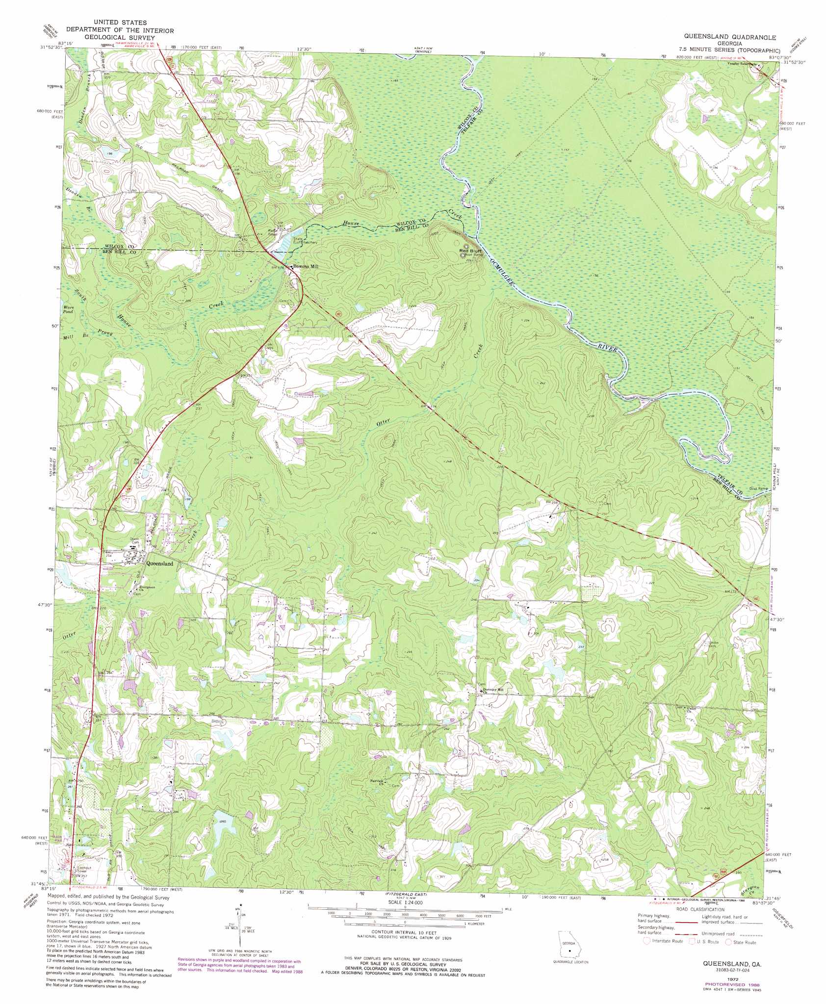
USGS Topo Quad 31083g2 - 1:24,000 scale
| Topo Map Name: | Queensland |
| USGS Topo Quad ID: | 31083g2 |
| Print Size: | ca. 21 1/4" wide x 27" high |
| Southeast Coordinates: | 31.75° N latitude / 83.125° W longitude |
| Map Center Coordinates: | 31.8125° N latitude / 83.1875° W longitude |
| U.S. State: | GA |
| Filename: | o31083g2.jpg |
| Download Map JPG Image: | Queensland topo map 1:24,000 scale |
| Map Type: | Topographic |
| Topo Series: | 7.5´ |
| Map Scale: | 1:24,000 |
| Source of Map Images: | United States Geological Survey (USGS) |
| Alternate Map Versions: |
Queensland GA 1972, updated 1988 Download PDF Buy paper map Queensland GA 1977, updated 1977 Download PDF Buy paper map Queensland GA 2011 Download PDF Buy paper map Queensland GA 2014 Download PDF Buy paper map |
1:24,000 Topo Quads surrounding Queensland
Pineview East |
Abbeville North |
Lake Cypress |
Milan |
Mcrae |
Rochelle |
Abbeville South |
Rhine |
Cooks Still |
Workmore |
Rebecca |
Sibbie |
Queensland |
China Hill |
Jacksonville |
Irwinville |
Fitzgerald West |
Fitzgerald East |
Osierfield |
Broxton North |
Waterloo |
Ocilla West |
Ocilla East |
Ambrose |
Broxton South |
> Back to 31083e1 at 1:100,000 scale
> Back to 31082a1 at 1:250,000 scale
> Back to U.S. Topo Maps home
Queensland topo map: Gazetteer
Queensland: Airports
Bowens Mill Christian Center Airport elevation 50m 164′Queensland: Cliffs
Red Bluff elevation 48m 157′Queensland: Dams
N J Wilson Lake Dam elevation 71m 232′Tuggle Lake Dam elevation 79m 259′
W E Tuggle Dam elevation 76m 249′
Wilson Dam elevation 77m 252′
Queensland: Populated Places
Bowens Mill elevation 54m 177′Forest Glen elevation 63m 206′
Lulaville elevation 85m 278′
Queensland elevation 76m 249′
Queensland: Reservoirs
Tuggle Lake elevation 79m 259′W J Wilson Lake elevation 71m 232′
Queensland: Springs
Oscewichee Spring elevation 48m 157′Queensland: Streams
Deaden Branch elevation 54m 177′House Creek elevation 48m 157′
Mill Branch elevation 51m 167′
Otter Creek elevation 48m 157′
South Prong House Creek elevation 51m 167′
Queensland digital topo map on disk
Buy this Queensland topo map showing relief, roads, GPS coordinates and other geographical features, as a high-resolution digital map file on DVD: