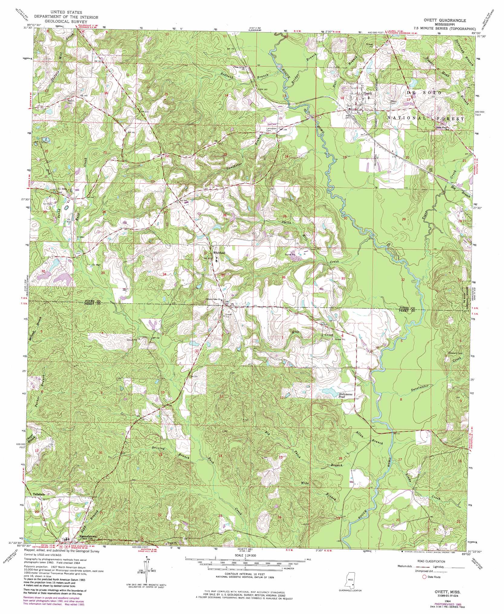
Ovett Topo Map Mississippi
To zoom in, hover over the map of Ovett
USGS Topo Quad 31089d1 - 1:24,000 scale
| Topo Map Name: | Ovett |
| USGS Topo Quad ID: | 31089d1 |
| Print Size: | ca. 21 1/4" wide x 27" high |
| Southeast Coordinates: | 31.375° N latitude / 89° W longitude |
| Map Center Coordinates: | 31.4375° N latitude / 89.0625° W longitude |
| U.S. State: | MS |
| Filename: | o31089d1.jpg |
| Download Map JPG Image: | Ovett topo map 1:24,000 scale |
| Map Type: | Topographic |
| Topo Series: | 7.5´ |
| Map Scale: | 1:24,000 |
| Source of Map Images: | United States Geological Survey (USGS) |
| Alternate Map Versions: |
Ovett MS 1964, updated 1965 Download PDF Buy paper map Ovett MS 1964, updated 1978 Download PDF Buy paper map Ovett MS 1964, updated 1985 Download PDF Buy paper map Ovett MS 2000, updated 2002 Download PDF Buy paper map Ovett MS 2012 Download PDF Buy paper map Ovett MS 2015 Download PDF Buy paper map |
| FStopo: | US Forest Service topo Ovett is available: Download FStopo PDF Download FStopo TIF |
1:24,000 Topo Quads surrounding Ovett
Hebron |
Laurel West |
Laurel East |
Myrick |
Whistler |
Moselle |
Ellisville |
Lanham |
Strengthford |
Water Oak |
Eastabuchie |
Barrontown |
Ovett |
Rhodes |
Mulberry |
Hattiesburg |
Carterville |
Ovett Se |
Richton |
Brewer |
Dixie |
Mclaurin |
New Augusta |
Beaumont |
Neely |
> Back to 31089a1 at 1:100,000 scale
> Back to 31088a1 at 1:250,000 scale
> Back to U.S. Topo Maps home
Ovett topo map: Gazetteer
Ovett: Dams
Carl Hollomans Pond Dam elevation 57m 187′Vickers Lake Dam elevation 78m 255′
Vickers Lake Dam elevation 71m 232′
Vickers Lake Dam elevation 73m 239′
Ovett: Populated Places
Ovett elevation 61m 200′Runnelstown elevation 48m 157′
Tallahala elevation 53m 173′
Whitfield elevation 85m 278′
Ovett: Reservoirs
Hollomans Pond elevation 53m 173′Ovett: Streams
Allan Branch elevation 37m 121′Baylss Branch elevation 45m 147′
Big Thick Branch elevation 36m 118′
Bridge Branch elevation 47m 154′
Driving Branch elevation 51m 167′
Dry Prong elevation 66m 216′
Hall Branch elevation 47m 154′
Hog Branch elevation 47m 154′
Lancaster Branch elevation 49m 160′
Linda Creek elevation 37m 121′
Mike Branch elevation 36m 118′
Mill Creek elevation 39m 127′
Redbank Branch elevation 48m 157′
Smith Mill Creek elevation 42m 137′
Sweetwater Creek elevation 39m 127′
Tiger Creek elevation 41m 134′
Ovett digital topo map on disk
Buy this Ovett topo map showing relief, roads, GPS coordinates and other geographical features, as a high-resolution digital map file on DVD:
Gulf Coast (LA, MS, AL, FL) & Southwestern Georgia
Buy digital topo maps: Gulf Coast (LA, MS, AL, FL) & Southwestern Georgia
 & Southwestern Georgia map DVD")