Temple Topo Map Louisiana
To zoom in, hover over the map of Temple
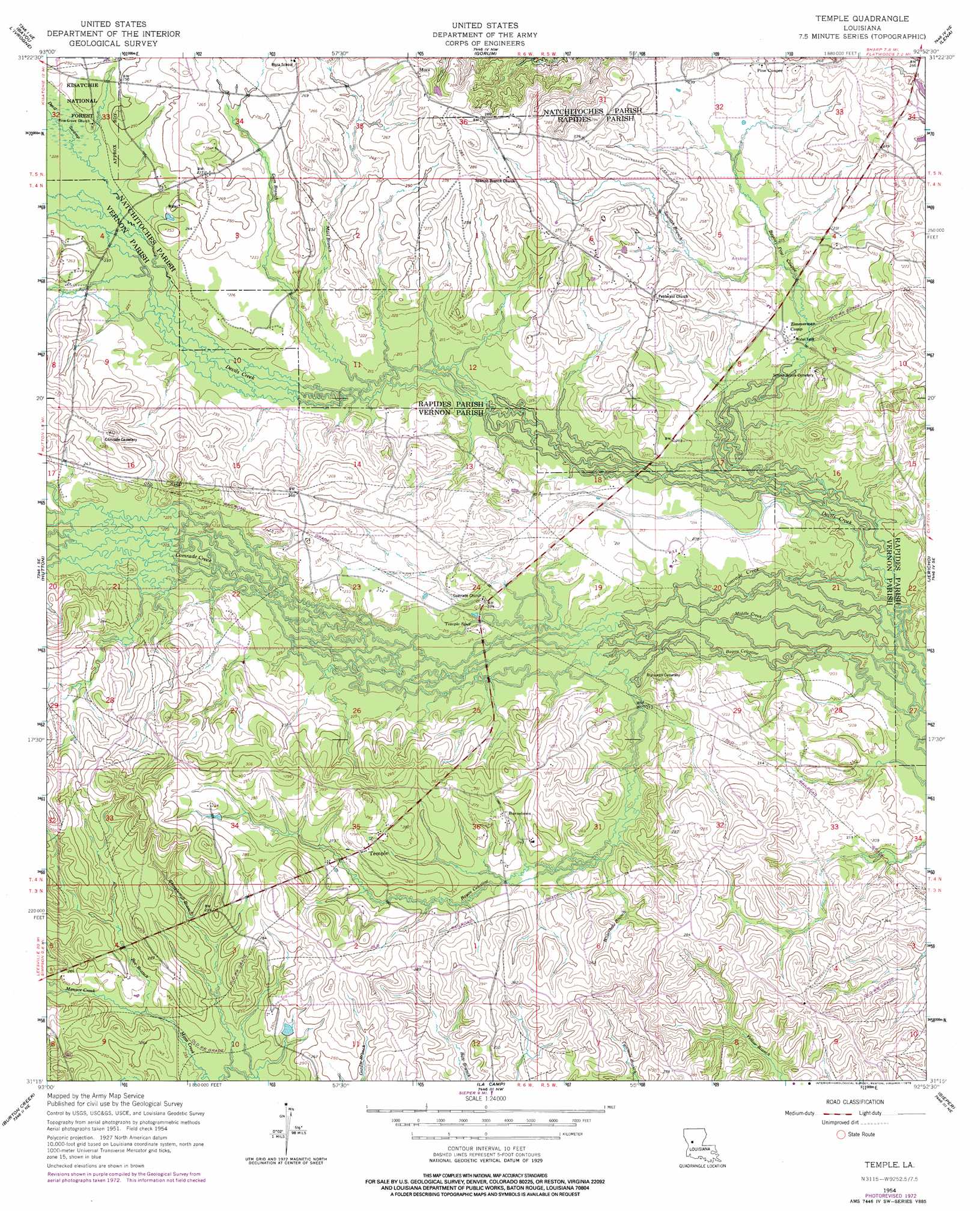
USGS Topo Quad 31092c8 - 1:24,000 scale
| Topo Map Name: | Temple |
| USGS Topo Quad ID: | 31092c8 |
| Print Size: | ca. 21 1/4" wide x 27" high |
| Southeast Coordinates: | 31.25° N latitude / 92.875° W longitude |
| Map Center Coordinates: | 31.3125° N latitude / 92.9375° W longitude |
| U.S. State: | LA |
| Filename: | o31092c8.jpg |
| Download Map JPG Image: | Temple topo map 1:24,000 scale |
| Map Type: | Topographic |
| Topo Series: | 7.5´ |
| Map Scale: | 1:24,000 |
| Source of Map Images: | United States Geological Survey (USGS) |
| Alternate Map Versions: |
Temple LA 1954, updated 1959 Download PDF Buy paper map Temple LA 1954, updated 1976 Download PDF Buy paper map Temple LA 2003, updated 2005 Download PDF Buy paper map Temple LA 2012 Download PDF Buy paper map Temple LA 2015 Download PDF Buy paper map |
| FStopo: | US Forest Service topo Temple is available: Download FStopo PDF Download FStopo TIF |
1:24,000 Topo Quads surrounding Temple
Bellwood |
Natchitoches South |
Cloutierville |
Aloha |
Colfax |
Kisatchie |
Bayou Livrogne |
Gorum |
Lena |
Boyce |
Kurthwood |
Simpson North |
Temple |
Jericho |
Gardner |
Slagle |
Simpson South |
Lacamp |
Sieper |
Elmer |
Fort Polk |
Birds Creek |
Fullerton Lake |
Afeman |
Melder |
> Back to 31092a1 at 1:100,000 scale
> Back to 31092a1 at 1:250,000 scale
> Back to U.S. Topo Maps home
Temple topo map: Gazetteer
Temple: Populated Places
Burnstown elevation 80m 262′Comrade elevation 78m 255′
Hood elevation 65m 213′
Jacksonville (historical) elevation 74m 242′
Mora elevation 88m 288′
Pine Coupee elevation 75m 246′
Temple elevation 86m 282′
Temple: Post Offices
Mora Post Office elevation 87m 285′Temple: Streams
Bayou Celestine elevation 60m 196′Bayou Celestine elevation 60m 196′
Bayou Pine Coupee elevation 61m 200′
Bee Branch elevation 70m 229′
Cypress Branch elevation 68m 223′
Devils Creek elevation 59m 193′
Gum Branch elevation 65m 213′
Marl Branch elevation 66m 216′
Menace Creek elevation 70m 229′
Middle Creek elevation 59m 193′
Shinglemill Branch elevation 68m 223′
Spanish Branch elevation 65m 213′
Spring Branch elevation 68m 223′
Waterhole Branch elevation 67m 219′
Temple digital topo map on disk
Buy this Temple topo map showing relief, roads, GPS coordinates and other geographical features, as a high-resolution digital map file on DVD: