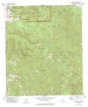
Rustler Park Topo Map Arizona
To zoom in, hover over the map of Rustler Park
USGS Topo Quad 31109h3 - 1:24,000 scale
| Topo Map Name: | Rustler Park |
| USGS Topo Quad ID: | 31109h3 |
| Print Size: | ca. 21 1/4" wide x 27" high |
| Southeast Coordinates: | 31.875° N latitude / 109.25° W longitude |
| Map Center Coordinates: | 31.9375° N latitude / 109.3125° W longitude |
| U.S. State: | AZ |
| Filename: | o31109h3.jpg |
| Download Map JPG Image: | Rustler Park topo map 1:24,000 scale |
| Map Type: | Topographic |
| Topo Series: | 7.5´ |
| Map Scale: | 1:24,000 |
| Source of Map Images: | United States Geological Survey (USGS) |
| Alternate Map Versions: |
Rustler Park AZ 1978, updated 1978 Download PDF Buy paper map Rustler Park AZ 1978, updated 1978 Download PDF Buy paper map Rustler Park AZ 2012 Download PDF Buy paper map Rustler Park AZ 2014 Download PDF Buy paper map |
| FStopo: | US Forest Service topo Rustler Park is available: Download FStopo PDF Download FStopo TIF |
1:24,000 Topo Quads surrounding Rustler Park
> Back to 31109e1 at 1:100,000 scale
> Back to 31108a1 at 1:250,000 scale
> Back to U.S. Topo Maps home
Rustler Park topo map: Gazetteer
Rustler Park: Cliffs
Centella Point elevation 2809m 9215′Rustler Park: Flats
Barfoot Park elevation 2490m 8169′Flys Park elevation 2733m 8966′
Long Park elevation 2746m 9009′
Rustler Park elevation 0m 0′
Turkey Park elevation 2307m 7568′
Rustler Park: Gaps
Bootlegger Saddle elevation 2707m 8881′Downing Pass elevation 1937m 6354′
Fife Saddle elevation 1967m 6453′
Hands Pass elevation 2045m 6709′
Jhus Horse Saddle elevation 2148m 7047′
Onion Saddle elevation 2322m 7618′
Rattle Rock Saddle elevation 2331m 7647′
Saulsbury Saddle elevation 0m 0′
Rustler Park: Mines
Blacksmith Tunnel elevation 2112m 6929′El Tigre Mine elevation 2132m 6994′
Grey Tunnel elevation 1874m 6148′
Hilltop Mine elevation 1936m 6351′
Lead Lily Shaft elevation 2010m 6594′
Rhem Tunnel elevation 1780m 5839′
Rieder Tunnel elevation 1746m 5728′
Silver Prince Mine elevation 0m 0′
Rustler Park: Populated Places
Hilltop elevation 1738m 5702′Rustler Park: Reservoirs
Hughes Tank elevation 1841m 6040′MacKey Tank elevation 1977m 6486′
Monkey Tank elevation 1842m 6043′
Rustler Park: Springs
Avispa Spring elevation 1856m 6089′Barfoot Spring elevation 2514m 8248′
Bear Wallow Spring elevation 2122m 6961′
Hillside Spring elevation 2687m 8815′
Ida Peak Spring elevation 2389m 7837′
Iron Spring elevation 2049m 6722′
Lower Rustler Spring elevation 2551m 8369′
Onion Spring elevation 2214m 7263′
Pine Spring elevation 2106m 6909′
Riggs Spring elevation 1697m 5567′
Tub Spring elevation 2781m 9124′
Upper Rustler Spring elevation 2582m 8471′
Rustler Park: Streams
East Whitetail Creek elevation 1550m 5085′Rustler Park: Summits
Barfoot Peak elevation 2674m 8772′Buena Vista Peak elevation 2668m 8753′
Garfield Peak elevation 1864m 6115′
Ida Peak elevation 2521m 8270′
Rattlesnake Peak elevation 2412m 7913′
Shaw Peak elevation 0m 0′
Rustler Park: Trails
Rock Canyon Trail Two Hundred Fiftynine elevation 1992m 6535′Saulsbury Canyon Trail Two Hundred Sixtythree elevation 2434m 7985′
Shaw Peak Trail Two Hundred Fiftyone elevation 2159m 7083′
Turkey Pen Canyon Trail Two Hundred Sixtytwo elevation 1909m 6263′
Rustler Park: Tunnels
Kasper Tunnel elevation 2109m 6919′Rustler Park: Valleys
Green Canyon elevation 1732m 5682′Hoovey Canyon elevation 1761m 5777′
Horsefall Canyon elevation 1733m 5685′
Hunt Canyon elevation 2055m 6742′
Jesse James Canyon elevation 1660m 5446′
Little Jesse James Canyon elevation 1684m 5524′
MacKey Canyon elevation 1555m 5101′
North Fork Horsefall Canyon elevation 1771m 5810′
Pinery Canyon elevation 1628m 5341′
Rattlesnake Canyon elevation 1975m 6479′
Rustler Park digital topo map on disk
Buy this Rustler Park topo map showing relief, roads, GPS coordinates and other geographical features, as a high-resolution digital map file on DVD:


