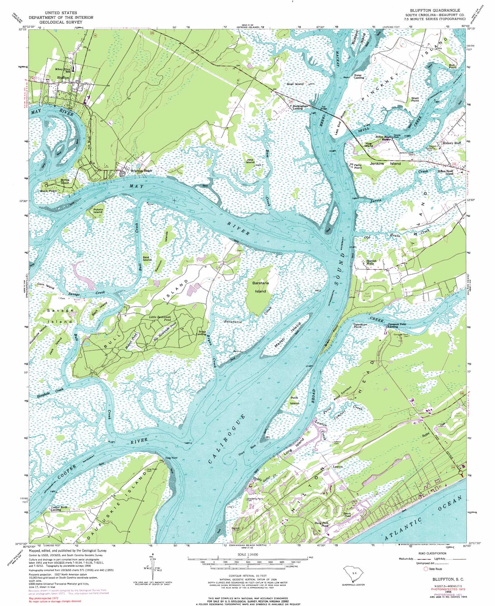
Bluffton Topo Map South Carolina
To zoom in, hover over the map of Bluffton
USGS Topo Quad 32080b7 - 1:24,000 scale
| Topo Map Name: | Bluffton |
| USGS Topo Quad ID: | 32080b7 |
| Print Size: | ca. 21 1/4" wide x 27" high |
| Southeast Coordinates: | 32.125° N latitude / 80.75° W longitude |
| Map Center Coordinates: | 32.1875° N latitude / 80.8125° W longitude |
| U.S. State: | SC |
| Filename: | o32080b7.jpg |
| Download Map JPG Image: | Bluffton topo map 1:24,000 scale |
| Map Type: | Topographic |
| Topo Series: | 7.5´ |
| Map Scale: | 1:24,000 |
| Source of Map Images: | United States Geological Survey (USGS) |
| Alternate Map Versions: |
Bluffton SC 1956, updated 1957 Download PDF Buy paper map Bluffton SC 1956, updated 1969 Download PDF Buy paper map Bluffton SC 1956, updated 1972 Download PDF Buy paper map Bluffton SC 1956, updated 1976 Download PDF Buy paper map Bluffton SC 1956, updated 1984 Download PDF Buy paper map Bluffton SC 2011 Download PDF Buy paper map Bluffton SC 2014 Download PDF Buy paper map |
1:24,000 Topo Quads surrounding Bluffton
Tillman |
Ridgeland |
Laurel Bay |
Beaufort |
Frogmore |
Hardeeville |
Jasper |
Spring Island |
Parris Island |
Saint Phillips Island |
Limehouse |
Pritchardville |
Bluffton |
Hilton Head |
|
Savannah |
Fort Pulaski |
Tybee Island North |
||
Isle Of Hope |
Wassaw Sound |
Tybee Island South |
> Back to 32080a1 at 1:100,000 scale
> Back to 32080a1 at 1:250,000 scale
> Back to U.S. Topo Maps home
Bluffton topo map: Gazetteer
Bluffton: Bars
Calibogue Shoal elevation 0m 0′Shark Bank elevation 0m 0′
Bluffton: Bays
Baynard Cove elevation 0m 0′Bluffton: Bridges
Karl Bowers Bridge elevation 0m 0′Wilton Graves Bridge elevation 0m 0′
Bluffton: Capes
Bram Point elevation 3m 9′Buck Point elevation 3m 9′
Bull Point elevation 3m 9′
Ferry Point elevation 3m 9′
Haig Point elevation 6m 19′
Last End Point elevation 2m 6′
Opossum Point elevation 3m 9′
Point Comfort elevation 3m 9′
Shell Point elevation 3m 9′
Bluffton: Channels
Bull Creek elevation 0m 0′Skull Creek elevation 0m 0′
Bluffton: Cliffs
Kirk Bluff elevation 6m 19′Bluffton: Islands
Back Island elevation 3m 9′Barataria Island elevation 3m 9′
Buck Island elevation 3m 9′
Bull Island elevation 4m 13′
Buzzard Island elevation 3m 9′
Corn Island elevation 3m 9′
Goat Island elevation 3m 9′
Hog Island elevation 3m 9′
Hoophole Island elevation 3m 9′
Jack Island elevation 3m 9′
Jenkins Island elevation 3m 9′
Jess Island elevation 3m 9′
Long Island elevation 3m 9′
Middle Marsh Island elevation 3m 9′
Pinckney Island elevation 3m 9′
Potato Island elevation 3m 9′
Raccoon Islands elevation 3m 9′
Savage Island elevation 3m 9′
Skid Island elevation 3m 9′
Bluffton: Lakes
Beach Pond elevation 3m 9′Buoy Path Pond elevation 2m 6′
Bluffton: Parks
Coligny Circle elevation 3m 9′Sea Pines Forest Preserve elevation 3m 9′
Bluffton: Populated Places
Bay Pines elevation 3m 9′Bluffton elevation 6m 19′
Brighton Beach elevation 3m 9′
Bryan Landing elevation 3m 9′
Buckingham Landing elevation 3m 9′
Calibogue Cay elevation 3m 9′
Cooper River Landing elevation 3m 9′
Fairway Oaks elevation 3m 9′
Greenwood Forest elevation 3m 9′
Harbour Town elevation 3m 9′
Heritage Woods elevation 3m 9′
Hickory Bluff elevation 3m 9′
Hilton Head Island elevation 3m 9′
Horse Landing elevation 3m 9′
Lawton elevation 3m 9′
Myrtle Island elevation 3m 9′
Opossum Point Landing elevation 3m 9′
Point Comfort elevation 3m 9′
Point Comfort Woods elevation 3m 9′
Sea Pines elevation 3m 9′
Sea Pines Circle elevation 3m 9′
Sea Pines Plantation elevation 3m 9′
Spanish Wells elevation 3m 9′
Wexford Plantation elevation 3m 9′
Windmill Harbor elevation 3m 9′
Bluffton: Post Offices
Bluffton Post Office elevation 6m 19′Harbourtown Branch Post Office elevation 3m 9′
Hilton Head Island Post Office elevation 3m 9′
Bluffton: Streams
Barataria Creek elevation 3m 9′Bass Creek elevation 0m 0′
Broad Creek elevation 0m 0′
Bryan Creek elevation 0m 0′
Heddy Gutter Creek elevation 0m 0′
Hoophole Creek elevation 3m 9′
Jarvis Creek elevation 0m 0′
Lawton Creek elevation 0m 0′
Mackay Creek elevation 0m 0′
May River elevation 0m 0′
Moss Creek elevation 0m 0′
Old House Creek elevation 0m 0′
Point Comfort Creek elevation 0m 0′
Savage Creek elevation 0m 0′
Bluffton: Swamps
Big Savannah Pond elevation 4m 13′Hubert Pond elevation 5m 16′
Little Savannah Pond elevation 3m 9′
White Ibis Pond elevation 3m 9′
Bluffton digital topo map on disk
Buy this Bluffton topo map showing relief, roads, GPS coordinates and other geographical features, as a high-resolution digital map file on DVD:
South Carolina, Western North Carolina & Northeastern Georgia
Buy digital topo maps: South Carolina, Western North Carolina & Northeastern Georgia