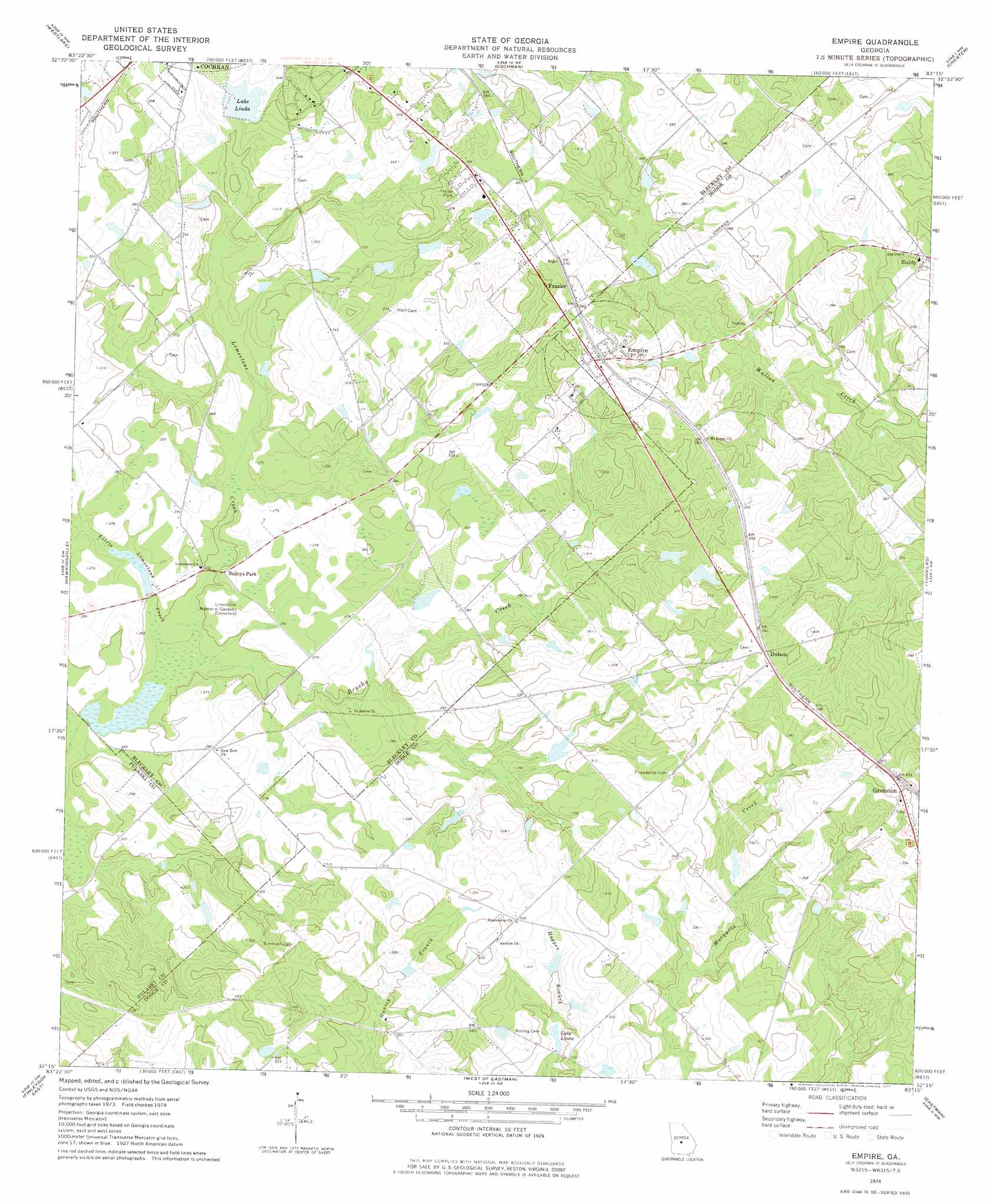
Empire Topo Map Georgia
To zoom in, hover over the map of Empire
USGS Topo Quad 32083c3 - 1:24,000 scale
| Topo Map Name: | Empire |
| USGS Topo Quad ID: | 32083c3 |
| Print Size: | ca. 21 1/4" wide x 27" high |
| Southeast Coordinates: | 32.25° N latitude / 83.25° W longitude |
| Map Center Coordinates: | 32.3125° N latitude / 83.3125° W longitude |
| U.S. State: | GA |
| Filename: | o32083c3.jpg |
| Download Map JPG Image: | Empire topo map 1:24,000 scale |
| Map Type: | Topographic |
| Topo Series: | 7.5´ |
| Map Scale: | 1:24,000 |
| Source of Map Images: | United States Geological Survey (USGS) |
| Alternate Map Versions: |
Empire GA 1974, updated 1977 Download PDF Buy paper map Empire GA 2011 Download PDF Buy paper map Empire GA 2014 Download PDF Buy paper map |
1:24,000 Topo Quads surrounding Empire
Warner Robins Se |
Tarversville |
Danville West |
Danville East |
Dudley |
Hayneville |
Westlake |
Cochran |
Chester |
Dexter |
Klondike |
Hawkinsville |
Empire |
Yonkers |
Cadwell |
Finleyson West |
Finleyson East |
West Of Eastman |
Eastman |
Jay Bird Springs |
Pineview West |
Pineview East |
Abbeville North |
Lake Cypress |
Milan |
> Back to 32083a1 at 1:100,000 scale
> Back to 32082a1 at 1:250,000 scale
> Back to U.S. Topo Maps home
Empire topo map: Gazetteer
Empire: Dams
Bledsoe Pond Dam elevation 72m 236′Lake Linda Dam elevation 93m 305′
Livingston Pond Dam elevation 76m 249′
Yawn Pond Dam elevation 101m 331′
Empire: Populated Places
Baileys Park elevation 80m 262′Carne (historical) elevation 114m 374′
Dubois elevation 117m 383′
Empire elevation 116m 380′
Frazier elevation 114m 374′
Gresston elevation 121m 396′
Roddy elevation 104m 341′
Empire: Reservoirs
Bledsoe Pond elevation 72m 236′Lake Linda elevation 93m 305′
Lake Lissie elevation 87m 285′
Livingston Pond elevation 76m 249′
Yawn Pond elevation 101m 331′
Empire: Streams
Brushy Creek elevation 72m 236′Little Limestone Creek elevation 72m 236′
Empire digital topo map on disk
Buy this Empire topo map showing relief, roads, GPS coordinates and other geographical features, as a high-resolution digital map file on DVD:
South Carolina, Western North Carolina & Northeastern Georgia
Buy digital topo maps: South Carolina, Western North Carolina & Northeastern Georgia