Omaha Topo Map Alabama
To zoom in, hover over the map of Omaha
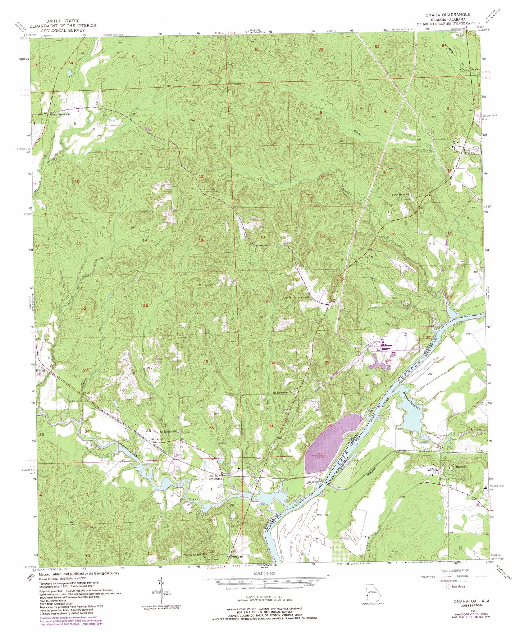
USGS Topo Quad 32085b1 - 1:24,000 scale
| Topo Map Name: | Omaha |
| USGS Topo Quad ID: | 32085b1 |
| Print Size: | ca. 21 1/4" wide x 27" high |
| Southeast Coordinates: | 32.125° N latitude / 85° W longitude |
| Map Center Coordinates: | 32.1875° N latitude / 85.0625° W longitude |
| U.S. States: | AL, GA |
| Filename: | o32085b1.jpg |
| Download Map JPG Image: | Omaha topo map 1:24,000 scale |
| Map Type: | Topographic |
| Topo Series: | 7.5´ |
| Map Scale: | 1:24,000 |
| Source of Map Images: | United States Geological Survey (USGS) |
| Alternate Map Versions: |
Omaha GA 1957, updated 1958 Download PDF Buy paper map Omaha GA 1957, updated 1966 Download PDF Buy paper map Omaha GA 1957, updated 1984 Download PDF Buy paper map Omaha GA 2011 Download PDF Buy paper map Omaha GA 2014 Download PDF Buy paper map |
1:24,000 Topo Quads surrounding Omaha
Marvyn |
Crawford |
Phenix City |
Columbus |
Ochillee |
Hatchechubbee |
Seale |
Fort Mitchell |
Fort Benning |
Cusseta |
Rutherford |
Pittsview |
Omaha |
Union |
Louvale |
Batesville |
Howe |
Twin Springs |
Lumpkin Sw |
Lumpkin |
White Oak |
Eufaula North |
Georgetown |
Sanford |
County Line |
> Back to 32085a1 at 1:100,000 scale
> Back to 32084a1 at 1:250,000 scale
> Back to U.S. Topo Maps home
Omaha topo map: Gazetteer
Omaha: Bridges
Joseph Wilson Smith Bridge elevation 58m 190′Omaha: Crossings
McClouds Ferry (historical) elevation 58m 190′Omaha: Parks
Bluff Creek Access Area elevation 61m 200′Briar Creek Park elevation 62m 203′
Hatchechubbee Creek Park elevation 58m 190′
Omaha: Populated Places
Cottonton elevation 67m 219′Hirsch elevation 70m 229′
Holy Trinity elevation 95m 311′
Jernigan elevation 92m 301′
Loflin elevation 97m 318′
McLendon elevation 69m 226′
Omaha elevation 92m 301′
Sawokli (historical) elevation 61m 200′
Spring Grove (historical) elevation 64m 209′
Omaha: Post Offices
Cottonton Post Office elevation 68m 223′Holy Trinity Post Office elevation 97m 318′
Omaha: Reservoirs
Newsoms Pond elevation 76m 249′Omaha: Streams
Bluff Creek elevation 58m 190′Briar Creek elevation 58m 190′
Briar Creek elevation 59m 193′
Buck Creek elevation 58m 190′
Hannahatchee Creek elevation 58m 190′
Hatchechubbee Creek elevation 58m 190′
Mill Creek elevation 58m 190′
Rocky Creek elevation 58m 190′
Sand Branch elevation 58m 190′
Omaha digital topo map on disk
Buy this Omaha topo map showing relief, roads, GPS coordinates and other geographical features, as a high-resolution digital map file on DVD:
Gulf Coast (LA, MS, AL, FL) & Southwestern Georgia
Buy digital topo maps: Gulf Coast (LA, MS, AL, FL) & Southwestern Georgia
 & Southwestern Georgia map DVD")